
Bullaburra, New South Wales facts for kids
Quick facts for kids BullaburraNew South Wales |
|||||||||||||||
|---|---|---|---|---|---|---|---|---|---|---|---|---|---|---|---|

Rhondda Valley
|
|||||||||||||||
| Population | 1,300 (2021 census) | ||||||||||||||
| Postcode(s) | 2784 | ||||||||||||||
| Elevation | 769 m (2,523 ft) | ||||||||||||||
| Location |
|
||||||||||||||
| LGA(s) | City of Blue Mountains | ||||||||||||||
| State electorate(s) | Blue Mountains | ||||||||||||||
| Federal Division(s) | Macquarie | ||||||||||||||
|
|||||||||||||||
Bullaburra is a small town in New South Wales, Australia. It's part of the City of Blue Mountains. This town is one of many that sit along the Main Western railway line and Great Western Highway. These routes cross the beautiful Blue Mountains, west of Sydney. The name Bullaburra comes from an Aboriginal word. It means clear day.
Contents
What is Bullaburra Like?
Bullaburra is located between two other towns: Lawson to its east and Wentworth Falls to its west. In 2001, the population of Bullaburra and Lawson together was 3,637 people.
The town has its own railway station. It is served by NSW TrainLink's Blue Mountains Line. There's also a fun playground for kids.
You can find two parks nearby: Red Gum Park and Sir Henry Parkes Park. Red Gum Park is on the south side of town. Inside Red Gum Park, you'll discover Minnatonka Falls, a lovely waterfall. Another interesting spot is Rhondda Valley, a large property just west of Bullaburra.
The famous Blue Mountains National Park is close by. This park is a World Heritage Site. This means it's a very special place recognized globally for its natural beauty. The park is located both north and south of Bullaburra.
Exploring Nature: Bushwalks
If you love walking in nature, Bullaburra has some great options.
Bruce's Walk: A Historic Trail
A walking track was built in this area way back in 1931. It was first made for workers to maintain an electricity line. This line brought power from Lithgow to Lawson. The people in charge then decided to turn this maintenance path into a walking trail. It officially opened on November 21, 1931.
The surveyor who planned the track was named A. Bruce. Because of him, the track eventually became known as Bruce's Walk. This trail passed through the north side of Bullaburra on its way to Lawson. A small book was even published to tell people about the walk. It showed off different types of scenery, like peaceful valleys and high ridges.
However, after World War II, people forgot about the track. Parts of it were even blocked off when a dam was built in 1942 for local water. Much later, a local walker named Dick Rushton found an old copy of that 1931 book. He decided to clear and mark the track again. In 1980, he led a group of walkers along the section between Bullaburra and Wentworth Falls. In 1983, he even wrote a guide for the track.
By 1986, two other walkers, Jim Smith and Wilf Hilder, learned about Bruce's Walk. They organized a group of volunteers to help clear the path between Bullaburra and Wentworth Falls. As they worked, they found many old items and features. These included signs, shelter caves, seats, and picnic tables. This part of the track officially opened on May 24, 1986. Many people attended, including Dick Rushton, who was 80 years old by then. Other parts of the track, from Wentworth Falls to Medlow Bath, were also cleared by volunteers later in 1986. Today, the track can still be a bit hard to follow, and it's not always shown on maps.
Red Gum Park Walks
On the south side of Bullaburra, Red Gum Park offers more walking opportunities. You can start these walks from De Quency Road and Cottle Road. The main highlight of this park is Minnatonka Falls. It's not far from the homes on Boronia Road. The walking paths go past the falls and follow part of the creek that flows from them.
Images for kids
-
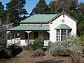
Cottage in Bullaburra
-
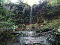
Minnatonka Falls after little rain
-

General store in Bullaburra, circa 1930s
-
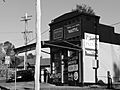
The same shop in 2008


Getting Around Bullaburra
Blue Mountains Transit runs one bus route through Bullaburra:
- 690K: This bus travels from Springwood to Katoomba. It passes through towns like Faulconbridge, Hazelbrook, Wentworth Falls, and Leura.
