Bundure, New South Wales facts for kids
Quick facts for kids BundureNew South Wales |
|
|---|---|

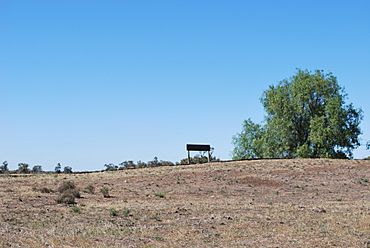
Disused rail siding at Bundure
|
|
| Population | 274 (2006 census) |
| Postcode(s) | 2663 |
| Elevation | 109 m (358 ft) |
| Location |
|
| LGA(s) | Murrumbidgee Council |
| County | Urana |
| State electorate(s) | Albury |
| Federal Division(s) | Farrer |
Bundure is a small rural community located in the central southern part of the Riverina region in New South Wales, Australia. It's a quiet place, surrounded by the beautiful Australian countryside.
In 2006, about 274 people lived in Bundure. This makes it a close-knit community where many people know each other.
Contents
Discovering Bundure
Where is Bundure Located?
Bundure is found in the Murrumbidgee Council area. If you were driving, it's about 25 kilometres southwest of a place called Widgiewa. It's also around 33 kilometres northeast of the town of Jerilderie.
The community is quite a distance from larger cities. For example, it's about 623 kilometres southwest of Sydney, the capital city of New South Wales. It's also 141 kilometres south of Griffith, another important town in the Riverina.
What Does the Name "Bundure" Mean?
The name Bundure has a special meaning. It comes from the local Aboriginal language. The original word was Bundoora.
Bundoora means "place of meeting of many Kangaroos." This name tells us a lot about the area's history and its native wildlife. It suggests that kangaroos were, and perhaps still are, a common sight in this region.
A Glimpse into Bundure's History
Like many small communities, Bundure has a bit of history tied to its services. One interesting fact is about its Post Office.
The Bundure Post Office first opened its doors on 1 September 1926. However, it didn't stay open continuously. It closed for a few years between 1930 and 1934. After reopening, it continued to serve the community until it finally closed down in 1973. This shows how services in rural areas can change over time.
 | Mary Eliza Mahoney |
 | Susie King Taylor |
 | Ida Gray |
 | Eliza Ann Grier |


