Bungay River facts for kids
The Bungay River is a short river located in southeastern Massachusetts. It is a "tributary," meaning it flows into a larger river called the Ten Mile River.
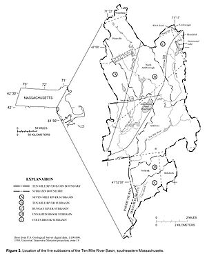
The Bungay River begins in Witch Pond in Foxborough, Massachusetts. This starting point is about 157 feet (48 meters) above sea level. From there, it flows south through a lake called Greenwood Lake. It continues its journey through the towns of North Attleboro and Attleboro.
Finally, the Bungay River joins the Ten Mile River in Attleboro. The Ten Mile River then flows into Narragansett Bay. The Bungay River is about 7.2 miles (11.6 kilometers) long.
Contents
What Makes the Bungay River Special?
The Bungay River is known for its beautiful natural areas. It flows through one of the best red maple swamps in Massachusetts. A red maple swamp is a type of wetland where red maple trees grow.
The river is also a great spot for canoeing. Many people enjoy paddling along its calm waters. The river and the wetlands around it are being studied. Experts are looking at ways to protect these areas as homes for wildlife.
Rivers That Feed the Bungay
Rivers often have smaller streams that flow into them. These smaller streams are called "tributaries." The Bungay River has a few named tributaries.
Named Tributaries
- The West Branch
- Black Brook
There are also many other small, unnamed streams that help feed the Bungay River.
About Bungay Lake
Bungay Lake is a private lake that the Bungay River flows through. On some maps, it is called Greenwood Lake.
Lake Details
- Bungay Lake covers about 110 acres (0.45 square kilometers).
- It is located in North Attleboro and Mansfield.
- The lake was first created in the 1700s. This happened when a dam was built on the Bungay River. The dam was near where the West Branch tributary joins the river.
- Bungay Lake is classified as "Class A water." This means its water is very clean and of high quality.
 | Delilah Pierce |
 | Gordon Parks |
 | Augusta Savage |
 | Charles Ethan Porter |


