
Attleboro, Massachusetts facts for kids
Quick facts for kids
Attleboro, Massachusetts
|
|||
|---|---|---|---|

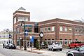
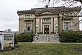
Attleboro's city hall
|
|||
|
|||
| Nicknames:
The Jewelry City, A-Town
|
|||
| Motto(s):
Go Big Blue
|
|||

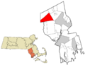
Location in Bristol County in Massachusetts
|
|||

Attleboro, Massachusetts
Location in Massachusetts

Attleboro, Massachusetts
Location in the United States

Attleboro, Massachusetts
Location in North America
|
|||
| Country | United States | ||
| State | Massachusetts | ||
| County | Bristol | ||
| Settled | 1634 | ||
| Incorporated | 1694 (town) | ||
| Reincorporated | 1914, (city) | ||
| Named for | Attleborough, England | ||
| Government | |||
| • Type | Mayor-council city | ||
| Area | |||
| • Total | 27.77 sq mi (71.93 km2) | ||
| • Land | 26.78 sq mi (69.36 km2) | ||
| • Water | 0.99 sq mi (2.57 km2) | ||
| Elevation | 138 ft (42 m) | ||
| Population
(2020)
|
|||
| • Total | 46,461 | ||
| • Density | 1,734.98/sq mi (669.87/km2) | ||
| Time zone | UTC-5:00 (EST) | ||
| • Summer (DST) | UTC-4:00 (EDT) | ||
| ZIP code |
02703
|
||
| Area code(s) | 508 / 774 | ||
| FIPS code | 25-02690 | ||
| GNIS feature ID | 0612033 | ||


Attleboro is a city in Bristol County, Massachusetts, United States. It was once known as "The Jewelry Capital of the World." This is because many jewelry companies were located here. In 2020, about 46,461 people lived in Attleboro.
Contents
History of Attleboro
English settlers first came to the area that is now Attleboro in 1634. They bought the land from a Native American leader named Wamsutta. This land also included what are now Cumberland, Rhode Island (until 1747) and North Attleborough, Massachusetts (until 1887).
In 1697, to keep the town safe, leaders decided to watch newcomers. They even banned some people from entering the town. In 1914, Attleboro became a city. Its name was shortened from "Attleborough" to "Attleboro." The city is named after a market town in Norfolk, England.
Early Times and Famous Visitors
During the colonial era, a local resident named Nathaniel Woodcock was sadly killed. His father's house is now a historical site. It is said that George Washington once visited Attleboro. He supposedly stayed near the Woodcock Garrison House at the Hatch Tavern. There, he traded a shoe buckle with Israel Hatch, a soldier from the American Revolutionary War.
Attleboro's Jewelry Industry
Attleboro became famous for making jewelry around 1913. A big company called the L.G. Balfour Company was a major reason for this. Even though Balfour has moved, Attleboro is still known for its jewelry. Many jewelry companies still operate here today. Some of these include Guyot Brothers Company, General Findings, and Leach & Garner.
Environmental Concerns
Over the years, there have been some environmental concerns in Attleboro. State officials have looked into health patterns in the city. They also investigated the former Shpack Landfill, which is on the border of Norton and Attleboro. This landfill contained different materials, and investigations focused on making sure the area was safe.
Geography of Attleboro
.jpg)
Attleboro covers about 71.93 square kilometers (27.77 square miles). Most of this area is land, and a small part is water. The city's shape is a bit like a triangle pointing west.
Neighboring Towns and Areas
Attleboro shares borders with several towns. To the north is North Attleborough, Massachusetts. To the east are Mansfield, Massachusetts and Norton, Massachusetts. To the south are Rehoboth, Seekonk, Massachusetts, and Pawtucket, Rhode Island. To the west is Cumberland, Rhode Island. Attleboro also has a short border with Central Falls, Rhode Island, along the Blackstone River.
The city includes many smaller areas. Some of these are City Center, Briggs Corner, West Attleboro, and South Attleboro, Massachusetts.
Waterways and High Points
Important waterways in Attleboro include the Ten Mile River. This river is fed by the Bungay River. There are also the Manchester Pond Reservoir and several small ponds.
The highest point in Attleboro is Oak Hill. It is about 76 meters (249 feet) tall and is in the southern part of the city.
Population and People

| Historical population | ||
|---|---|---|
| Year | Pop. | ±% |
| 1790 | 2,166 | — |
| 1800 | 2,480 | +14.5% |
| 1810 | 2,716 | +9.5% |
| 1820 | 3,055 | +12.5% |
| 1830 | 3,215 | +5.2% |
| 1840 | 3,585 | +11.5% |
| 1850 | 4,200 | +17.2% |
| 1860 | 6,066 | +44.4% |
| 1870 | 6,769 | +11.6% |
| 1880 | 11,111 | +64.1% |
| 1890 | 7,577 | −31.8% |
| 1900 | 11,335 | +49.6% |
| 1910 | 16,215 | +43.1% |
| 1920 | 19,731 | +21.7% |
| 1930 | 21,769 | +10.3% |
| 1940 | 22,071 | +1.4% |
| 1950 | 23,809 | +7.9% |
| 1960 | 27,118 | +13.9% |
| 1970 | 32,907 | +21.3% |
| 1980 | 34,196 | +3.9% |
| 1990 | 38,383 | +12.2% |
| 2000 | 42,068 | +9.6% |
| 2010 | 43,593 | +3.6% |
| 2020 | 46,461 | +6.6% |
| 2022 | 46,601 | +0.3% |
Source: United States Census records and Population Estimates Program data. Source: |
||
Attleboro is part of the Providence metropolitan area. It is also close to Boston.
In 2010, there were 43,593 people living in Attleboro. The city had about 16,884 households. Most people were White (87.1%). There were also African American (3.0%), Asian (4.5%), and Native American (0.2%) residents. About 6.3% of the population was Hispanic or Latino.
The average age in Attleboro was about 39.5 years old. About 22.7% of the people were under 18.
Economy and Growth
Attleboro has been working to improve its downtown area. In 2011, the city received $5.4 million to help with these efforts. The money was used to turn old industrial areas into new spaces. These new spaces include shops, parks, and homes. The funds also helped improve public transportation like the MBTA Commuter Rail and GATRA bus services. Road improvements were also part of the plan.
Arts and Culture

Attleboro has several interesting places to visit.
Museums and Attractions
The city has four museums:
- The Attleboro Arts Museum
- The Attleboro Area Industrial Museum
- The Women at Work Museum
- The Museum at the Mill
Other fun places in Attleboro include:
- Capron Park Zoo: A great place to see animals.
- L.G. Balfour Riverwalk: A park by the river, where the old Balfour jewelry plant used to be.
- La Salette Shrine: Famous for its amazing Christmas lights display. It also has one of the largest collections of Nativity scenes in North America.
- Oak Knoll Wildlife Sanctuary: A 75-acre nature area with a visitor center. It is owned by the Massachusetts Audubon Society.
- Skyroc Brewery
- Attleboro Farmers Market
Since 2017, Attleboro has hosted the annual Jewelry City Steampunk Festival.
The National Shrine of Our Lady of La Salette

In 1942, the Missionaries of La Salette bought 135 acres of land and a castle in Attleboro. They used it as a seminary, a place for religious training. The shrine opened to the public in 1953 with a Christmas manger display.
The annual Christmas Festival of Lights is now very popular. It has 300,000 lights and attracts about 250,000 visitors each year. A fire destroyed the castle in 1999. A new welcome center opened in 2007 with a 600-seat concert hall. Besides the Christmas Festival, the shrine offers programs, concerts, and events all year. The grounds also have Our Lady's Chapel of Lights and an outdoor chapel.
Parks and Recreation
Attleboro has more than 20 conservation areas. These areas cover over 600 acres of woods where you can walk and enjoy nature. Some popular spots include the Antony Lawrence Preserve, Coleman Reservation, and Attleboro Springs.
Education in Attleboro
.jpg)
The Attleboro School District has five elementary schools, three middle schools, and two high schools. The high schools are Attleboro High School and Attleboro Community Academy. Attleboro High School has its own vocational division. Its football team, the "Blue Bombardiers," has a big rivalry with North Attleborough High School. They play a special game on Thanksgiving Day.
Attleboro Community Academy is a night school. It helps students aged 16–25 earn their high school diplomas. Bishop Feehan High School is a private Catholic high school that opened in 1961.
Attleboro also has a branch of Bristol Community College. This college is located at an old Texas Instruments site. Bridgewater State University also opened a satellite site in Attleboro in 2009.
Attleboro High School Buildings
The former Attleboro High School building was built in the 1960s. It had many additions over the years. The city decided to build a new high school instead of renovating the old one. The sale of the first Attleboro High School, built in 1912, helped fund the new building. The new Attleboro High School opened its doors in 2022.
Transportation
Attleboro is located near several major roads. These include Interstate 95 and I-295. Other important routes are US Route 1 and Routes 1A, 118, 123, and 152. Routes 118, 123, and 152 all meet in downtown Attleboro.
The city has two MBTA commuter rail stations. One is in the downtown area. The other is in the South Attleboro district, close to Rhode Island. Attleboro also has bus service provided by the Greater Attleboro Taunton Regional Transit Authority (GATRA). This service connects Attleboro with Taunton, Massachusetts and nearby areas.
Notable People
Many interesting people have connections to Attleboro:
- Cathy Berberian (1925–1983): A composer and singer.
- Roger Bowen (1932–1996): A comedic actor, known for the film MASH.
- Geoff Cameron (born 1985): A professional soccer player.
- Horace Capron (1804–1885): An officer during the American Civil War who later helped improve farming in Japan.
- Ray Conniff (1916–2002): A famous easy listening music artist.
- Thomas Hobson: An actor and singer, known for The Fresh Beat Band.
- William Manchester (1922–2004): A well-known historian and author.
- Robert Rounseville (1914–1974): An opera singer who appeared in films and musicals.
- Ken Ryan (born 1968): A former baseball pitcher for the Boston Red Sox.
- Abby Trott: A voice actress known for Demon Slayer: Kimetsu no Yaiba.
Images for kids
-
Attleboro's city hall
-
Seal of Attleboro
-
Flag of Attleboro
-
Location in Bristol County in Massachusetts
-
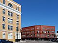
Downtown Attleboro
-

Capron Park
-
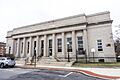
Attleboro Post Office
-
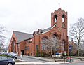
Second Congregational Church
-
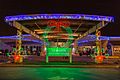
La Salette Shrine is a local tourist destination for its holiday light displays.
-
Attleboro Public Library
See also
 In Spanish: Attleboro (Massachusetts) para niños
