Bureau Junction, Illinois facts for kids
Quick facts for kids
Bureau Junction, Illinois
Bureau
|
|
|---|---|

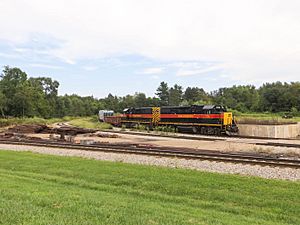
An Iowa Interstate train at the railroad junction.
|
|

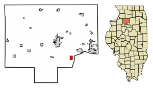
Location of Bureau Junction in Bureau County, Illinois.
|
|

Location of Illinois in the United States
|
|
| Country | United States |
| State | Illinois |
| County | Bureau |
| Township | Leepertown |
| Area | |
| • Total | 1.51 sq mi (3.9 km2) |
| • Land | 1.45 sq mi (3.8 km2) |
| • Water | 0.07 sq mi (0.2 km2) |
| Population
(2020)
|
|
| • Total | 281 |
| • Density | 186.1/sq mi (71.9/km2) |
| Time zone | UTC-6 (CST) |
| • Summer (DST) | UTC-5 (CDT) |
| Area code(s) | 815 |
| FIPS code | 17-09681 |
| Wikimedia Commons | Bureau Junction, Illinois |
Bureau Junction, often called Bureau, is a small village in Bureau County, Illinois, United States. In 2020, about 281 people lived there. Even though its official name is "Bureau Junction," many people, including phone companies and the Post Office, just call it "Bureau." It's part of the Ottawa Micropolitan Statistical Area.
Bureau Junction was once a very important spot for trains. It was where the Rock Island Line railroad had a special branch line that went to Peoria. Today, train tracks west and south of Bureau are used by a company called Iowa Interstate. The tracks going east to Chicago are also used by Iowa Interstate, though they used to be operated by CSX.
History of Bureau Junction
The village gets its name from brothers named Michel or Pierre Bureau. Their real last name might have been Belleau, but local Native Americans found it hard to say the "l" sound. One or both of these brothers ran a trading post near where Big Bureau Creek flows into the Illinois River. They were there from about 1776 to 1780 or 1790. Later, around 1821, a fur trader named Buero, who was part French and part Native American, also worked in this area. He might have been a descendant of the earlier Bureau brothers.
By 1874, Bureau Junction became a busy place for railroads. It was exactly halfway between Chicago and Rock Island on the train line, making it a key stop.
Where is Bureau Junction?
Bureau Junction is located at 41°17′21″N 89°22′4″W / 41.28917°N 89.36778°W.
The village covers a total area of about 1.51 square miles (3.91 square kilometers). Most of this area, about 1.45 square miles (3.76 square kilometers), is land. The rest, about 0.07 square miles (0.18 square kilometers), is water.
People of Bureau Junction
| Historical population | |||
|---|---|---|---|
| Census | Pop. | %± | |
| 1880 | 240 | — | |
| 1890 | 363 | 51.3% | |
| 1900 | 545 | 50.1% | |
| 1910 | 534 | −2.0% | |
| 1920 | 682 | 27.7% | |
| 1930 | 552 | −19.1% | |
| 1940 | 483 | −12.5% | |
| 1950 | 480 | −0.6% | |
| 1960 | 401 | −16.5% | |
| 1970 | 466 | 16.2% | |
| 1980 | 455 | −2.4% | |
| 1990 | 350 | −23.1% | |
| 2000 | 368 | 5.1% | |
| 2010 | 322 | −12.5% | |
| 2020 | 281 | −12.7% | |
| U.S. Decennial Census | |||
In 2020, the village had 281 people living in 82 households. About 56 of these households were families. The population density was about 185.60 people per square mile (71.66 per square kilometer).
Most people in the village, about 86.12%, were White. A small number were Native American or Asian. About 11.74% of the people were from two or more racial backgrounds. Around 9.61% of the population identified as Hispanic or Latino.
About 23.2% of households had children under 18 living with them. Many households (45.12%) were married couples. The average household had about 2.95 people. The average family had about 2.68 people.
The median age in the village was 41.0 years. This means half the people were older than 41 and half were younger.
See also
 In Spanish: Bureau Junction (Illinois) para niños
 | John T. Biggers |
 | Thomas Blackshear |
 | Mark Bradford |
 | Beverly Buchanan |

