Burghfield Brook facts for kids
Quick facts for kids Burghfield Brook |
|
|---|---|

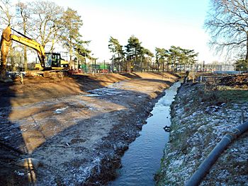
A new path being built for Burghfield Brook near a special site in 2017
|
|
| Country | England |
| Counties | Berkshire |
| Districts / Boroughs | Wokefield Parish, Burghfield Parish |
| Villages | Burghfield Common, Mortimer Common |
| Physical characteristics | |
| Main source | Wokefield Common 95 m (312 ft) 51°23′37″N 1°03′48″W / 51.3935°N 1.0632°W |
| River mouth | Foudry Brook Grazeley Green 40 m (130 ft) 51°25′02″N 0°59′41″W / 51.4171°N 0.9948°W |
| Basin features | |
| Tributaries |
|
Burghfield Brook is a small stream in southern England. It starts in Wokefield Common, which is between the Berkshire villages of Mortimer and Burghfield Common. This brook flows into Foudry Brook near Hartley Court Farm, just south of the M4 motorway.
Journey of Burghfield Brook
Burghfield Brook begins from several natural springs on Wokefield Common. These springs are found near the end of Bundes Lane. The brook then flows east along the northern edge of Wokefield Common. It passes through two small lakes and a valley called Burghfield Slade. Finally, it reaches a reservoir south of Auclum Copse.
The brook forms the boundary between Burghfield to the north and Wokefield to the south. Another small stream also starts nearby and flows east across the common. This stream goes into Pullen's Pond, which is a small fish pond. It briefly disappears underground before joining the main brook in Burghfield Slade and flowing into the reservoir.
A third small stream also starts in Auclum Copse. It flows south to join the reservoir. About 150 acres (60 ha) of Wokefield Common is a special nature reserve. It is looked after by the Berkshire, Buckinghamshire and Oxfordshire Wildlife Trust. They thin the trees to help the heathland grow. Pullen's Pond and Dragonfly Pond are home to many different dragonfly and damselfly species.
Brook's Path and Changes
Water flows out of the reservoir and goes under Man's Hill. After this, there is a sluice, which is a gate that controls water flow. Culverlands Farm is on the north side, and Goddards Green is to the south. The brook then turns towards the north-east.
Near James's Farm in Grazeley Green, another stream called Lockram Brook joins it. Lockram Brook has flowed mostly parallel to Burghfield Brook. The brook continues to mark the border between parishes as it turns north. This continues until it reaches James's Lane and the southern edge of a special site called the Atomic Weapons Establishment, Burghfield.
Long ago, the brook used to curve around Saunderscourt Farm. Then it turned east to reach a bridge called Burnthouse Bridge. In 1938, the Ministry of Defence took over some farmland. They built a factory there called ROF Burghfield. This factory was used to store and handle important equipment.
Later, in 1954, the site became part of the Atomic Weapons Establishment. At some point before 1972, the brook's path was changed. It was moved to flow along the southern and then eastern edge of this important site. It then rejoined its old path at Burnthouse Bridge. From the bridge, it flows east under the railway line. Here, another small stream joins it. This stream starts near the Wokefield Park training centre.
After this junction, the brook flows north. It is joined by The Teg on its left side. The Teg flows from Burghfield, passing north of the special site. Finally, Burghfield Brook joins Foudry Brook just after passing under Kybes Lane. The area near James's Farm often floods, and local councils have discussed ways to manage this.
Water Health
The Environment Agency checks the water quality of rivers in England. They give each river an overall health rating. This rating can be high, good, moderate, poor, or bad. They look at several things to decide this.
- Biological status looks at the types and numbers of living things in the water. This includes tiny invertebrates (like insects), flowering plants, and fish.
- Chemical status checks for harmful chemicals in the water. It compares the amount of chemicals to safe levels. Chemical status is either good or fail.
Here is how Burghfield Brook's water quality was rated in 2019:
| Section | Health for Nature | Chemical Cleanliness | Overall Health | Length | Area |
|---|---|---|---|---|---|
| Burghfield Brook | Moderate | Fail | Moderate | 4.2 miles (6.8 km) | 7.02 square miles (18.2 km2) |
The main reason the water quality is not "good" is because of discharges from industries. This means that some substances from factories or businesses are getting into the brook.
 | Tommie Smith |
 | Simone Manuel |
 | Shani Davis |
 | Simone Biles |
 | Alice Coachman |

