
Foudry Brook facts for kids
Quick facts for kids Foudry Brook |
|
|---|---|

Foudry Brook near Whitley, Berkshire
|
|
| Country | England |
| Counties | Hampshire, Berkshire |
| Towns | Reading, Whitley, Baughurst, Tadley, Stratfield Mortimer |
| Physical characteristics | |
| Main source | Baughurst, Hampshire, United Kingdom 93 m (305 ft) 51°20′00″N 1°09′45″W / 51.333249°N 1.162603°W |
| River mouth | River Kennet Whitley, near Reading, Berkshire, United Kingdom 40 m (130 ft) 51°26′06″N 0°58′39″W / 51.43511°N 0.977381°W |
| Basin features | |
| Tributaries |
|
The Foudry Brook is a small stream in southern England. It starts from many springs near the village of Baughurst in Hampshire. The brook flows east, then north. It eventually joins the River Kennet south of Reading.
The top part of the stream has different names. It is called Bishop's Wood Stream, and then Silchester Brook. The ground underneath the brook is mostly chalk covered by clay. This means the water level can rise quickly after heavy rain. This is because water runs off the clay surface easily. The brook passes by several old buildings and historic sites. These include the ancient Roman town of Calleva Atrebatum or Silchester.
The Foudry Brook's natural water flow gets extra water from two large sewage treatment plants. This extra water can make the brook's water quality poor. Also, changes made to the stream's path make it hard for fish to move freely.
Contents
The Brook's Journey: From Source to River Kennet
Foudry Brook begins at springs between Heath End and Baughurst. Here, it is known as Bishop's Wood Stream. It flows east through Tadley. For a short distance, it flows underground in a pipe, which is called a culvert, beneath houses on Elmhurst.
After coming back to the surface, it goes under the A340 Mulfords Hill road. It then enters a much longer culvert under Tadley Bottom. The brook then appears in open countryside east of Bowmonts Bridge. It crosses the Pamber Forest nature reserve. Here, it becomes the Silchester Brook.
Passing Ancient Roman Sites
The brook turns south. The Silchester Sewage Treatment Works is on its right side. It then flows between two ancient earthworks. These earthworks were part of a Late Iron Age town. This town later became the Roman town called Calleva or Silchester. The earthworks are about 326 meters (1,070 feet) and 274 meters (900 feet) long. There is a gap of about 70 meters (230 feet) where the river flows through.
Honeymill Brook is another stream that joins the Foudry Brook. It starts from a pond near Browninghill Green, south of Baughurst. It also gets water from springs east of the village near Church Brook Farm. These two parts of Honeymill Brook join near Church Road, Tadley. They flow east to Honey Mill Bridge. This bridge carries the A340 Aldermaston Road over the brook. The path of the Port Way, an old Roman road, also crosses here. This is on the western edge of Pamber Forest.
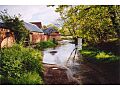
After the forest, Honeymill Brook runs next to the earthworks. It joins Silchester Brook as Silchester Brook turns east again. At Park Copse, high ground stops the brook from going further east. So, it turns north. It passes a moated site. This site has a raised square area, about 25 meters (82 feet) wide. It is surrounded by a moat filled by the stream. There are also some fishponds. Water from the moat flows into Silchester Brook at Clapper's Farm. The Reading to Basingstoke railway follows the valley north, running beside the river.
Crossing into Berkshire
A bit further north, the Devil's Highway crosses the river. This was another Roman road that went from London to Silchester. The Foudry Brook then turns northeast. The West End Brook joins it on its left side. At this point, the Foudry Brook crosses into Berkshire. West End Brook starts near the source of Silchester Brook, but a little further north. It flows east to meet the Foudry Brook.
At the county line, the stream officially becomes the Foudry Brook. At Stratfield Mortimer, it flows close to St Mary's Church. This church was built in 1869. It has beautiful stained glass from the 1400s and 1600s. It also has a Saxon stone coffin lid from 1017. Opposite the church, on the right bank, is a long, narrow fishpond.
The river flows over a small waterfall. This waterfall was once part of a hydraulic ram. This device used the river's power to pump water to Manor House. This spot was also home to a medieval watermill. A mill was mentioned here in the Domesday Book in 1086. There are also records of a mill in 1304 and 1449-50. Tun Bridge carries Station Road to Mortimer railway station. This station was built by Isambard Kingdom Brunel in 1848. It is special because it is one of the few of his stations that looks almost the same as when it was built.
Journey to the River Kennet
After passing the Stratfield Mortimer Sewage Treatment Works, the river turns east near Wokefield Park Training Centre. It goes under the railway line, which continues north. Missels Bridge carries Cross Lane over the river. It then passes another Clappers Farm. This farm has a farmhouse from the 1500s. Reid's Bridge carries the road to Brook Farm.
After this, a ridge of higher ground separates the Foudry Brook valley from the River Loddon valley. So, the Foudry Brook turns north. The small village of Lambwoodhill Common is on the left side. Foudry Bridge is to the south and Gravelly Bridge is to the north. Just before it reaches the M4 motorway, Burghfield Brook joins it on the left side. After the motorway bridge, the stream flows between the Green Park Business Park and the Madejski Stadium. This is a football stadium and training center west of Whitley. Here, the brook provides water for the landscaped lakes.
Finally, it passes under a large roundabout on the A33 road. It continues between Thames Water's Reading sewage treatment works to the west and the Brunel Retail Park to the east. The Foudry Brook then flows into the River Kennet. The Kennet is a canalized river, meaning parts of it have been made deeper and straighter for boats. This is part of the Kennet and Avon Canal. The Foudry Brook joins the Kennet just after Fobney Lock and Bridge 8A. The Kennet then flows through Reading and joins the River Thames.
The Ground Under the River: Geology and Water Flow
The main type of rock under the River Kennet and its smaller streams, like Foudry Brook, is Chalk. In the western part of the Kennet area, the chalk is right at the surface. But in the east, where Foudry Brook is, the chalk is covered by layers of clay and sand.
This makes Foudry Brook act like a "clay catchment river." This means the amount of water flowing in it can change a lot. When it rains heavily, the water can't soak into the clay ground. So, it quickly runs off the surface and into the river. This causes the river's water level to rise very fast.
River Health: Ecology and Water Quality
In 2004, Foudry Brook's water quality was rated 'c' to 'd' by the Environment Agency. This was on a scale where 'a' was the best and 'f' was the worst. Experts thought this was because treated wastewater from sewage treatment plants was flowing into the lower parts of the brook.
Today, a new system is used to check river health in England. Each river gets an "overall ecological status." This can be high, good, moderate, poor, or bad. To figure this out, they look at several things:
- Biological status: This checks the number and types of living things in the water. This includes small creatures without backbones (like insects and worms, called invertebrates), flowering plants (called angiosperms), and fish.
- Chemical status: This checks the levels of different chemicals in the water. They compare these levels to safe amounts. Chemical status is either "good" or "fail."
Here's how the Foudry Brook system's water quality was rated in 2019:
| Section | Ecological Status |
Chemical Status |
Overall Status |
Length | Catchment |
|---|---|---|---|---|---|
| Silchester Brook | Moderate | Fail | Moderate | 6.9 miles (11.1 km) | 8.94 square miles (23.2 km2) |
| West End Brook (tributary of Foudry Brook) | Poor | Fail | Poor | 1.1 miles (1.8 km) | 4.27 square miles (11.1 km2) |
| Burghfield Brook | Moderate | Fail | Moderate | 4.2 miles (6.8 km) | 7.02 square miles (18.2 km2) |
| Foudry Brook (West End Brook to M4) | Poor | Fail | Poor | 7.7 miles (12.4 km) | 9.08 square miles (23.5 km2) |
The water quality of Silchester Brook has gotten better. It went from "poor" in 2015 to "moderate" in 2016. Most of the reasons it's not "good" are linked to sewage flowing into it. West End Brook's quality got worse, dropping from "moderate" to "bad" in 2015. The main reasons for this are changes to the stream's path. These changes stop fish from moving freely. Also, an invasive species called the North American signal crayfish is present. Burghfield Brook is affected by waste from industries. The main issues for the Foudry Brook itself are physical changes to its channel and sewage.
The brook can flood along its path. This has caused the most problems near Whitley. Here, the presence of water voles makes it difficult to build higher banks or expand water-meadows to control flooding.
Protecting the Brook: Pollution Incidents
There have been a few pollution incidents affecting Foudry Brook. In 2002, a company was found responsible for petrol leaking into the ground. This petrol then entered a stream that feeds into Foudry Brook. The leak happened from an underground petrol tank and pipes at a service station in Tadley. Between 1999 and 2001, a large amount of petrol, possibly up to 10,000 liters, seeped into the ground.
In July 2010, a serious leak from a sewage works near Silchester caused a lot of harm. This leak killed hundreds of fish and many other living things along a three-mile stretch of the brook.
Images for kids
-
A ford across Foudry Brook at Clapper's Farm, near Silchester

