West End Brook facts for kids
Quick facts for kids West End Brook |
|
|---|---|

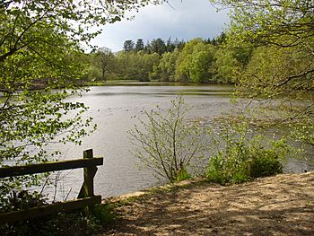
West End Brook at Kiln Pond, Benyon's Inclosure, Hampshire.
|
|
| Country | England |
| Counties | , Hampshire |
| Towns | Tadley, Mortimer West End |
| Physical characteristics | |
| Main source | Tadley Hampshire, United Kingdom 103 m (338 ft) 51°21′36″N 1°08′43″W / 51.359924°N 1.145153°W |
| River mouth | Foudry Brook Hampshire, United Kingdom 59 m (194 ft) 51°21′44″N 1°03′11″W / 51.362296°N 1.053164°W |
West End Brook is a small stream (a narrow river) in southern England. It starts near the village of Tadley in Hampshire. Its name likely comes from Mortimer West End, a village it flows through for part of its journey.
Contents
Where West End Brook Flows
West End Brook begins from springs near Strawberry Farm. This area is north of Tadley and south of the Atomic Weapons Establishment (AWE) Aldermaston. The AWE site used to be an airfield called RAF Aldermaston.
The springs are very close to a special natural area called West's Meadow, Aldermaston. This is a Site of Special Scientific Interest (SSSI). It is a small area of 2.96 acres (1.20 ha) of untouched meadows. These meadows are unusual because their sandy soil stays damp. This is probably due to a layer of clay underground. Over 80 different types of grassland plants grow here, which is a lot for such a small meadow!
The stream flows east through a wooded area. It passes through Upper Moor's Gulley, south of AWE Aldermaston. A smaller stream joins it from the left side. This stream flows south from Decoy Pond, a large pond inside the AWE site.
Roundwood Copse and Decoy Pit
This area, known as Roundwood Copse, is also an SSSI. It is called Decoy Pit, Pools and Woods. This special area covers about 50.08 acres (20.27 ha). It has many different natural habitats. These include grasslands, heathland, woodlands, and small ponds.
This SSSI is famous for having more types of breeding dragonfly and damselfly than anywhere else in Berkshire. It also has rare Alder trees.
Further east, another small stream joins West End Brook from the right side. This stream starts from springs in Roundwood Gulley. The brook then flows under Soke Road. At this point, Soke Road briefly follows an old Roman road. The brook also crosses into Hampshire here.
Kiln Pond and The Frith
The river continues through the woods of Benyon's Inclosure. It then flows into Kiln Pond. A raised path goes over the pond, splitting it into two parts. In the past, both parts were used as fish ponds.
Just south of the pond is The Frith. This is an Iron Age Hill fort. It has simple earth walls that surround the top of a hill. The fort is about 520 feet (160 m) by 390 feet (120 m). We don't have records of any archaeological digs here. However, some parts near its entrance have been damaged by tree planting.
Silchester Roman Town is about 0.6 miles (1 km) to the south-east. The fort at The Frith might have been connected to the Iron Age town that was there before the Roman one.
Journey to Foudry Brook
A stream from two springs in Benyon's Inclosure joins the brook on its left side. This happens as it passes under Church Road. Here, the brook is about 240 feet (73 m) above sea level. Another old Roman road crosses the brook at Lovegrove's Farm.
The brook is then joined by another stream. This stream drains water from Hundred Acre Piece, a large woodland to the north. West End Brook then flows under Turk's Lane. As it turns south, it forms the border between Hampshire and Berkshire counties. After passing under Tanhouse Bridge, which carries Pitfield Lane, it joins Foudry Brook on its left side.
Water Quality of West End Brook
The Environment Agency checks the water quality of rivers in England. They give each river system an overall ecological status. This status can be high, good, moderate, poor, or bad. This rating looks at things like the types and numbers of invertebrates (small creatures without backbones), flowering plants, and fish.
They also check the chemical status. This compares the amount of different chemicals in the water to safe levels. Chemical status is rated either good or fail.
Here's how West End Brook's water quality was in 2019:
| Section | Ecological Status |
Chemical Status |
Overall Status |
Length | Catchment |
|---|---|---|---|---|---|
| West End Brook (tributary of Foudry Brook) | Poor | Fail | Poor | 1.1 miles (1.8 km) | 4.27 square miles (11.1 km2) |
The water quality of West End Brook changed from moderate to bad in 2015. The main reasons for it not being good are:
- The river channel has been changed by humans. This makes it hard for fish to move freely.
- An invasive species called the North American signal crayfish is present. This animal is not native to the area and can harm the local ecosystem.
 | Emma Amos |
 | Edward Mitchell Bannister |
 | Larry D. Alexander |
 | Ernie Barnes |

