Port Way facts for kids
Quick facts for kids Port Way |
|
|---|---|
| The Portway | |
| Lua error in Module:Infobox_road/map at line 15: attempt to index field 'wikibase' (a nil value). | |
 |
|
| Route information | |
| Length | 36.25 mi (58.34 km) |
| Major junctions | |
| From | Calleva Atrebatum |
| Venta Belgarum–Cunetio (Margary route 43) | |
| To | Sorbiodunum |
| Lua error: Country required. | |
The Port Way (also known as the Portway) is an ancient road in southern England. It is often linked to the Roman Empire. The road stretched between Calleva Atrebatum (Silchester) and Sorbiodunum (Salisbury). However, it might have existed even before the Romans arrived in Britain.
When the Romans took over Calleva Atrebatum and Sorbiodunum, this road became part of a longer route. This route connected Londinium (London) and Isca Dumnoniorum (Exeter). Sometimes, "Port Way" refers to this entire long route. But the part from Londinium to Calleva Atrebatum is actually called The Devil's Highway. The section from Sorbiodunum to Vindocladia (Badbury Rings) is known as Ackling Dyke.
Many people who study old things, called antiquarians, have looked at this road. These include Sir Richard Colt Hoare and Ivan Margary. Most of the road's path can still be found today. However, the part east of Hannington in Hampshire has been hard to find for over 100 years. Experts also disagree on its exact path into the Roman town of Calleva Atrebatum.
In the 1950s, Ivan Margary created a system to number Roman roads. The route from Londinium to Isca Dumnoniorum was given the number 4. The Port Way section is known as 4b. Margary measured this part to be about 36.25 miles long.
The Road's Path

The Port Way connected two important places: Calleva Atrebatum (Silchester) and Sorbiodunum (Old Sarum near Salisbury). Both of these towns existed before the Romans came to Britain. This means the road itself might be older than the Roman period. The name "Port Way" comes from the Anglo-Saxon language. Like other old roads with this name, it means a road that connects market towns.
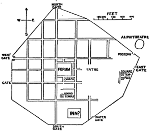
From Calleva Atrebatum, the Port Way continued the south-west direction of The Devil's Highway. This was another Roman road from Londinium. Experts like Ivan Margary and Thomas Codrington thought the road left the town from its western side. Margary believed it connected to the town's Lower West Gate. However, it might have used the main West Gate.
Just a short distance from Calleva Atrebatum, the Port Way crossed an old Iron Age ditch. This was near where a treasure of coins and rings, called the 1985–87 Silchester Hoard, was found. The road continued south-west through Pamber Forest. It then headed towards Cottington Hill, near the village of Hannington.
From Cottington Hill, the road pointed towards Quarley Hill. This hill is near the border between Hampshire and Wiltshire. The road passed through St Mary Bourne and crossed the Bourne Rivulet. Beyond St Mary Bourne, near Finkley and East Anton, the Port Way crossed another Roman road. This was Margary route 43, which went from Venta Belgarum to Cunetio (Mildenhall).
About 1 mile east of this crossroads, there was a mansio. A mansio was like a Roman inn or rest stop. It was the only important settlement along the Port Way, apart from its start and end points. Some people believed this was the Roman settlement of Vindomis. However, later discoveries showed that Vindomis was likely in a different area. The settlement at the East Anton crossroads might have been called Leucomagus.

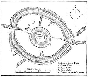
Quarley Hill offered a clear view towards Sorbiodunum. From here, the road turned south-west through the Bourne Valley into Wiltshire. It crossed the river between Winterbourne Gunner and Gomeldon. At Sorbiodunum, the road entered the town from its east side. Here, it met another Roman road, Margary route 45a, from Venta Belgarum.
Beyond Sorbiodunum, the road continued south-west to Vindocladia (Badbury Rings) as Ackling Dyke. It then went west-south-west to Durnovaria. Finally, it went west to Moridunum (near Axminster) and Isca Dumnoniorum (Exeter).
Margary gave the Port Way the number 4b. He said it was 36.25 miles long. Both Calleva Atrebatum and Sorbiodunum are mentioned in an old Roman travel guide called the Antonine Itinerary. However, the distance given between them is 55 Roman miles. This route goes through other towns, not directly along the Port Way.
How the Road Was Built
In 1879, about 0.25 miles of the road near St Mary Bourne was removed. This was done to make it easier for farm vehicles to pass. Workers found the metalled road surface about 4 to 8 inches below the ground. The road itself was about 24 feet wide.
Further west, near the Amesbury railway, a well-preserved part of the road was studied. Margary noted that the main raised part of the road, called the agger, was 27 feet wide here. The road had a base layer of chalk. On top of this, there were 3 to 4 inches of flint. Then, a 12-inch layer of local gravel was placed.
The road was built with a slight curve, called a camber. This made it 18 cm thicker in the middle. This design helped water drain off the road. There were V-shaped ditches on each side of the road. Each ditch was about 1.25 feet deep and 3 feet wide. These ditches were about 32 feet from the south edge and 34.25 feet from the north edge. This made the total width of the road area, including the ditches, about 84.25 feet.
What Remains Today
In 1851, Henry MacLauchlan reported that the road was hard to see from Calleva Atrebatum until the area of Wolverton. Farmers there could sometimes see where the road affected their fields. In 1889, Thomas William Shore said the "great military road" could be traced to the gate at Calleva Atrebatum. However, some Roman roads around the town had disappeared.
In 1903, Thomas Codrington could not clearly find the route between Calleva Atrebatum and Cottington Hill. But in the 1950s, Margary said the agger (the raised road bed) was visible near Tadley and Pamber Green. Traces of the road could also be seen near Stoney Heath. Like other researchers, Margary found it hard to follow the route from this area until Hannington.
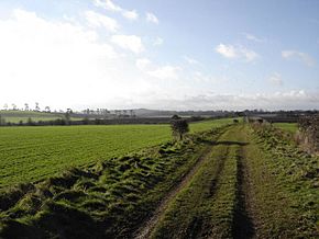
Today, part of the road's route is used by Meadham Lane. A straight section of woodland called Caesar's Belt also follows the road's path. A track continues along the road's route through Bradley Wood. This part is protected as a scheduled monument. After this, the road's path is lost in farmland.
In the St Mary Bourne area, the road's route sometimes forms the boundaries of fields. At Middle Wyke, Finkley Road follows its path into East Anton. As it crosses the Anton Valley, the road's path disappears again. Then, the Andover–Monxton road uses its course. From here to Old Sarum, many lanes, tracks, and droves follow the road's alignment. The West of England railway line also runs parallel to it for some distance.
Archaeologists have found evidence of Roman villas along the Port Way. These include sites at Balchester, Abbotts Ann, Grateley, Hurstbourne Priors, and Allington. Near the Balchester site, there was a Roman fort. Its round shape suggests it was built before the Romans settled there.
Many modern roads along the path of Margary route 4 are still called "Portway." This includes a road west of Gomeldon and a residential road in Riseley. In Andover, "Port Way" has given its name to many places. These include a cul-de-sac, the West and East Portway roads, and two schools. Both schools even use a spoked wheel from a chariot in their school badges!
New housing areas built in the early 21st century near the Port Way/Icknield Way crossroads at East Anton have Roman-themed names. These include The Chariots and Augusta Park. Roads within these areas are named after Roman emperors like Caesar, Claudius, Hadrian, Tiberius, and Vespasian. One road is even named after Augustus's wife, Livia.
 | Kyle Baker |
 | Joseph Yoakum |
 | Laura Wheeler Waring |
 | Henry Ossawa Tanner |

