Burke's Garden, Virginia facts for kids
Quick facts for kids
Burke's Garden
|
|
|---|---|

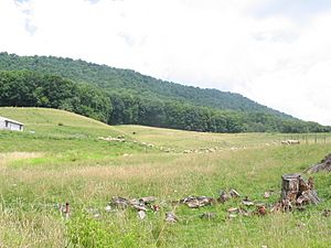
View of Burke's Garden, Virginia, from the center of the basin
|
|

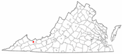
Location of Burke's Garden, Virginia
|
|
| Country | United States |
| State | Virginia |
| County | Tazewell |
| Elevation | 3,074 ft (937 m) |
| Population
(Now)
|
|
| • Total | about 300 |
| • Density | 0.001/sq mi (0.01/km2) |
| Time zone | UTC-5 (Eastern (EST)) |
| • Summer (DST) | UTC-4 (EDT) |
| ZIP code |
24608
|
| Area code(s) | 276 |
| GNIS feature ID | 1498460 |
Burke's Garden is a special valley and a small community in Tazewell County, Virginia. It's known for its beautiful nature and quiet way of life.
This area is surrounded by the Garden Mountain Cluster. These are wild parts of the national forest. They are considered "Mountain Treasures" by a group called the Wilderness Society. This means they are important to protect from things like logging and building new roads.
Contents
Exploring Burke's Garden: Geography and Land
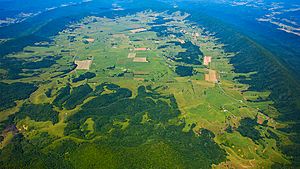
This unique valley looks like a big, oval bowl. It is famous for its very rich and fertile land. Long, long ago, this area was actually covered by an ancient sea!
The valley is about 8.5 miles (13.7 km) long and 4 miles (6.4 km) wide. If you look at it from space or on a map, it might remind you of a giant volcanic crater. But it's not! It's actually a special type of mountain shape called an anticline. This shape caused older, softer rocks to be exposed. These rocks wore away more easily than the harder rocks around them.
Burke's Garden is the second-highest mountain valley in Virginia. It sits about 3,000 feet (914 meters) above sea level. The entire valley is completely surrounded by Garden Mountain. This unusual landscape is similar to Canaan Valley in nearby West Virginia.
Weather in Burke's Garden
Burke's Garden has a climate that is often described as "oceanic." This means it has mild temperatures and rainfall throughout the year.
The hottest temperature ever recorded here was 97°F (36°C) on July 28, 1930. The coldest temperature was a very chilly -27°F (-33°C) on December 30, 1917.
| Climate data for Burke's Garden, Virginia, 1991–2020 normals, extremes 1896–present | |||||||||||||
|---|---|---|---|---|---|---|---|---|---|---|---|---|---|
| Month | Jan | Feb | Mar | Apr | May | Jun | Jul | Aug | Sep | Oct | Nov | Dec | Year |
| Record high °F (°C) | 76 (24) |
73 (23) |
81 (27) |
86 (30) |
92 (33) |
94 (34) |
97 (36) |
96 (36) |
92 (33) |
88 (31) |
77 (25) |
74 (23) |
97 (36) |
| Mean maximum °F (°C) | 59.3 (15.2) |
60.8 (16.0) |
68.7 (20.4) |
76.3 (24.6) |
79.6 (26.4) |
83.0 (28.3) |
84.8 (29.3) |
83.6 (28.7) |
82.1 (27.8) |
76.1 (24.5) |
68.1 (20.1) |
60.7 (15.9) |
85.7 (29.8) |
| Mean daily maximum °F (°C) | 39.3 (4.1) |
42.4 (5.8) |
50.4 (10.2) |
61.2 (16.2) |
68.9 (20.5) |
75.6 (24.2) |
78.8 (26.0) |
77.5 (25.3) |
72.8 (22.7) |
62.6 (17.0) |
51.7 (10.9) |
42.9 (6.1) |
60.3 (15.8) |
| Daily mean °F (°C) | 30.1 (−1.1) |
32.6 (0.3) |
39.7 (4.3) |
49.1 (9.5) |
57.2 (14.0) |
64.7 (18.2) |
68.0 (20.0) |
66.6 (19.2) |
60.9 (16.1) |
50.2 (10.1) |
40.1 (4.5) |
33.4 (0.8) |
49.4 (9.7) |
| Mean daily minimum °F (°C) | 20.9 (−6.2) |
22.9 (−5.1) |
29.0 (−1.7) |
37.1 (2.8) |
45.6 (7.6) |
53.7 (12.1) |
57.3 (14.1) |
55.6 (13.1) |
48.9 (9.4) |
37.8 (3.2) |
28.5 (−1.9) |
23.9 (−4.5) |
38.4 (3.6) |
| Mean minimum °F (°C) | −1.9 (−18.8) |
3.0 (−16.1) |
10.3 (−12.1) |
20.7 (−6.3) |
29.1 (−1.6) |
39.7 (4.3) |
46.0 (7.8) |
44.5 (6.9) |
33.9 (1.1) |
21.0 (−6.1) |
12.4 (−10.9) |
4.3 (−15.4) |
−5.1 (−20.6) |
| Record low °F (°C) | −23 (−31) |
−24 (−31) |
−10 (−23) |
3 (−16) |
19 (−7) |
26 (−3) |
31 (−1) |
30 (−1) |
21 (−6) |
9 (−13) |
−3 (−19) |
−27 (−33) |
−27 (−33) |
| Average precipitation inches (mm) | 3.98 (101) |
3.67 (93) |
4.42 (112) |
4.05 (103) |
4.72 (120) |
4.27 (108) |
4.62 (117) |
4.03 (102) |
3.64 (92) |
3.16 (80) |
2.96 (75) |
4.05 (103) |
47.57 (1,206) |
| Average snowfall inches (cm) | 13.2 (34) |
11.4 (29) |
9.1 (23) |
1.3 (3.3) |
0.0 (0.0) |
0.0 (0.0) |
0.0 (0.0) |
0.0 (0.0) |
0.0 (0.0) |
0.6 (1.5) |
2.2 (5.6) |
9.1 (23) |
46.9 (119.4) |
| Average extreme snow depth inches (cm) | 6.1 (15) |
6.0 (15) |
4.9 (12) |
0.9 (2.3) |
0.0 (0.0) |
0.0 (0.0) |
0.0 (0.0) |
0.0 (0.0) |
0.0 (0.0) |
0.6 (1.5) |
1.4 (3.6) |
4.6 (12) |
9.6 (24) |
| Average precipitation days (≥ 0.01 in) | 14.7 | 12.9 | 13.8 | 12.8 | 15.5 | 15.4 | 16.1 | 14.3 | 10.9 | 10.8 | 10.3 | 13.9 | 161.4 |
| Average snowy days (≥ 0.1 in) | 6.6 | 6.1 | 4.4 | 0.9 | 0.0 | 0.0 | 0.0 | 0.0 | 0.0 | 0.2 | 1.6 | 5.0 | 24.8 |
| Source 1: NOAA | |||||||||||||
| Source 2: National Weather Service | |||||||||||||
History of Burke's Garden: Early Settlers and More
For a very long time, different groups of indigenous peoples lived in this area.
How Burke's Garden Got Its Name
The first survey of Burke's Garden happened in 1748. A team of surveyors was working for a local landowner named James Patton. One of the surveyors, an Irishman named James Burke, was cooking. He reportedly threw some potato peelings on the ground.
A year later, the team came back to the area. They were surprised to find potatoes growing where the peels had been left! As a joke, they started calling the place "Burke's Garden." The name stuck, and that's what it's called today.
In 1749, William Ingles came to Burke's Garden. He helped his uncle, John Ingles, build a house there. Later, in the late 1700s, German immigrants settled in this frontier area.
Community Life and Changes Over Time
Burke's Garden remained quite isolated for a long time. It wasn't near major rivers, which were the main transportation routes back then.
In the late 1800s, the wealthy Vanderbilt family became interested in the area. They wanted to buy land to build a huge estate. However, the local farmers didn't want to sell their land. So, the Vanderbilts built their famous Biltmore Estate in North Carolina instead.
In the 1990s, some Amish families moved to Burke's Garden. They later left because they couldn't buy enough land. They also found it hard to get enough other Amish families to join them.
However, Amish families have since returned to Burke's Garden. They now have a growing community there. You can often see lines of scooters outside the Burke's Garden School and Community Center. This is where the Amish now have their own school. In 2021, the Amish community had about 100 people.
Important Places and Events
The oldest church in the county is in Burke's Garden. It's called the Central Lutheran Church. It was originally called Union Church because it served different Christian groups. When the members learned it had joined the Lutheran group, many left. They then started their own Methodist and Presbyterian churches.
In 1952, the community faced a challenge from the "Varmint of Burke's Garden." This was a large coyote that caused a lot of trouble. It killed many local sheep before it was finally caught.
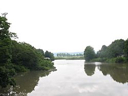
Wolf Creek flows out of the valley in a northeast direction. This creek is a branch of the New River.
The entire valley is recognized as a special historical place. It is listed on the National Register of Historic Places as the Burke's Garden Rural Historic District. The Burke's Garden Central Church and Cemetery is also listed on the National Register.
 | Selma Burke |
 | Pauline Powell Burns |
 | Frederick J. Brown |
 | Robert Blackburn |


