Burns, Tennessee facts for kids
Quick facts for kids
Burns, Tennessee
|
|
|---|---|
| Motto(s):
A hometown community
|
|

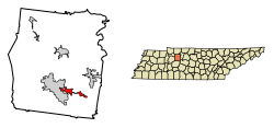
Location of Burns in Dickson County, Tennessee.
|
|
| Country | United States |
| State | Tennessee |
| County | Dickson |
| Government | |
| • Type | Mayor-Council |
| Area | |
| • Total | 3.39 sq mi (8.77 km2) |
| • Land | 3.38 sq mi (8.76 km2) |
| • Water | 0.01 sq mi (0.01 km2) |
| Elevation | 801 ft (244 m) |
| Population
(2020)
|
|
| • Total | 1,573 |
| • Density | 465.25/sq mi (179.62/km2) |
| Time zone | UTC-6 (Central (CST)) |
| • Summer (DST) | UTC-5 (CDT) |
| ZIP code |
37029
|
| Area code(s) | 615 |
| FIPS code | 47-09880 |
| GNIS feature ID | 1305550 |
| Website | http://townofburnstn.net |
Burns is a small town located in Dickson County, Tennessee, in the United States. It's part of a larger area called the Nashville-Davidson–Murfreesboro–Franklin, TN Metropolitan Statistical Area, which means it's connected to the bigger cities nearby. In 2020, about 1,573 people lived in Burns. The town has a motto: A hometown community, showing how friendly and welcoming it aims to be.
Contents
Exploring Burns' Location
Burns is found in the southeastern part of Dickson County. It's near the city of Dickson, which borders Burns on its southwest, west, and northwest sides.
Key Roads in Burns
Two important roads go through Burns:
- Tennessee State Route 47 runs right through the middle of town. If you head west on this road, you'll reach the center of Dickson in about 5 miles. Going northeast for about 7 miles will take you to White Bluff.
- Tennessee State Route 96 passes west and south of the town center. This road leads northwest about 2.5 miles to U.S. Route 70. If you go southeast for about 8 miles, you'll reach Interstate 40 near Fairview.
Land and Water Areas
The United States Census Bureau says that Burns covers a total area of about 9.7 square kilometers (or 3.7 square miles). Most of this area is land, with only a very small part (about 0.02 square kilometers) being water.
Understanding Burns' Population
The population of a town tells us how many people live there. This number changes over time as people move in, move out, are born, or pass away.
How Burns' Population Has Grown
Here's a look at how many people have lived in Burns over the years:
- 1960: 386 people
- 1970: 456 people
- 1980: 777 people
- 1990: 1,127 people
- 2000: 1,366 people
- 2010: 1,468 people
- 2020: 1,573 people
As you can see, the town has grown quite a bit since 1960!
People Living in Burns in 2020
According to the 2020 United States census, there were 1,573 people living in Burns. These people made up 627 households, and 460 of these were families.
See also
 In Spanish: Burns (Tennessee) para niños
 | DeHart Hubbard |
 | Wilma Rudolph |
 | Jesse Owens |
 | Jackie Joyner-Kersee |
 | Major Taylor |

