Dickson, Tennessee facts for kids
Quick facts for kids
Dickson, Tennessee
|
|
|---|---|

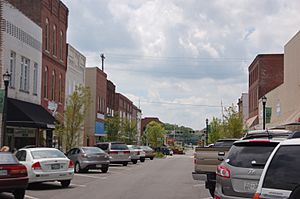
Downtown business district of Dickson
|
|

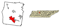
Location of Dickson in Dickson County, Tennessee.
|
|
| Country | United States |
| State | Tennessee |
| County | Dickson |
| Area | |
| • Total | 20.41 sq mi (52.85 km2) |
| • Land | 20.32 sq mi (52.64 km2) |
| • Water | 0.08 sq mi (0.21 km2) |
| Elevation | 804 ft (245 m) |
| Population
(2020)
|
|
| • Total | 16,058 |
| • Density | 790.10/sq mi (305.06/km2) |
| Time zone | UTC-6 (Central (CST)) |
| • Summer (DST) | UTC-5 (CDT) |
| ZIP codes |
37055-37056
|
| Area code(s) | 615 |
| FIPS code | 47-20620 |
| GNIS feature ID | 1303436 |
Dickson is a city in Tennessee, a state in the United States. It's located in Dickson County. This city is also part of the larger Nashville metropolitan area, which means it's close to the big city of Nashville. In 2020, about 16,058 people lived in Dickson.
Contents
History of Dickson, Tennessee
Dickson was named after William Dickson. He was a congressman, a person who helps make laws for the country. Dickson County is also named after him.
How Dickson Started
The city began as a stop on a railroad line. This line connected Nashville to the Tennessee River. During the American Civil War, soldiers built this supply line. The area was then called "Mile 42 post."
What Was Dickson Called Before?
There is some debate about the city's first name. Some people say it was called Sneedsville. This name might have honored a railroad engineer named Sneed. He helped build the tracks for General Ulysses S. Grant.
Other people think the name was Smeedsville. A historian found a court paper from 1867. It referred to the land as "Smeedsville, Dickson County, Tennessee." It's hard to tell if the old handwriting shows an "n" or an "m."
Geography and Location
Dickson is in the southern part of Dickson County. It is next to the town of Burns on its eastern side.
How to Get Around Dickson
U.S. Route 70 runs through the northern part of Dickson. This road is called Henslee Drive there. You can take it east about 40 miles to Nashville. Or you can go west about 62 miles to Huntingdon.
Interstate 40 is a major highway that passes about 5 miles south of Dickson's center. You can get on I-40 from Exit 172, which is Tennessee State Route 46. From this exit, Nashville is about 37 miles east. Jackson is about 92 miles west.
Land and Water in Dickson
The city of Dickson covers about 20.41 square miles. Most of this area is land, about 20.32 square miles. A small part, about 0.08 square miles, is water.
The center of Dickson sits on a special line called the Tennessee Valley Divide. This means water on one side flows in one direction, and water on the other side flows in a different direction.
- Water on the southwest side flows into the East Piney River. This river then goes to the Piney River, then to the Duck River, and finally to the Tennessee River.
- Water on the northeast side flows into Turnbull Creek or Jones Creek. These creeks lead to the Harpeth River and then to the Cumberland River.
Climate in Dickson
| Climate data for Dickson, Tennessee (1991–2020 normals, extremes 1900–present) | |||||||||||||
|---|---|---|---|---|---|---|---|---|---|---|---|---|---|
| Month | Jan | Feb | Mar | Apr | May | Jun | Jul | Aug | Sep | Oct | Nov | Dec | Year |
| Record high °F (°C) | 80 (27) |
82 (28) |
93 (34) |
95 (35) |
98 (37) |
109 (43) |
110 (43) |
110 (43) |
108 (42) |
95 (35) |
88 (31) |
78 (26) |
110 (43) |
| Mean daily maximum °F (°C) | 47.5 (8.6) |
52.3 (11.3) |
61.1 (16.2) |
70.9 (21.6) |
77.4 (25.2) |
84.1 (28.9) |
86.9 (30.5) |
86.9 (30.5) |
81.3 (27.4) |
71.0 (21.7) |
59.5 (15.3) |
50.4 (10.2) |
69.1 (20.6) |
| Daily mean °F (°C) | 37.5 (3.1) |
41.4 (5.2) |
49.4 (9.7) |
58.6 (14.8) |
66.1 (18.9) |
73.5 (23.1) |
76.9 (24.9) |
76.1 (24.5) |
69.9 (21.1) |
59.0 (15.0) |
48.0 (8.9) |
40.5 (4.7) |
58.1 (14.5) |
| Mean daily minimum °F (°C) | 27.5 (−2.5) |
30.4 (−0.9) |
37.7 (3.2) |
46.2 (7.9) |
54.9 (12.7) |
62.9 (17.2) |
66.8 (19.3) |
65.4 (18.6) |
58.5 (14.7) |
46.9 (8.3) |
36.5 (2.5) |
30.6 (−0.8) |
47.0 (8.3) |
| Record low °F (°C) | −23 (−31) |
−14 (−26) |
−1 (−18) |
16 (−9) |
29 (−2) |
38 (3) |
48 (9) |
42 (6) |
32 (0) |
20 (−7) |
−3 (−19) |
−13 (−25) |
−23 (−31) |
| Average precipitation inches (mm) | 4.33 (110) |
4.90 (124) |
5.44 (138) |
4.93 (125) |
5.79 (147) |
4.02 (102) |
4.62 (117) |
3.45 (88) |
3.45 (88) |
4.04 (103) |
3.97 (101) |
5.13 (130) |
54.07 (1,373) |
| Average snowfall inches (cm) | 0.8 (2.0) |
0.6 (1.5) |
0.5 (1.3) |
0.0 (0.0) |
0.0 (0.0) |
0.0 (0.0) |
0.0 (0.0) |
0.0 (0.0) |
0.0 (0.0) |
0.0 (0.0) |
0.0 (0.0) |
0.6 (1.5) |
2.5 (6.4) |
| Average precipitation days (≥ 0.01 in) | 10.3 | 9.9 | 10.4 | 10.2 | 10.2 | 9.6 | 9.3 | 8.0 | 6.7 | 7.9 | 8.9 | 10.5 | 111.9 |
| Average snowy days (≥ 0.1 in) | 0.4 | 0.4 | 0.3 | 0.0 | 0.0 | 0.0 | 0.0 | 0.0 | 0.0 | 0.0 | 0.0 | 0.4 | 1.5 |
| Source: NOAA | |||||||||||||
People of Dickson
| Historical population | |||
|---|---|---|---|
| Census | Pop. | %± | |
| 1890 | 938 | — | |
| 1900 | 1,363 | 45.3% | |
| 1910 | 1,850 | 35.7% | |
| 1920 | 2,263 | 22.3% | |
| 1930 | 2,902 | 28.2% | |
| 1940 | 3,504 | 20.7% | |
| 1950 | 3,348 | −4.5% | |
| 1960 | 5,028 | 50.2% | |
| 1970 | 5,665 | 12.7% | |
| 1980 | 7,040 | 24.3% | |
| 1990 | 8,791 | 24.9% | |
| 2000 | 12,244 | 39.3% | |
| 2010 | 14,538 | 18.7% | |
| 2020 | 16,058 | 10.5% | |
| Sources: | |||
The population of Dickson has grown a lot over the years. In 1890, fewer than 1,000 people lived there. By 2020, the population was over 16,000!
Who Lives in Dickson? (2020 Census)
| Race | Number | Percentage |
|---|---|---|
| White (non-Hispanic) | 12,464 | 77.62% |
| Black or African American (non-Hispanic) | 1,224 | 7.62% |
| Native American | 57 | 0.35% |
| Asian | 170 | 1.06% |
| Other/Mixed | 866 | 5.39% |
| Hispanic or Latino | 1,277 | 7.95% |
In 2020, there were 16,058 people living in Dickson. These people lived in 5,842 households. About 3,690 of these households were families.
Media and Local News
Dickson has its own local TV and radio stations. These help keep the community informed and entertained.
Television Station
- WDHC-LD Channel 6 (This station is part of The Family Channel).
Radio Stations
AM Radio
- WDKN 1260 AM: This station plays Country, Gospel, and Talk shows.
FM Radio
- WLTD-LP 103.9 FM: This station broadcasts 3ABN Radio, which plays religious programs.
- WNRZ 91.5 FM: This station is part of the Bott Radio Network.
Famous People from Dickson
Many interesting people have come from Dickson, Tennessee. Here are a few:
- Frank G. Clement: He was a Governor of Tennessee. A governor is the leader of a state.
- Francis Craig: A talented songwriter and bandleader.
- Trevor Daniel: An American Football punter. He plays for the Tennessee Titans in the National Football League.
- Walter S. Davis: An important educator.
- John Mitchell: A professional baseball player.
- Craig Morgan: A well-known country music singer.
- Anson Mount: An actor who has appeared in movies and TV shows.
- Sunita Mani: An Indian-American actress.
- Anthony Wayne Van Leer: An entrepreneur, which means he started and ran businesses.
Images for kids
-
The Hotel Halbrook Railroad & Local History Museum was added to the National Register of Historic Places in 1990.
See also
 In Spanish: Dickson (Tennessee) para niños
 | Shirley Ann Jackson |
 | Garett Morgan |
 | J. Ernest Wilkins Jr. |
 | Elijah McCoy |


