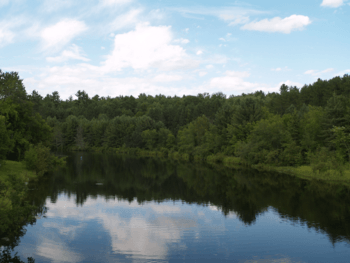
Burnt River (Ontario) facts for kids
Quick facts for kids Burnt River |
|
|---|---|

The Burnt River within Kinmount
|
|
|
Location of the mouth of the Burnt River in southern Ontario
|
|
| Country | Canada |
| Province | Ontario |
| Region | Central Ontario |
| Physical characteristics | |
| Main source | Miskwabi Lake Highlands East, Haliburton County 392 m (1,286 ft) 45°02′29″N 78°22′33″W / 45.04139°N 78.37583°W |
| River mouth | Cameron Lake City of Kawartha Lakes 253 m (830 ft) 44°34′52″N 78°45′55″W / 44.58111°N 78.76528°W |
The Burnt River is a river in Ontario, Canada. It starts at Miskwabi Lake in Highlands East, which is in Haliburton County. The river then flows south into the Kawartha Lakes area.
It eventually flows into Cameron Lake, which is part of the famous Trent–Severn Waterway. The small town of Burnt River is located close to where the river ends.
Contents
Why is it Called the Burnt River?
The river got its interesting name after a big forest fire happened in the area a long time ago. This fire made the river's water look a bit unusual. It probably had a different colour because of the ash and burnt materials.
A River with a Past
Long ago, the Burnt River was very important for moving wood. Loggers used the river to float cut trees, called lumber, down to sawmills. These sawmills would then cut the logs into useful pieces of wood.
Later, a train track called the Victoria Railway was built right alongside the river. Today, this old railway path is no longer used by trains. Instead, it has become a fun trail for people to enjoy. You can walk, bike, or even snowmobile on it!
Fish in the Burnt River
The Burnt River is home to several types of fish. The three main kinds you might find here are walleye, muskie, and smallmouth bass.
These fish usually grow a bit smaller than the ones found in the bigger lakes nearby. However, you can still catch them if you follow the local fishing rules. If you enjoy fishing, you can try different ways to catch them. For example, smallmouth bass can often be caught using a special technique called fly fishing.
Rivers Joining the Burnt River
The Burnt River has other smaller rivers that flow into it. These are called tributaries. They add more water to the main river as it flows along.
 | William L. Dawson |
 | W. E. B. Du Bois |
 | Harry Belafonte |


