
Kawartha Lakes facts for kids
Quick facts for kids
Kawartha Lakes
|
||
|---|---|---|
| City of Kawartha Lakes | ||

Kawartha Lakes city hall in Lindsay
|
||
|
||
| Motto(s):
"Jump In"
|
||

Kawartha Lakes' location within Ontario
|
||
| Country | Canada | |
| Province | Ontario | |
| County (historical) | Victoria | |
| Formed by political merger | January 1, 2001 | |
| Seat | Lindsay | |
| Area | ||
| • Land | 3,084.38 km2 (1,190.89 sq mi) | |
| Population
(2021)
|
||
| • Total | 79,247 | |
| • Density | 26.1/km2 (68/sq mi) | |
| Time zone | UTC-5 (EST) | |
| • Summer (DST) | UTC-4 (EDT) | |
| Postal Code |
K0L, K0M, K9V, L0A, L0B, L0K
|
|
| Area code(s) | 705 / 249 | |
| Website | www.kawarthalakes.ca | |
The City of Kawartha Lakes is a special kind of city in Central Ontario, Canada. It's called a "single-tier" municipality. This means it acts like both a city and a county at the same time. Even though it's called a city, it's very large and mostly rural. In fact, it's the second-largest single-tier municipality in Ontario by land area.
In 2021, about 79,247 people lived here. The main towns and villages are Lindsay (which is the biggest), Bobcaygeon, Fenelon Falls, Omemee, and Woodville.
Contents
History of Kawartha Lakes
The land where Kawartha Lakes is located has a long history. It was traditionally home to the Anishinaabeg, Huron-Wendat, and Haudenosaunee peoples. These are some of Canada's Indigenous peoples.
What Does "Kawartha" Mean?
The name Kawartha comes from the Kawartha Lakes region. It was first used in 1895 by Martha Whetung from the Curve Lake First Nation. She said Ka-wa-tha (from Ka-wa-tae-gum-maug) meant "land of reflections" in the Anishinaabe language. Later, people promoting tourism changed it slightly to Kawartha, saying it meant "bright waters and happy lands."
How the City Was Formed
Before 2001, this area was known as Victoria County. On January 1, 2001, the provincial government decided to combine Victoria County and all its smaller towns and villages into one big city. This process is called an amalgamation. It created the City of Kawartha Lakes.
Many local residents were against this change. In 2003, people in Kawartha Lakes voted to separate again, but the governments have not yet acted on that vote.
People of Kawartha Lakes
In the 2021 Census, the population of Kawartha Lakes was 79,247. This was a small increase from 2016. The area has a land size of about 3,033.66 square kilometers.
Ethnic Backgrounds
People in Kawartha Lakes come from many different backgrounds. The most common ethnic origins reported in 2021 included:
Most residents (93.7%) in 2021 were of White/European background. About 2.9% were Indigenous, and 3.4% were from other visible minority groups.
Religions in Kawartha Lakes
In 2021, about 53.8% of people in Kawartha Lakes identified as Christian. This includes different groups like Protestants (such as United Church, Anglican, and Presbyterian) and Catholics. A growing number of people (44.5%) reported having no religious beliefs. Other religions, like Hinduism, made up a smaller part of the population.
Communities in Kawartha Lakes
The City of Kawartha Lakes is made up of many smaller communities. Some of the main ones are:
- Bobcaygeon
- Fenelon Falls
- Kinmount
- Kirkfield
- Lindsay
- Little Britain
- Omemee
- Pontypool
- Woodville
Climate and Weather
The Kawartha Lakes area has a climate with warm summers and cold, snowy winters. This is known as a humid continental climate. The amount of snow each year usually ranges from 150 to 200 centimeters. Areas closer to large lakes often get more snow.
Getting Around Kawartha Lakes
Kawartha Lakes has different ways to travel, whether by air, water, or land.
Air Travel
The Kawartha Lakes Municipal Airport is a certified airport. It's open 24 hours a day and has fuel for planes. It helps people fly to different places in Ontario.
Water Travel
The many rivers, lakes, and streams in Kawartha Lakes connect towns and villages. The best time to travel by water is from May to October. The famous Trent-Severn Waterway passes through the city. This waterway connects Lake Ontario to Georgian Bay.
There are five special locks in Kawartha Lakes that are part of the Trent-Severn National Historic Site:
- Lock 32: Bobcaygeon
- Lock 33: Lindsay
- Lock 34: Fenelon Falls
- Lock 35: Rosedale
- Lock 36: Kirkfield (a lift lock)
Coboconk is a unique place because it's considered Canada's freshwater summit. This means water flows in two different directions from there, and you can reach oceans from this point!
Land Travel
Several main highways run through the city, including:
- Highway 7 (part of the Trans-Canada Highway)
- Highway 35
- Highway 115
There are also multi-use trails, like the Lindsay-Peterborough rail line, which is part of the Trans Canada Trail. The Victoria Rail Trail is another popular path.
Public Transportation
Because Kawartha Lakes is mostly rural, public transportation is limited. The town of Lindsay has its own bus service called Lindsay Transit. It runs Monday to Saturday and on Sundays. There used to be a rural bus route connecting Lindsay to other towns, but it stopped in 2015. Most school children travel by school bus.
Train Routes
Passenger trains no longer run through most of Kawartha Lakes. The last passenger train left the city in 1990. However, some freight trains still operate through areas like Pontypool. There are discussions about bringing back passenger rail service to connect to Toronto.
Taxi Services and Carpooling
Several private taxi services operate in Kawartha Lakes. Some businesses and organizations also help people find carpooling options.
Fun Things to Do and See
Kawartha Lakes has many attractions for visitors and residents.
Arts and Culture
- Academy Theatre
- Lindsay Little Theatre
- The Lindsay Gallery
- Maryboro Lodge: The Fenelon Museum
- Youngtown Rock and Roll Museum
- Olde Gaol Museum
- Highland Cinema and Museum in Kinmount
Outdoor Adventures
- Devil's Elbow Ski Area in Bethany
- Ganaraska Hiking Trail
- Trans Canada Trail (including Doube's Trestle Bridge)
- Victoria Recreation Corridor
Parks and Nature Areas
Kawartha Lakes is home to several protected natural spaces:
- Queen Elizabeth II Wildlands Provincial Park
- Carden Alvar Provincial Park
- Balsam Lake Provincial Park
- Emily Provincial Park
- Pigeon River Headwaters Conservation Area
- Ken Reid Conservation Area
- Gamiing Nature Centre
Local Media
To stay updated on news and events in Kawartha Lakes, you can check out:
- The Standard News (weekly print and online)
- The Lindsay Advocate (online and print news magazine)
- The Kawartha Promoter (online news magazine)
There are also local radio stations like 91.9 Bounce FM (CKLY-FM) from Lindsay and 100.3 LIFE FM from Peterborough. Global Peterborough, established as CHEX-TV also broadcasts from Peterborough.
Nearby Areas
Kawartha Lakes shares borders with several other counties and regions in Ontario:
- Muskoka District Municipality
- Haliburton County
- Northumberland County
- Peterborough County
- Regional Municipality of Durham
- Simcoe County
Images for kids
-
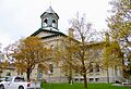
Kawartha Lakes city hall in Lindsay
-
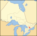
Kawartha Lakes' location within Ontario
See also
 In Spanish: Kawartha Lakes para niños
