Burwash Landing facts for kids
Quick facts for kids
Burwash Landing
|
|
|---|---|
 |
|
| Country | Canada |
| Territory | Yukon |
| Area | |
| • Land | 30.09 km2 (11.62 sq mi) |
| Elevation | 806 m (2,645 ft) |
| Population
(2016)
|
|
| • Total | 72 |
| • Density | 2.4/km2 (6/sq mi) |
| Time zone | UTC−07:00 (MST) |
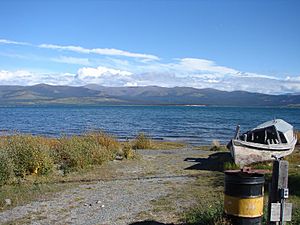
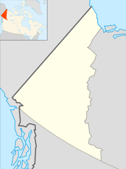
Burwash Landing is a small community in Yukon, Canada. It sits on the southern shore of Kluane Lake, right along the historic Alaska Highway.
This area was first used as a summer camp by the Southern Tutchone Athabascans. Later, in the early 1900s, the Jacquot brothers built a trading post here.
Most people living in Burwash Landing are First Nations people. The community is the main office for the Kluane First Nation. Besides the Alaska Highway, the Burwash Airport also serves the community.
Burwash Landing is home to the Kluane Museum of Natural History. It's also where the Kluane First Nation is located. You can even find the world's largest gold pan here!
In July 1937, two climbers, Robert Bates and Bradford Washburn, arrived in Burwash Landing. They had just climbed the huge 17,146 ft (5,226 m) Lucania peak. After their bush pilot couldn't pick them up, they hiked over 150 mi (240 km) through the wilderness to reach the community.
Contents
Exploring Burwash Landing
Burwash Landing is located on the historic Milepost 1093 of the Alaska Highway. It sits on the northwest shore of Kluane Lake. The airport is about 2,647 ft (807 m) above sea level. Some local places have even been renamed using the Southern Tutchone language.
Weather and Climate
Burwash Landing has a typical subarctic climate. This means it has long, cold winters and short, cool summers. It also borders on a dry-winter subarctic climate.
Burwash Landing holds a special record for the warmest temperature ever in Yukon during January. On January 24, 2014, it reached 16.5 °C (61.7 °F)! The previous record was 10.9 °C (51.6 °F) in Whitehorse.
| Climate data for Burwash Airport | |||||||||||||
|---|---|---|---|---|---|---|---|---|---|---|---|---|---|
| Month | Jan | Feb | Mar | Apr | May | Jun | Jul | Aug | Sep | Oct | Nov | Dec | Year |
| Record high humidex | 7.1 | 11.1 | 10.5 | 18.7 | 28.6 | 31.1 | 34.3 | 31.2 | 24.6 | 21.0 | 10.0 | 11.6 | 34.3 |
| Record high °C (°F) | 16.5 (61.7) |
12.0 (53.6) |
10.5 (50.9) |
20.3 (68.5) |
29.7 (85.5) |
31.7 (89.1) |
28.9 (84.0) |
30.5 (86.9) |
25.5 (77.9) |
21.0 (69.8) |
10.6 (51.1) |
13.5 (56.3) |
31.7 (89.1) |
| Mean daily maximum °C (°F) | −14.3 (6.3) |
−8.8 (16.2) |
−2.3 (27.9) |
5.8 (42.4) |
12.7 (54.9) |
18.0 (64.4) |
19.6 (67.3) |
17.5 (63.5) |
11.3 (52.3) |
2.0 (35.6) |
−8.8 (16.2) |
−11.6 (11.1) |
3.4 (38.1) |
| Daily mean °C (°F) | −20.5 (−4.9) |
−16.4 (2.5) |
−10.8 (12.6) |
−1.2 (29.8) |
5.7 (42.3) |
11.1 (52.0) |
13.1 (55.6) |
10.9 (51.6) |
5.1 (41.2) |
−3.4 (25.9) |
−14.6 (5.7) |
−17.8 (0.0) |
−3.2 (26.2) |
| Mean daily minimum °C (°F) | −26.7 (−16.1) |
−23.8 (−10.8) |
−19.2 (−2.6) |
−8.2 (17.2) |
−1.4 (29.5) |
4.1 (39.4) |
6.4 (43.5) |
4.2 (39.6) |
−1.1 (30.0) |
−8.6 (16.5) |
−20.3 (−4.5) |
−24.0 (−11.2) |
−9.9 (14.2) |
| Record low °C (°F) | −55.0 (−67.0) |
−55.0 (−67.0) |
−48.9 (−56.0) |
−35.1 (−31.2) |
−13.0 (8.6) |
−5.5 (22.1) |
−3.3 (26.1) |
−8.5 (16.7) |
−22.3 (−8.1) |
−35.4 (−31.7) |
−44.7 (−48.5) |
−51.2 (−60.2) |
−55.0 (−67.0) |
| Record low wind chill | −63.9 | −59.9 | −51.9 | −38.0 | −15.6 | −6.6 | −4.6 | −10.5 | −27.6 | −44.0 | −53.0 | −61.0 | −63.9 |
| Average precipitation mm (inches) | 8.4 (0.33) |
7.3 (0.29) |
6.9 (0.27) |
6.8 (0.27) |
24.1 (0.95) |
49.2 (1.94) |
67.9 (2.67) |
41.8 (1.65) |
25.2 (0.99) |
16.1 (0.63) |
10.8 (0.43) |
10.2 (0.40) |
274.7 (10.81) |
| Average rainfall mm (inches) | 0.2 (0.01) |
0.1 (0.00) |
0.0 (0.0) |
0.8 (0.03) |
16.0 (0.63) |
47.9 (1.89) |
67.9 (2.67) |
41.0 (1.61) |
20.0 (0.79) |
2.0 (0.08) |
0.2 (0.01) |
0.0 (0.0) |
196.2 (7.72) |
| Average snowfall cm (inches) | 12.0 (4.7) |
10.4 (4.1) |
9.9 (3.9) |
7.4 (2.9) |
8.8 (3.5) |
1.2 (0.5) |
0.0 (0.0) |
0.8 (0.3) |
5.9 (2.3) |
18.6 (7.3) |
15.8 (6.2) |
15.0 (5.9) |
105.5 (41.5) |
| Average precipitation days (≥ 0.2 mm) | 7.6 | 6.8 | 5.5 | 3.6 | 8.3 | 10.9 | 14.4 | 11.0 | 9.4 | 9.7 | 9.8 | 7.5 | 104.4 |
| Average rainy days (≥ 0.2 mm) | 0.1 | 0.2 | 0.0 | 0.5 | 6.6 | 10.9 | 14.4 | 10.8 | 7.7 | 1.7 | 0.2 | 0.1 | 53.2 |
| Average snowy days (≥ 0.2 cm) | 7.9 | 6.8 | 5.6 | 3.4 | 3.0 | 0.4 | 0.0 | 0.2 | 2.4 | 8.6 | 9.9 | 7.7 | 55.9 |
| Average relative humidity (%) | 74.5 | 68.7 | 57.7 | 47.2 | 42.5 | 45.1 | 50.6 | 51.5 | 54.5 | 66.0 | 77.0 | 76.3 | 59.3 |
| Source: 1981-2010 Environment Canada | |||||||||||||
Population Changes
| Federal census population history of Burwash Landing | ||
|---|---|---|
| Year | Pop. | ±% |
| 1981 | 73 | — |
| 1986 | 64 | −12.3% |
| 1991 | 77 | +20.3% |
| 1996 | 58 | −24.7% |
| 2001 | 68 | +17.2% |
| 2006 | 73 | +7.4% |
| 2011 | 95 | +30.1% |
| 2016 | 72 | −24.2% |
| 2021 | 64 | −11.1% |
| Source: Statistics Canada |
||
According to the 2021 Census, Burwash Landing had a population of 64 people. They lived in 44 homes. This was a small change from its 2016 population of 72 people. The community covers about 30.44 km2 (11.75 sq mi) of land.
Southern Tutchone Culture
Burwash Landing is the traditional home of the Southern Tutchone Athabascans. It was once a summer camp for them. Today, there's a strong effort to bring back and celebrate the Southern Tutchone language and culture.
You can see this when you visit the town. Street and traffic signs in and near Burwash Landing are often in Southern Tutchone. Many important places have been renamed in Southern Tutchone. You can spot these signs along the Alaska Highway.
Unique Burls
Burwash Landing is also known for its special black spruce burls. A burl is a strange growth on a tree. It forms when the tree gets irritated and sends extra sap to heal itself. This sap creates a large, lumpy growth.
Burls can be "green," meaning they are cut from living trees in the spring. Or, they can be "dry burls," taken from trees that have already died. Once the bark is removed, burls can be used in many ways. They can become fenceposts or be shaped into beautiful objects like bowls. If you visit Burlbilly Hill at Milepost 1061.6, you'll see many "burly logs" on display!
 | Toni Morrison |
 | Barack Obama |
 | Martin Luther King Jr. |
 | Ralph Bunche |


