Butterworth (ancient township) facts for kids
| Butterworth | |
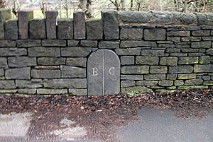
 A boundary stone on the A663 road, marking the ancient border between Butterworth and Crompton |
|
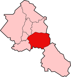
 Butterworth shown within the parish of Rochdale |
|
| Geography | |
| Status | Township (1148–1894) & Civil Parish (1866–1894) |
| 1871 area | 7,766 acres (31.43 km2) |
| 1891 area | 7,766 acres (31.43 km2) |
| History | |
| Created | Middle Ages |
| Abolished | 1894 |
Quick facts for kids Demography |
|
|---|---|
| 1841 population | 5,648 |
| 1891 population | 9,352 |
| Units | Butterworth Freehold, Butterworth Lordship |
Butterworth was a historical area, or township, located in the southeastern part of the parish of Rochdale in England. It covered about 12 square miles (31 square kilometers) of land in the South Pennines hills. This area included several small settlements like Milnrow, Newhey, and Smithy Bridge.
Butterworth stretched to the borders of Crompton in the south. To the east, its boundary reached the high points of Bleakedgate Moor and Clegg Moor, going up to the ridge of Blackstone Edge. This ridge also marked the old county line between Lancashire and Yorkshire.
This area was likely settled a very long time ago, during the Saxon times. The land was divided into two main parts: the Lordship side, where people paid rent or provided services to the local lord, and the Freehold side, which was important for recording births, deaths, and marriages until 1879. In 1830, Butterworth had about 5,554 people living there.
Contents
History of Butterworth
How Butterworth Started
Butterworth's story probably began with the Anglo-Saxon people settling in England many centuries ago. Its name comes from old English words: butere meaning 'butter' and worð meaning 'an enclosed area'. So, it might have been a place known for butter production!
Butterworth was one of four main parts of the ancient parish of Rochdale. We know about its history from records dating back to the mid-1100s. A group called the Order of St John of Jerusalem, also known as the Knights Hospitaller, owned a lot of land here. They often marked their land boundaries with stones or metal crosses.
In 1851, an old house in Butterworth Hall was destroyed by fire. Inside, an iron cross was found, showing that the Knights Hospitaller owned it until King Henry VIII closed down monasteries in the 1530s. Old documents from the 1200s also mention land in Butterworth connected to these knights. Another document from around 1280 talks about rents from Butterworth land being given to the Abbot of Stanlow Abbey.
The name of the township was used by Reginal(d) de Boterworth, who was the local lord. He was given land in the township in 1148. Butterworth Hall itself was built even earlier, before 1166. An old manuscript from the time of King Edward II (early 1300s) spelled the township's name as Buckworth.
How Butterworth Was Governed
The Knights of the Order of St John of Jerusalem held special courts in Butterworth after 1148. These courts helped manage the area. In 1253, they were even allowed to build a gallows, which was a place for executions, on a hill near Milnrow. This spot is still remembered today by the name of a local pub.
Later, these local courts were replaced by a larger court system. Records from the late 1500s and early 1600s show this new system handling disagreements over land and broken agreements. In 1656, a courthouse was built in Milnrow for local judges to hear smaller cases.
The old way of dividing Butterworth into the Lordship side and Freehold side continued into the 1800s. Each side had its own officials, like overseers and constables, who helped manage the area and its people. Laws about helping the poor, which started in the 1600s, were updated in the 1800s.
As factories and industries grew, towns like Milnrow and Newhey became much bigger. This growth changed Butterworth. In 1870, the Milnrow Local Board was created to manage local affairs. Parts of Butterworth, including Hollingworth Lake, were moved to be managed by nearby towns like Littleborough.
In 1894, the Milnrow Local Board became the Milnrow Urban District Council. At this point, Butterworth stopped being its own official township. However, its name lives on in places like Butterworth Hall, the old hall itself, and Butterworth Hall Brook. The area that was once Butterworth is now part of the Metropolitan Borough of Rochdale in Greater Manchester.
Religion in Butterworth
Before the Reformation (a big change in the Christian church in the 1500s), Milnrow had a small church, or chapelry, within the larger parish of Rochdale. In 1400, a special permission was given for a small chapel to be built at Butterworth Hall. This chapel was for Sir John Byron, an ancestor of the famous poet Lord Byron.
In 1496, another chapel was built in Milnrow, next to the River Beal. By 1650, a government report suggested that "Butterworth was fit to be made a parish" on its own. This was because it had a growing population and its chapel was doing well.
By the 1800s, Milnrow had become the most important settlement in Butterworth. In 1866, it officially became a separate parish. A new church, St James, was built there in 1868. Later, in 1876-77, the Church of St Thomas was built in Newhey. This showed that Newhey had become the second most important place in the old township.
 | Charles R. Drew |
 | Benjamin Banneker |
 | Jane C. Wright |
 | Roger Arliner Young |

