
Bütschwil-Ganterschwil facts for kids
Quick facts for kids
Bütschwil-Ganterschwil
|
||
|---|---|---|
_137.JPG)
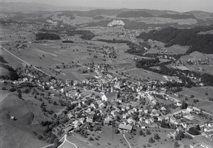
Bütschwil village
|
||
|
||

Bütschwil-Ganterschwil
Location in Switzerland

Bütschwil-Ganterschwil
Location in Canton of St. Gallen
|
||
| Country | Switzerland | |
| Canton | St. Gallen | |
| District | Toggenburg | |
| Area | ||
| • Total | 21.83 km2 (8.43 sq mi) | |
| Elevation | 610 m (2,000 ft) | |
| Highest elevation
(Sedelberg)
|
942 m (3,091 ft) | |
| Lowest elevation
(Thur river)
|
555 m (1,821 ft) | |
| Population
(Dec 2020 )
|
||
| • Total | 5,041 | |
| • Density | 230.92/km2 (598.08/sq mi) | |
| Postal code |
9606 / 9608
|
|
| Surrounded by | Ganterschwil, Krinau, Lichtensteig, Lütisburg, Mosnang, Oberhelfschwil, Wattwil | |

Bütschwil-Ganterschwil is a municipality in Switzerland. It is located in the Toggenburg area, which is part of the St. Gallen canton. This municipality was created on January 1, 2013. It was formed when the two smaller municipalities of Bütschwil and Ganterschwil joined together.
Contents
A Look at History
The area of Bütschwil was first mentioned in old records way back in the year 779. It was known as Bucinesvilare then.
Ganterschwil also appears in records from the same year, 779. Its old name was Cantrichesuilare.
Where is Bütschwil-Ganterschwil?

The combined area of Bütschwil-Ganterschwil is about 21.81 square kilometers (8.42 square miles). A large part of this land is used for farming. Forests cover another good portion. The rest of the land has buildings, roads, or is made up of rivers and lakes.
Bütschwil's Landscape
The former municipality of Bütschwil is located along the Thur river. On one side of the river, you'll find the villages of Bütschwil and Dietfurt. There are also smaller groups of houses called hamlets, like Grämigen and Kengelbach. On the other side of the river are hamlets such as Langensteig.
Ganterschwil's Landscape
The former municipality of Ganterschwil sits on a high flat area. This area is between the Thur and Neckar rivers. It includes the main village of Ganterschwil. You can also find several hamlets here, like Äwil and Tobel. Many scattered farmhouses are also part of the landscape.
Who Lives Here?
As of December 2011, the total population of Bütschwil-Ganterschwil was 4,561 people. The number of people living in the area changes over time.
Getting Around
Bütschwil-Ganterschwil is on the Wil–Ebnat-Kappel railway line. This train line connects the towns of Wattwil and Wil. You can catch a train at two stations within the municipality: Bütschwil and Dietfurt. These stations are part of the St. Gallen S-Bahn network, which is like a local train system.
What to See
The village of Bütschwil is recognized as an important Swiss Heritage Site. This means it has special historical or cultural value.
