
Canton of St. Gallen facts for kids
Quick facts for kids
Kanton St. Gallen
|
||
|---|---|---|
|
||
| Capital | St. Gallen | |
| Subdivisions | 77 municipalities, 8 districts | |
| Area | ||
| • Total | 2,030.75 km2 (784.08 sq mi) | |
| Population
(December 2020)
|
||
| • Total | 514,504 | |
| • Density | 253.3566/km2 (656.1907/sq mi) | |
| ISO 3166 code | CH-SG | |
| Highest point | 3,248 m (10,656 ft): Ringelspitz | |
| Lowest point | 396 m (1,299 ft): Lake Constance | |
| Joined | 1803 | |
| Languages | German | |

The canton of St. Gallen is a region in Switzerland. It is also called the canton of St Gall. Its capital city is St. Gallen.
This canton is in northeastern Switzerland. It covers about 2,026 km2 (782 sq mi). In 2015, nearly half a million people lived there. The canton was created in 1803. It brought together the city of St. Gallen, lands from the Abbey of St. Gall, and other areas that used to belong to the Old Swiss Confederacy.
Contents
History of St. Gallen

The canton of St. Gallen was formed by Napoleon Bonaparte in 1803. This happened during a time of big changes in Switzerland. About half of the canton's land came from areas that the abbey of St. Gallen had owned for many centuries.
The city of St. Gallen became independent from the abbey in 1405. Around the same time, the abbey lost control of a nearby region called Appenzell. However, the abbey gained control of Toggenburg in 1468.
Both the city and the abbey were connected to the Old Swiss Confederacy. But they were not full members like some other regions.
Before 1798, many small areas existed independently. These included the city of St. Gallen, lands of the Abbey, and other towns and lordships.
Changes in the Helvetic Republic
In 1798, the French army invaded Switzerland. The lands that would become St. Gallen were split into two new cantons: Säntis and Linth. These new cantons were part of the Helvetic Republic.
However, these new cantons faced money problems. They introduced unpopular taxes and laws. The Abbey was also closed in 1798, which caused unrest. When a war broke out in 1799, an Austrian army briefly brought the Prince-Abbot back to power. But French forces soon returned and drove him out again.
In 1803, the area officially joined the Swiss Confederation. This was part of a plan called the Act of Mediation. This is when the Canton of St. Gallen was truly formed.
Developing the Canton's Rules
The first constitution for the canton was written in 1803 and updated in 1814. Because people in the canton had different religions, the 1814 constitution handled religious matters, marriage, and education in a special way. It created separate assemblies for Protestants and Catholics.
The constitution was changed again in 1831. This update added more ways for citizens to have a direct say in government. The canton was divided into 15 districts, which were later reduced to 14 in 1918.
There were ongoing disagreements about how schools should be run due to religious differences. So, in 1861, the canton decided to take full control over education.
The constitution was revised once more in 1890. This version gave citizens even more direct power in how the canton was governed.
This 1890 constitution lasted a long time, with many small changes. It was finally replaced in 2001. The 2001 constitution changed the old districts into eight new areas called Wahlkreise (constituencies). This change took effect on January 1, 2003.

Geography of St. Gallen

The canton of St. Gallen is in the northeast of Switzerland. To the north, it borders Lake Constance. The Rhine river valley forms its eastern border. Across the Rhine are Austria and Liechtenstein.
To the south, St. Gallen borders the cantons of Graubünden, Glarus, and Schwyz. To the west, it borders the cantons of Zürich and Thurgau.
The two half-cantons of Appenzell Innerrhoden and Appenzell Ausserrhoden are completely surrounded by St. Gallen.
The main rivers in the canton are the Rhine, Thur, Linth, and Seez. The land changes from flat plains near the Rhine and Lake Constance to mountains in the south. These mountains are part of the Alps.
About one-third of the canton is covered by forests. Nearly half of the land is used for farming. Some of this farmland is high up in the mountains, used for grazing animals. The rest of the canton includes unproductive land and areas with buildings or roads.
The height above sea level in St. Gallen varies greatly. The lowest point is at Lake Constance, which is about 398 m (1,306 ft) high. The highest point is the Ringelspitz mountain, at 3,251 m (10,666 ft). The canton also includes parts of Lake Constance, Walensee, and Lake Zürich, plus several smaller lakes entirely within its borders.
Some of the mountains in the canton are part of a special geological area. This area was named a UNESCO World Heritage Site in 2008. It is called the Swiss Tectonic Arena Sardona.
People and Population
Most people in St. Gallen speak German, about 88% of the population. The biggest cities are the capital, St. Gallen, with about 69,700 people. Other important towns include Jona (18,100), Wil (17,500), and Gossau (17,000).
As of 2007, about 20.9% of the people living in St. Gallen were from other countries. In terms of religion, most people are Roman Catholic (52%). A large number are also Protestant (28%).
Economy of St. Gallen
Farming in the mountainous areas mainly involves dairy farming and raising cattle. In the flatter areas, people grow fruits and grapes for wine. There is also mixed farming, where different crops and animals are raised.
Industries in the canton produce things like optical goods, fireworks, chemicals, and medicines. Tourism is also very important. There are many resorts and places for winter sports. You can also find thermal spas in Bad Ragaz and St. Margrethen.
Images for kids
-
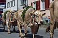
Almabtrieb at Mels in 2019.

See also
 In Spanish: Cantón de San Galo para niños
