
Jona facts for kids
Quick facts for kids
Jona
|
||
|---|---|---|
_-_Obersee_-_Etzel_Kulm_2010-10-21_16-39-50.JPG)
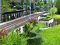
Jona in October 2010
|
||
|
||

Jona
Location in Switzerland

Jona
Location in Canton of St. Gallen
|
||
| Country | Switzerland | |
| Canton | St. Gallen | |
| District | See-Gaster | |
| Municipality | Rapperswil-Jona | |
| Area | ||
| • Total | 20.43 km2 (7.89 sq mi) | |
| Elevation | 409 m (1,342 ft) | |
| Population | ||
| • Total | 17,799 | |
| • Density | 871.22/km2 (2,256.4/sq mi) | |
| Postal code |
8645
|
|
| Localities | Bollingen, Busskirch, Curtiberg, Kempraten-Lenggis, Wagen, Wurmsbach | |
| Surrounded by | Altendorf (SZ), Bubikon (ZH), Eschenbach, Freienbach (SZ), Hombrechtikon (ZH), Kempraten, Lachen (SZ), Rapperswil, Rüti (ZH), Schmerikon, Tuggen (SZ), Wangen (SZ) | |

Jona was once a separate municipality in Switzerland. It was located in the See-Gaster district within the canton of St. Gallen. A canton is like a state or province in other countries.
On January 1, 2007, Jona joined with the nearby town of Rapperswil. They formed a new, larger municipality called Rapperswil-Jona. This means Jona is no longer a separate town on its own.
Life in Jona Before the Merger
Before it joined Rapperswil, Jona was a lively place. It had a population of nearly 18,000 people in 2006. The town covered an area of about 20.43 square kilometers.
Jona was located at an elevation of 409 meters above sea level. It was known for its beautiful surroundings near the Obersee, which is the upper part of Lake Zurich.
Parts of Jona
Jona included several smaller villages and areas. These included:
- Bollingen
- Busskirch
- Curtiberg
- Kempraten-Lenggis
- Wagen
- Wurmsbach
Many of these places still exist today as parts of Rapperswil-Jona.
What Jona Was Like
Jona was a place where people spoke German. It had its own postal code, 8645. The town was connected by train lines, making it easy for people to travel. The Jona river also flowed through the area, adding to its natural beauty.
Images for kids
-
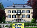
Grünfels estate
-
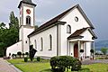
St. Martin Busskirch
-
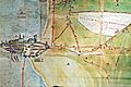
Jona and Rapperswil (1804)
-
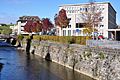
The Jona river in Jona, with the Stadthaus (city hall) to the left
-
Jona train station on the S-Bahn Zürich lines S5 and S15

_-_Busskirch_St_Martin_IMG_1941_ShiftN.jpg)

_-_Jona_IMG_1802.jpg)

