
Rapperswil-Jona facts for kids
Quick facts for kids
Rapperswil-Jona
|
||
|---|---|---|

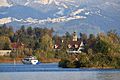
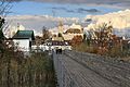
Rapperswil-Jona as seen from Kempraten-Lenggis, Jona to the left, Rapperswil and Seedamm to the right, Obersee (upper Lake Zürich) and Lachen (SZ) in the background (March 2010)
|
||
|
||

Rapperswil-Jona
Location in Switzerland

Rapperswil-Jona
Location in Canton of St. Gallen
|
||
| Country | Switzerland | |
| Canton | St. Gallen | |
| District | See-Gaster | |
| Area | ||
| • Total | 22.26 km2 (8.59 sq mi) | |
| Elevation | 409 m (1,342 ft) | |
| Highest elevation
(Eggwald, Wagen)
|
544 m (1,785 ft) | |
| Lowest elevation
(Busskirch)
|
407 m (1,335 ft) | |
| Population
(Dec 2020 )
|
||
| • Total | 27,483 | |
| • Density | 1,234.64/km2 (3,197.7/sq mi) | |
| Postal code |
8640
|
|
| Localities | Rapperswil, Jona, Bollingen, Busskirch, Curtiberg, Kempraten-Lenggis, Wagen | |
| Surrounded by | Altendorf (SZ), Bubikon (ZH), Eschenbach, Freienbach (SZ), Hombrechtikon (ZH), Lachen (SZ), Rüti (ZH), Schmerikon, Tuggen (SZ), Wangen (SZ) | |
| Twin towns | Aalborg (Denmark), Bagno di Romagna (Italy) | |

Rapperswil-Jona is a town in Switzerland. It is located in the canton of St. Gallen. This town was formed in 2007 when two separate towns, Rapperswil and Jona, joined together.
Besides Rapperswil and Jona, the town also includes smaller areas like Bollingen, Busskirch, Curtiberg, Kempraten-Lenggis, and Wagen. The main language spoken here is a local version of Swiss German.
Contents
About Rapperswil-Jona Today


On January 1, 2007, Rapperswil and Jona officially became one town. After this, Rapperswil-Jona became the second largest town in the canton of St. Gallen. Only the capital city, St. Gallen, is bigger.
Rapperswil-Jona is an important place for travel. Its main train station, Rapperswil railway station, connects many train lines. Boats also travel on Lake Zürich, linking Rapperswil with other towns.
Exploring Rapperswil's Main Sights
The town's main attractions are in the old part of Rapperswil. You can walk through its old streets and see many interesting places.
- Roses: Rapperswil is famous for its beautiful rose gardens.
- The Castle: Rapperswil Castle is a historic building with a clock tower.
- Wooden Bridge: A special wooden footbridge connects Rapperswil to Hurden across the lake. It was built in the same spot as a very old bridge.
- Monastery: There is also a Capuchin monastery in the town.
You can also find several churches and chapels. St. John's Church in Rapperswil was built around 1220. The Chapel St. Ursula in Kempraten is even older, from around 885. The St. Dionysius Chapel is a popular spot for visitors.
Other Interesting Places in the Area
Bollingen is known for the "Tower". This unique building was created by a famous psychologist named Carl Jung.
Kempraten is a very important place for history. Many old items from the Gallo-Roman era have been found there. It is one of the most important archaeological sites in the canton of St. Gallen.
History of Rapperswil-Jona
People have lived in the Rapperswil-Jona area for at least 5000 years. Scientists have found old tools and burial sites from ancient times.
How Rapperswil-Jona Grew
Rapperswil Castle was built around 1220 on a hill called Lindenhof. The town of Rapperswil started when a noble family moved there. Later, the Habsburg family took over the town. They built a wooden bridge across the lake in the 1300s.
Over time, the town became free and joined forces with the Swiss Confederation. Rapperswil became rich because it was in a good spot for trade. This allowed the town to have some freedom.
Later, under Napoleon, Rapperswil became part of a new canton. In 1803, it joined the canton of St. Gallen.
Circus Knie and Its Attractions
The famous Circus Knie moved its main office to Rapperswil in 1919. Today, the circus also runs the Knie's Kinderzoo, which is a zoo for children, and a Circus Museum.
Important Historical Sites
After a new causeway was built in 1878, a small chapel called Heilig Hüsli was left alone in the lake. In 2001, the old wooden bridge was rebuilt, making the chapel reachable again. This reconstructed wooden bridge is a very important historical site.
The area around the Seedamm has signs of very old settlements. These are called stilt house settlements because people built their homes on stilts over the water. These sites are part of a UNESCO World Heritage Site called "Prehistoric pile dwellings around the Alps."
Other important historical places include:
- The Chapel of St. Dionys.
- Schloss Rapperswil (Rapperswil Castle) with the Polish Museum.
- The Rathaus (Town Hall) of Rapperswil.
- The Roman settlement of Centum Prata at Kempraten.
- The Seedamm area and the historic wooden bridge.
Geography of Rapperswil-Jona
Rapperswil-Jona covers about 22.2 square kilometers (8.6 square miles). A large part of the land is used for farming, and another big part is covered by forests. The rest of the land has buildings, roads, or is made up of rivers and lakes.
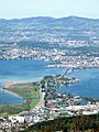
The town is located on the Seedamm, which is a natural land bridge. This land bridge was formed by a large Glacier during the ice age. The Seedamm divides Lake Zürich into two parts. The River Jona flows through the town and into the upper part of Lake Zürich.
People and Language
Most people in Rapperswil-Jona speak German. Italian is the second most common language, followed by Serbo-Croatian.
Many adults in Rapperswil-Jona have completed higher education. This means they have gone to college or a special school after high school.
Economy and Businesses
Rapperswil-Jona has a low unemployment rate, which means most people who want to work can find jobs. Many people work in the service industry, like shops and offices. There are also businesses in manufacturing and agriculture.
Some well-known companies located in Rapperswil-Jona include Geberit, LafargeHolcim, Obersee Nachrichten (a newspaper), and Radio Zürisee.
Getting Around Rapperswil-Jona
Train Travel

_-_Rapperswil-Jona_Stadtbus_der_VBZ_-_Bahnhof_2011-11-18_13-30-30.JPG)
Rapperswil-Jona has four train stations. The main one is Rapperswil railway station. From here, you can take trains to Zürich and other cities. Some trains use the Seedamm to cross the lake.
The other stations are Jona railway station, Kempraten railway station, and Blumenau railway station. These stations help people travel easily within the town and to nearby areas.
Bus Services
The town has a local bus service called Stadtbus Rapperswil-Jona. These buses help people get around the town and to nearby villages. There are several bus lines that cover different routes.
| Line | Route | Operator |
|---|---|---|
| 622 | Rapperswil Bahnhof – Cityplatz – Sonnenhof – Kreuz (Jona railway station) – Jona Center – St. Dyonis – Wagen – Eschenbach – St. Gallenkappel (– Ricken – Wattwil) | Schneider |
| 885 | Rapperswil Bahnhof – Cityplatz – Sonnenhof – Kempraten, Bahnhof – Schönau – Rüti ZH, Bahnhof – Wald ZH, Bahnhof – Goldingen – Atzmännig, Schutt | (VZO) |
| 991 | Rapperswil Bahnhof Süd – Kinderzoo – Grünfeld – Geberit (Blumenau railway station) – Jona, Bahnhof | Stadtbus Rapperswil-Jona (VZO) |
| 992 | Sonnenhof – Glärnischstrasse – Grünfeld – Geberit (Blumenau railway station) – Feldlistrasse – Jona, Bahnhof | Stadtbus Rapperswil-Jona (VZO) |
| 993 | Rapperswil Bahnhof – Cityplatz – Sonnenhof – Altersheim Meienberg – Vogelau (Jona railway station) – Tägernau | Stadtbus Rapperswil-Jona (VZO) |
| 994 | Rapperswil Bahnhof – Cityplatz – Sonnenhof – Kempraten, Bahnhof – Wohnheim Balm – Schönau – Jona, Bahnhof | Stadtbus Rapperswil-Jona (VZO) |
| 995 | Jona, Bahnhof – Jona Center – Hummelberg/Jona, Buechstrasse Ost | Schneider |
| 996 | Rapperswil Bahnhof Süd – Kinderzoo – Grünfeld – Geberit (Blumenau railway station) – Schachen/Feldlistrasse – Jona, Bahnhof | Stadtbus Rapperswil-Jona (VZO) |
Boat Services
Rapperswil has a harbor right next to its old town and train station. Boats from the Zürichsee-Schifffahrtsgesellschaft (ZSG) travel across Lake Zürich. They connect Rapperswil to Zürich and other towns along the lake. Many boats also stop at Ufenau island, which is near Rapperswil.
In the summer, there is also a ferry that crosses the upper part of Lake Zürich. This ferry connects Rapperswil with towns like Lachen and Altendorf on the other side of the lake.
Sports in Rapperswil-Jona

Rapperswil-Jona is home to two main sports teams:
- Ice Hockey: The SC Rapperswil-Jona Lakers are a professional ice hockey team. They play in the top league in Switzerland. Their home arena can hold 6,200 fans.
- Football: The FC Rapperswil-Jona is a football (soccer) team. It was started in 1928 and plays in a high league in Switzerland.
In 2006, Rapperswil-Jona also hosted the World Orienteering Championships. This is a sport where people use a map and compass to find their way through an area.
Town Partnerships
Rapperswil-Jona has special partnerships with two other towns in different countries. These are called "twin towns" or "sister cities."
|
Famous People from Rapperswil-Jona
Many notable people have come from Rapperswil and Jona. You can find more information about them in the articles for Rapperswil and Jona.
Images for kids
-
Wurmsbach Abbey
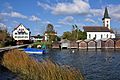
-
Chapel of St. Dionys
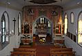
-
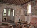
Inside the chapel
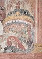
-
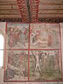
Paintings on the south wall of the chapel
-
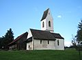
St. Martin Busskirch on Obersee (upper Lake Zürich)
-
Inside the medieval Parish church
-
Höllenrachen (Last Judgement) painting inside St. Martin
-
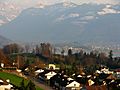
Meienberg hill
-
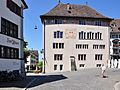
Rathaus (Town hall) of Rapperswil
-
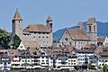
Schloss Rapperswil and Stadtpfarrkirche (St. John's church)
-
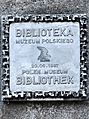
Polish Museum at the Schloss
-
Seedamm bridge across the lake
-
Reconstruction of the original wooden bridge from c. 1525 BC between Rapperswil and Hurden
-
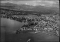
Aerial view (1954)
-
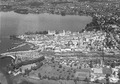
Aerial view (1962)


_-_Busskirch_St_Martin_IMG_2217_ShiftN.jpg)
_-_Busskirch_St_Martin_IMG_2206_ShiftN.jpg)
_-_Busskirch_St_Martin_IMG_4774_ShiftN.jpg)
_-_Lenggis_Spitzewies_IMG_4965.JPG)


<mapframe text="Rapperswil-Jona" width="400" height="400" zoom="13" latitude="47.226" longitude="8.8345"> { "type": "FeatureCollection", "features": [ { "type": "Feature", "properties": { "title": "Wurmsbach Abbey", "marker-symbol": "-number", "marker-color": "302060" }, "geometry": { "type": "Point", "coordinates": [ 8.8646, 47.2195 ] }}, { "type": "Feature", "properties": { "title": "Chapel of St. Dionys", "marker-symbol": "-number", "marker-color": "302060" }, "geometry": { "type": "Point", "coordinates": [ 8.86141, 47.22737 ] }}, { "type": "Feature", "properties": { "title": "St. Martin Busskirch", "marker-symbol": "-number", "marker-color": "302060" }, "geometry": { "type": "Point", "coordinates": [ 8.83344, 47.21703 ] }}, { "type": "Feature", "properties": { "title": "Rathaus Rapperswil", "marker-symbol": "-number", "marker-color": "302060" }, "geometry": { "type": "Point", "coordinates": [ 8.81641, 47.22636 ] }}, { "type": "Feature", "properties": { "title": "Schloss Rapperswil, Polish Museum", "marker-symbol": "-number", "marker-color": "302060" }, "geometry": { "type": "Point", "coordinates": [ 8.81553, 47.22736 ] }}, { "type": "Feature", "properties": { "title": "Seedamm", "marker-symbol": "-number", "marker-color": "302060" }, "geometry": { "type": "Point", "coordinates": [ 8.81032, 47.22116 ] }}, { "type": "Feature", "properties": { "title": "Holzbrücke Rapperswil-Hurden", "marker-symbol": "-number", "marker-color": "302060" }, "geometry": { "type": "Point", "coordinates": [ 8.81433, 47.22163 ] }} ] } </mapframe>

See also
 In Spanish: Rapperswil-Jona para niños
