
St. Gallenkappel facts for kids
Quick facts for kids
St. Gallenkappel
|
||
|---|---|---|
_copy.jpg)
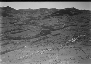
St. Gallenkappel village
|
||
|
||

St. Gallenkappel
Location in Switzerland

St. Gallenkappel
Location in Canton of St. Gallen
|
||
| Country | Switzerland | |
| Canton | St. Gallen | |
| District | See-Gaster | |
| Area | ||
| • Total | 19.46 km2 (7.51 sq mi) | |
| Elevation | 595 m (1,952 ft) | |
| Population
(Dec 2011)
|
||
| • Total | 1,835 | |
| • Density | 94.30/km2 (244.23/sq mi) | |
| Postal code |
8735
|
|
| Surrounded by | Ernetschwil, Eschenbach, Goldingen, Mosnang, Uznach, Wattwil | |

St. Gallenkappel was once a small town, or municipality, in Switzerland. It was located in the canton of St. Gallen. On January 1, 2013, St. Gallenkappel joined with another town called Goldingen. Both became part of the larger municipality of Eschenbach.
Contents
History of St. Gallenkappel
St. Gallenkappel was first mentioned in old writings in 1275. Back then, it was called S. Galli capella. Later, in 1425, people called it bi Sant Gallencappel. Even today, in the local Swiss German language, it's known as Chappele.
How St. Gallenkappel Got Its Name
The town is located along two very old paths. These paths were used for trade and also by people going on pilgrimages. One path came from Toggenburg, and the other from Hummelwald to Lake Zurich. It's believed that a small church, called a chapel, was built here in the 800s. This chapel was likely named after a saint called St. Gallus. This old chapel is probably why the village got its name. The word "Kappel" means "chapel."
A Protest for Freedom
In 1830, something important happened in St. Gallenkappel. On December 10, people gathered to protest. They were unhappy about losing their freedoms. This was after a time when Switzerland had been controlled by other powers. The people wanted more say in how their canton, or state, was run.
They asked for two main changes. First, they wanted a fairer way to choose people for their local government. They felt that the main city of St. Gallen had too much power. Second, they wanted a way to change their canton's constitution. At that time, it was very hard for citizens to suggest new laws or changes.
These protests in St. Gallenkappel and other towns were peaceful. The government listened to the people's demands. This led to a period called the "Regeneration." Eventually, in 1848, Switzerland became a federal state. This meant that power was shared more fairly across the country.
Geography and Landscape
St. Gallenkappel covered an area of about 19.5 square kilometers (about 7.5 square miles). A large part of this land, almost 60%, was used for farming. About 35% was covered by forests. The rest of the land had buildings, roads, or was non-productive, like rivers.
The former town is located southwest of the Ricken Pass. This area is between the Linth valley and a mountain called Tweralpspitz. The Tweralpspitz is about 1,332 meters (4,370 feet) high. St. Gallenkappel included the main village and smaller settlements called hamlets. These hamlets were Bezikon, Rüeterswil, and Walde.
Coat of Arms
The coat of arms for St. Gallenkappel is quite special. It shows St. Gallus on one side. He is holding a book and a staff. On the other side, there is a small chapel. This design is an example of canting arms. This means the pictures on the shield help spell out the name of the town. "St. Gallen" comes from Saint Gallus, and "Kappelle" (chapel) comes from the chapel.
People of St. Gallenkappel
In 2011, St. Gallenkappel had a population of 1,835 people. Most people living there spoke German. A smaller number spoke Albanian or Serbo-Croatian.
Age Groups in the Community
In 2000, the population was divided into different age groups:
- Children (0-9 years old): 14.8%
- Teenagers (10-19 years old): 16.6%
- Young adults (20-29 years old): 11.2%
- Adults (30-59 years old): 41.1%
- Seniors (60-99 years old): 16.2%
Education in St. Gallenkappel
Many adults in St. Gallenkappel have completed a good level of education. About 66.9% of people aged 25 to 64 had finished either high school or gone on to higher education. This could be a university or a specialized college.
The historical population of St. Gallenkappel changed over the years:
| year | population |
|---|---|
| 1850 | 1,229 |
| 1900 | 1,008 |
| 1950 | 1,110 |
| 2000 | 1,719 |
Economy and Jobs
In 2007, the unemployment rate in St. Gallenkappel was very low, at just 1.02%. This means almost everyone who wanted a job had one.
The jobs in St. Gallenkappel were divided into three main types:
- Primary sector: This includes jobs like farming and forestry. In 2005, 178 people worked in this area.
- Secondary sector: This includes jobs in manufacturing and construction. In 2005, 124 people worked in this area.
- Tertiary sector: This includes jobs in services, like shops, schools, and healthcare. In 2005, 215 people worked in this area.
Many people who lived in St. Gallenkappel also worked in other towns. In 2000, 555 residents traveled outside the town for work. At the same time, 122 people came into St. Gallenkappel for their jobs.
Religion
According to the 2000 census, most people in St. Gallenkappel were Roman Catholic. About 73.3% of the population belonged to the Roman Catholic Church. Another 15.2% belonged to the Swiss Reformed Church. A small number of people belonged to other Christian churches or were Islamic. About 5.9% of the population did not belong to any church.
Images for kids
-
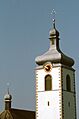
The bell tower of the St. Laurentius and St. Gallus Parish Church
-
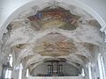
The beautiful Baroque church in St. Gallenkappel


The Baroque parish church "St. Laurentius and St. Gallus" was built between 1754 and 1764. It was designed by the architect Jakob Grubenmann. The paintings inside were created by the Baroque painter Joseph Ignaz Weiss.

See also
 In Spanish: Sankt Gallenkappel para niños
