
Cabezas, Fajardo, Puerto Rico facts for kids
Quick facts for kids
Cabezas
|
|
|---|---|
|
Barrio
|
|

Las Croabas, Cabezas
|
|

Location of Cabezas within the municipality of Fajardo shown in red
|
|

Cabezas, Fajardo, Puerto Rico
Location in Caribbean
|
|
| Commonwealth | |
| Municipality | |
| Area | |
| • Total | 73.48 sq mi (190.3 km2) |
| • Land | 3.01 sq mi (7.8 km2) |
| • Water | 70.47 sq mi (182.5 km2) |
| Elevation | 0 ft (0 m) |
| Population
(2010)
|
|
| • Total | 1,339 |
| • Density | 449.3/sq mi (173.5/km2) |
| Source: 2010 Census | |
| Time zone | UTC−4 (AST) |
| ZIP Code |
00738
|
Cabezas is a special kind of neighborhood, called a barrio, located in the town of Fajardo, Puerto Rico. In 2010, about 1,339 people lived here.
A part of Cabezas is called the Croabas Community. It's home to about 1,053 people. This area is known for fishing and is a popular spot where boats leave for tours.
A Look at Cabezas's Past
Puerto Rico became a territory of the United States after the Spanish–American War. This happened in 1898, following a peace agreement called the Treaty of Paris of 1898.
In 1899, the United States government counted everyone living in Puerto Rico. This count is called a census. The census showed that Cabezas and a nearby barrio called Demajagua had a combined population of 1,168 people.
The population of Cabezas has changed over the years:
| Historical population | |||
|---|---|---|---|
| Census | Pop. | %± | |
| 1910 | 789 | — | |
| 1920 | 724 | −8.2% | |
| 1930 | 771 | 6.5% | |
| 1940 | 557 | −27.8% | |
| 1950 | 742 | 33.2% | |
| 1980 | 1,216 | — | |
| 1990 | 1,211 | −0.4% | |
| 2000 | 1,465 | 21.0% | |
| 2010 | 1,339 | −8.6% | |
| U.S. Decennial Census 1899 (shown as 1900) 1910-1930 1930-1950 1980-2000 2010 |
|||
Gallery
-
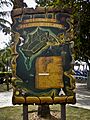
Welcome to Palomino Island in Cabezas
-
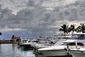
Pier at Cabezas
-
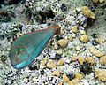
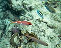
Tropical fish at Cabezas
-
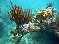
Marine life in Cabezas
-
Tropical fish at Cabezas


See also
 In Spanish: Cabezas (Fajardo) para niños
- List of communities in Puerto Rico
