Cacao Bajo facts for kids
Quick facts for kids
Cacao Bajo
|
|
|---|---|
|
Barrio
|
|

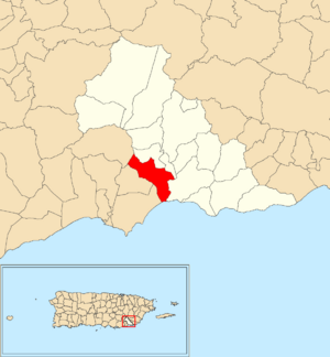
Location of Cacao Bajo within the municipality of Patillas shown in red
|
|
| Commonwealth | |
| Municipality | |
| Area | |
| • Total | 2.63 sq mi (6.8 km2) |
| • Land | 2.42 sq mi (6.3 km2) |
| • Water | 0.21 sq mi (0.5 km2) |
| Elevation | 135 ft (41 m) |
| Population
(2010)
|
|
| • Total | 1,437 |
| • Density | 593.8/sq mi (229.3/km2) |
| Source: 2010 Census | |
| Time zone | UTC−4 (AST) |
Cacao Bajo is a special kind of neighborhood, called a barrio, located in the town of Patillas, Puerto Rico. In 2010, about 1,437 people lived there. It's a small but important part of the Patillas area.
Contents
A Look at Cacao Bajo's History
Puerto Rico became a territory of the United States after the Spanish–American War in 1898. This happened because of a peace agreement called the Treaty of Paris of 1898.
In 1899, the U.S. government took a count of all the people in Puerto Rico. This count is called a census. The census found that 928 people lived in the combined areas of Cacao Bajo and a nearby barrio called Quebrada Arriba.
How Cacao Bajo's Population Changed
The number of people living in Cacao Bajo has changed over many years. Here's a look at the population from different census counts:
| Historical population | |||
|---|---|---|---|
| Census | Pop. | %± | |
| 1910 | 598 | — | |
| 1920 | 565 | −5.5% | |
| 1930 | 405 | −28.3% | |
| 1940 | 1,112 | 174.6% | |
| 1950 | 1,452 | 30.6% | |
| 1980 | 1,718 | — | |
| 1990 | 1,906 | 10.9% | |
| 2000 | 1,425 | −25.2% | |
| 2010 | 1,437 | 0.8% | |
| U.S. Decennial Census 1899 (shown as 1900) 1910-1930 1930-1950 1980-2000 2010 |
|||
Understanding Cacao Bajo's Sectors
Barrios like Cacao Bajo are often divided into even smaller areas. These smaller parts are called sectores (say: sek-TOH-res), which means "sectors" in English. Think of them as smaller neighborhoods within the barrio.
These sectors can have different names depending on what they are like. Some are just called "sector," while others might be "urbanización" (a planned housing area) or "reparto" (a land division).
Main Sectors in Cacao Bajo
Here are some of the important sectors you can find in Cacao Bajo barrio:
- Carretera 3
- Carretera 184
- Carretera 755
- Sector Ancones Sifón
- Sector La Herradura
- Sector Los Pompos
- Sector Margote
- Sector Obén
- Sector Raja Larga
- Sector Sabana
- Sector Seboruco
- Sector Túnel Sabana
- Sector Yaurel Chiquito
- Urbanización Estancias de Aurora
- Urbanización Las Violetas
See also
 In Spanish: Cacao Bajo para niños
- List of communities in Puerto Rico
- List of barrios and sectors of Patillas, Puerto Rico
 | Bayard Rustin |
 | Jeannette Carter |
 | Jeremiah A. Brown |


