Cactus Range facts for kids
Quick facts for kids Cactus Range |
|
|---|---|

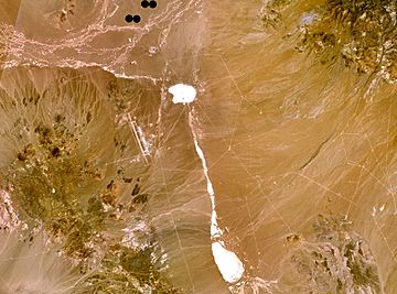
The range is the green/brown area in the southwest part of the image. The Tonopah Test Range Airport lies on the northwest flank of the range.
|
|
| Highest point | |
| Peak | Antelope Peak |
| Elevation | 2,300 m (7,500 ft) |
| Geography | |
| Country | United States |
| State | Nevada |
| District | Nye County |
| Range coordinates | 37°40′53.776″N 116°49′33.233″W / 37.68160444°N 116.82589806°W |
| Topo map | USGS Cactus Spring |
The Cactus Range is a small group of mountains in Nye County, Nevada. These mountains are found southwest of an area called Cactus Flat. They are also north of Pahute Mesa. The town of Goldfield is about 23 mi (37 km) to the west. This mountain range is part of a special area. It is inside the Tonopah Test Range, which is a restricted zone.
Contents
Discover the Cactus Range!
The Cactus Range is a cool place to learn about Nevada's geography. It might be small, but it has some interesting features. This area is known for its unique desert plants.
Where is the Cactus Range Located?
This mountain range is in the state of Nevada, in a county called Nye County. It sits between a flat area called Cactus Flat and a high, flat landform known as Pahute Mesa. The range is also quite close to the Tonopah Test Range. This is a special area used for testing and research.
What are the Highest Points?
The Cactus Range has several peaks, which are the highest points of the mountains. Here are some of the important ones:
- Antelope Peak is 7,500 ft (2,300 m) tall. Its location is 37°37.59′N 116°45.35′W / 37.62650°N 116.75583°W.
- Cactus Peak reaches 7,477 ft (2,279 m) high. You can find it at 37°46.97′N 116°52.69′W / 37.78283°N 116.87817°W.
- Urania Peak stands at 7,333 ft (2,235 m). Its coordinates are 37°41.98′N 116°50.10′W / 37.69967°N 116.83500°W.
- Mount Helen is 7,120 ft (2,170 m) tall. It is located at 37°30.39′N 116°44.46′W / 37.50650°N 116.74100°W.
Why is it Called Cactus Range?
The name "Cactus Range" is very simple! It was given this name because there are many types of cacti plants growing in the area. These spiky desert plants are a common sight around the mountains.
 | Charles R. Drew |
 | Benjamin Banneker |
 | Jane C. Wright |
 | Roger Arliner Young |


