Cadet, Missouri facts for kids
Quick facts for kids
Cadet, Missouri
|
|
|---|---|

Location of Cadet, Missouri
|
|
| Country | United States |
| State | Missouri |
| County | Washington |
| Elevation | 801 ft (244 m) |
| Time zone | UTC-6 (Central (CST)) |
| • Summer (DST) | UTC-5 (CDT) |
| ZIP code |
63630
|
| Area code(s) | 573 |
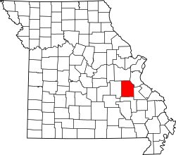
Cadet is a small community in Washington County, Missouri, in the United States. It's not a city with its own government, but a place where people live and work. You can find Cadet in eastern Washington County, along Missouri Route 47. It's located between the towns of Old Mines and Bonne Terre. Cadet is about 6 miles (10 km) northeast of Potosi.
History of Cadet
Mining in Cadet's Past
Cadet is located in an area famous for mining. Long ago, people mined for lead and barite here. These minerals were very important. Cadet was known for having one of the last old-style furnaces. This furnace used logs and ash to process the mined materials. It was still in use as late as 1864.
How Cadet Started
The community of Cadet began to grow when the railroad reached this spot. The railroad made it easier to transport goods and people. A post office opened in Cadet in 1859. This helped the community connect with other places. No one knows for sure how Cadet got its name.
The 1911 Tornado
On April 14, 1911, a very strong tornado hit Cadet. The tornado was about three-quarters of a mile wide. It destroyed most of the buildings in the town. Many homes on nearby farms were also damaged. About 500 people lived in the town at that time. Including the surrounding farms, about 3,000 people lost their homes. Twelve people were injured, and four people died. The community worked hard to rebuild after this event.
 | Precious Adams |
 | Lauren Anderson |
 | Janet Collins |

