Caher Mountain (Cork) facts for kids
Quick facts for kids Caher Mountain |
|
|---|---|
| Cathair | |

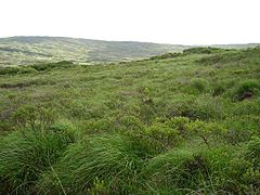
Very rough hillside and bog running up to the summit of Caher Mountain
|
|
| Highest point | |
| Elevation | 338 m (1,109 ft) |
| Prominence | 143 m (469 ft) |
| Geography | |
| Location | County Cork, Ireland |
| Parent range | Sheep's Head peninsula |
Caher Mountain is a special hill found in County Cork, Ireland. It stands 338 metres (about 1,109 feet) tall. The name Caher comes from an old Irish word, Cathair, which means "stone ring-fort." This suggests there might have been an ancient stone fort here long ago! From the top, you can see amazing views of the Sheep's Head peninsula. It's located just west of a small village called Kilcrohane.
Contents
Where is Caher Mountain Located?
Caher Mountain is found on the beautiful Sheep's Head peninsula. It's about 15 kilometres (9 miles) from the very end of the peninsula. The mountain is also around 4 kilometres (2.5 miles) west of the village of Kilcrohane.
Nearby Peaks
Caher Mountain has a neighbour called Seefin. Seefin is a bit taller at 345 metres (1,132 feet). It is located about 5 kilometres (3 miles) to the northeast.
How to Reach the Summit
You can easily walk to the top of Caher Mountain. There's a good starting point from a lay-by. This spot is about 1.5 kilometres (1 mile) above the village. It makes for a nice, easy hike for adventurers like you!
What Can You See from Caher Mountain?
When the weather is clear, the views from Caher Mountain are truly incredible. You can see far across the landscape.
Distant Views
On a sunny day, you might even spot Dursey Island. This island is quite a distance away! You can also see parts of the Iveragh Peninsula. These amazing sights make the climb to Caher Mountain totally worth it.
 | Frances Mary Albrier |
 | Whitney Young |
 | Muhammad Ali |


