Cahermore ringfort facts for kids
|
Cathair Mór
|
|

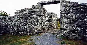
The entry with restored lintel in 2006
|
|
| Alternative name | Caher Mór (also Ballyallaban stone fort) |
|---|---|
| Location | Parish of Rathborney, the Burren |
| Region | Ireland |
| Coordinates | 53°05′08″N 9°09′51″W / 53.085432°N 9.164229°W |
| Type | ringfort |
| History | |
| Material | limestone |
| Periods | unknown, but inhabited in the 14th/15th century |
| Site notes | |
| Public access | Yes |
| Reference no. | 648 |
Cahermore ringfort, also known as Cathair Mór or Ballyallaban stone fort, is an ancient circular stone fort. It is located south of Ballyvaughan in the beautiful the Burren area of County Clare, Ireland. This important site is protected as a National Monument.
Where is Cahermore Ringfort?
This ancient fort is easy to find! It sits right beside the R480 road. This road connects the village of Ballyvaughan and Leamaneh Castle. The fort is in a place called Ballyallaban, within the Rathborney area.
What Does Cahermore Look Like?
The walls of Cahermore ringfort are very strong. They are up to 9 feet thick and 9 feet high! These walls are made of large, carefully placed stones. Smaller stones and rubble fill the space between the outer and inner layers.
Inside the fort, you can see parts of old buildings. These are thought to be from the late medieval period. Near the main entrance, there are special "guard chambers." These small rooms suggest that important people lived here long ago.
The official national monument number 648 actually includes two separate forts. One is the stone fort of Cahermore. The other is a nearby earthen fort called Ballyallaban ringfort.
Digging Up the Past: Excavation
A small archaeological dig happened at Cahermore in the late 1990s. This was after a large stone, called a lintel, fell down at the entrance. A lintel is a horizontal stone that spans an opening, like a doorway.
During the dig, archaeologists found a coin from the year 1690. This helps us learn about when people might have been using the fort.
The National Monuments Service explains more about the excavation. It happened in June 1999 because the entrance was blocked. The fallen lintel was also a problem. The dig showed that the structures around the entrance were added later. They were built in the 14th or 15th century.
Scientists used radiocarbon dating on a scallop shell found under the foundations. This test showed the shell was from around 1308 AD. This helps us understand when the new parts were built. The lintel was put back in place, and the entrance was made strong again in 2001.
 | Toni Morrison |
 | Barack Obama |
 | Martin Luther King Jr. |
 | Ralph Bunche |


