Cahone, Colorado facts for kids
Quick facts for kids
Cahone, Colorado
|
|
|---|---|

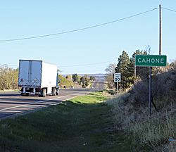
Entering Cahone from the south on U.S. Highway 491
|
|
| Country | |
| State | |
| County | Dolores County |
| Established | About 1912 |
| Elevation | 6,680 ft (2,040 m) |
| Time zone | UTC-7 (MST) |
| • Summer (DST) | UTC-6 (MDT) |
| ZIP Code |
81320
|
| GNIS feature ID | 176613 |
Cahone is a small community in western Dolores County, Colorado, United States. It's not an official town with its own government, which is why it's called an unincorporated community. You can find Cahone about 9 miles southeast of Dove Creek, right along U.S. Highway 491.
In Cahone, you'll find a post office and a large farm that grows and processes beans. There's also a small bar and grill if you're looking for a bite to eat. However, don't expect to find a grocery store, gas station, or hotels here.
A Look at Cahone's Past
Cahone has an interesting history, going back much further than its modern settlement.
Ancient Roots: The Ansel Hall Ruin
Long before Cahone was established, people lived in this area. The Ansel Hall Ruin, also known as the Cahone Ruin, is an ancient settlement. It was home to a group of people called the North San Juan pueblo from about 1000 to 1499 AD. This important historical site has been recognized on the National Register of Historic Places since 1997.
How Cahone Got Its Name
The modern community of Cahone was started around 1912. The name "Cahone" was chosen by Bert Ballenger, who later became the town's first postmaster. He named it after a nearby canyon called El Cajón in Spanish. This Spanish phrase means little box. The Cahone Post Office officially opened its doors on May 21, 1916.
 | William M. Jackson |
 | Juan E. Gilbert |
 | Neil deGrasse Tyson |


