Caira County facts for kids
Quick facts for kids CairaNew South Wales |
|||||||||||||||
|---|---|---|---|---|---|---|---|---|---|---|---|---|---|---|---|

Location in New South Wales
|
|||||||||||||||
|
|||||||||||||||
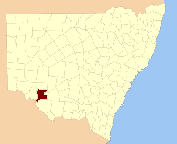
Caira County is a special area in New South Wales, Australia. It's one of 141 "cadastral divisions." Think of these as old-fashioned land divisions used for maps and property records.
This county is home to the town of Balranald. It sits in a unique spot where the Murrumbidgee River meets the Murray River. It's also near where the Lachlan River joins the Murrumbidgee. Much of the area is part of the "Lowbidgee Floodplain," which is a flat area that can get flooded by rivers. The name "Caira" comes from a word used by the local Aboriginal people.
Exploring Caira County
Caira County is located in the western part of New South Wales. It's a region known for its rivers and flat lands. The county's boundaries are defined by these important waterways.
Rivers and Floodplains
The Murrumbidgee River and Murray River are major rivers in Australia. They are very important for the environment and farming in the region. The Lachlan River also plays a role in shaping the landscape. The Lowbidgee Floodplain is a large, flat area. It's formed by the rivers overflowing their banks, which makes the soil very rich. This area is important for wildlife and agriculture.
What is a Cadastral Division?
A "cadastral division" is a way of dividing land. It's used for legal purposes, like owning property or drawing official maps. These divisions help governments keep track of land ownership and boundaries. They are not the same as modern local government areas, but they are still used for some records.
 | DeHart Hubbard |
 | Wilma Rudolph |
 | Jesse Owens |
 | Jackie Joyner-Kersee |
 | Major Taylor |

