Cairo, Missouri facts for kids
Quick facts for kids
Cairo, Missouri
|
|
|---|---|
|
Village
|
|

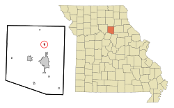
Location of Cairo, Missouri
|
|
| Country | United States |
| State | Missouri |
| County | Randolph |
| Area | |
| • Total | 0.30 sq mi (0.78 km2) |
| • Land | 0.30 sq mi (0.78 km2) |
| • Water | 0.00 sq mi (0.00 km2) |
| Elevation | 860 ft (260 m) |
| Population
(2020)
|
|
| • Total | 205 |
| • Density | 683.33/sq mi (263.76/km2) |
| Time zone | UTC-6 (Central (CST)) |
| • Summer (DST) | UTC-5 (CDT) |
| ZIP code |
65239
|
| Area code(s) | 660 |
| FIPS code | 29-10360 |
| GNIS feature ID | 2397523 |
Cairo is a small village located in Randolph County, Missouri, in the United States. In 2020, about 205 people lived there. It's important to know that Cairo, Missouri, is pronounced "Kay-row," which is different from the famous city in Egypt.
Contents
History of Cairo, Missouri
How Cairo Got Its Name
The village of Cairo was first started in 1858. Back then, it had a different name: "Fairview." Later, its name was changed to Cairo. It's believed that the village was named after the city of Cairo, Egypt. This name might have come directly from Egypt or perhaps through another town called Cairo, Illinois. A post office has been open in Cairo, Missouri, since 1860.
Ancient Site Near Cairo
An important historical place near Cairo is the Mitchell Petroglyph Archeological Site. A petroglyph is a drawing or carving made on a rock by ancient people. This site was recognized as a special historical place in 1969. It was added to the National Register of Historic Places, which is a list of places important to the history of the United States.
Geography of Cairo
Where is Cairo Located?
Cairo is a small village in Missouri. According to the United States Census Bureau, which is a government agency that collects information about people and places, the village covers a total area of about 0.31 square miles (0.78 square kilometers). All of this area is land; there are no large bodies of water within the village limits.
Population of Cairo
How Many People Live in Cairo?
The population of Cairo has changed over the years. Here's a quick look at how many people have lived in the village during different census years:
| Historical population | |||
|---|---|---|---|
| Census | Pop. | %± | |
| 1880 | 100 | — | |
| 1900 | 173 | — | |
| 1910 | 220 | 27.2% | |
| 1920 | 221 | 0.5% | |
| 1930 | 250 | 13.1% | |
| 1940 | 254 | 1.6% | |
| 1950 | 264 | 3.9% | |
| 1960 | 210 | −20.5% | |
| 1970 | 248 | 18.1% | |
| 1980 | 315 | 27.0% | |
| 1990 | 282 | −10.5% | |
| 2000 | 293 | 3.9% | |
| 2010 | 292 | −0.3% | |
| 2020 | 205 | −29.8% | |
| U.S. Decennial Census | |||
Cairo's Population in 2010
During the census in 2010, there were 292 people living in Cairo. These people lived in 106 different homes, and 83 of these were families. The village had about 941.9 people per square mile. There were also 125 housing units, which are places where people can live.
The average age of people in Cairo in 2010 was 35 years old. About 31.2% of the people were under 18 years old. Also, 15.8% of the people were 65 years old or older. The population was almost evenly split between males (48.3%) and females (51.7%).
See also
 In Spanish: Cairo (Misuri) para niños
 | James B. Knighten |
 | Azellia White |
 | Willa Brown |

