
California Historical Landmarks in Humboldt County facts for kids
California is full of amazing historical places, and Humboldt County in Northern California has many special ones! These places are called California Historical Landmarks. They are important spots that tell us about California's past, like where the first oil wells were drilled or where important towns were founded. Learning about these landmarks helps us understand the history of this beautiful area.
Contents
What are California Historical Landmarks?
California Historical Landmarks are places, buildings, or districts that have been officially recognized as very important to the history of California. They are chosen because they played a big role in events, people, or developments that shaped the state. When a place becomes a landmark, it often gets a special plaque or marker so everyone can learn about its history.
These landmarks help us remember and celebrate the stories of the past. They can be anything from old forts and buildings to natural sites or even entire towns. They are like clues that help us piece together the exciting history of California.
Famous Landmarks in Humboldt County
Humboldt County is home to many interesting historical landmarks. Each one has a unique story to tell about the region's past.
Arcata and Mad River Railroad
The Arcata and Mad River Railroad Company is a landmark located in Blue Lake. It was an important part of transportation in the area. This railroad helped move goods and people, connecting communities. It played a key role in the growth of Humboldt County.
California's First Drilled Oil Wells
In Petrolia, you can find the site of California's First Drilled Oil Wells. This landmark marks where oil was first successfully drilled in California. It was a big step for the state's energy industry. This discovery changed how people lived and worked.
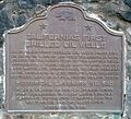
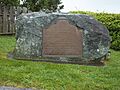
Camp Curtis
Camp Curtis is located in Arcata. This site was once a military camp. It was used during a time when the area was developing. Military camps like this one were important for keeping peace and order. They also helped with exploration and settlement.
Centerville Beach Cross
The Centerville Beach Cross is found near Ferndale. This landmark is a cross placed on a cliff overlooking the ocean. It remembers a sad event where many lives were lost. It serves as a memorial and a reminder of the area's maritime history.
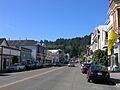
City of Eureka
The entire City of Eureka is recognized as a historical landmark. Eureka is a major city in Humboldt County. It has a rich history as a port town. Many old buildings and areas in Eureka show its past. It was a center for logging and shipping.
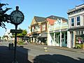
Ferndale
The town of Ferndale is also a historic district. It is famous for its beautiful Victorian architecture. Many of its buildings are well-preserved. Walking through Ferndale feels like stepping back in time. It is often called "Victorian Village."
Fort Humboldt
Fort Humboldt State Historic Park in Eureka was once a United States Army fort. It was active in the mid-1800s. The fort played a role in conflicts between settlers and Native Americans. It also served as a base for explorers.
Humboldt Harbor Historical District
The Humboldt Harbor Historical District is located in Eureka. This district highlights the importance of Humboldt Bay. The bay was a vital port for trade and travel. It helped connect Humboldt County to the rest of the world.
Jacoby Building
The Jacoby Building is in Arcata. This historic building was once a storehouse. It was a central place for business in early Arcata. The building shows the architectural style of its time. It is a reminder of Arcata's early commercial life.
The Old Arrow Tree
Near Korbel, you can find The Old Arrow Tree. This landmark is a special tree. It was important to the local Native American tribes. They used it for various purposes. It represents their long history in the area.
Old Indian Village of Tsurai
The Old Indian Village of Tsurai is located in Trinidad. This site was once a thriving village of the Yurok people. It shows how Native Americans lived in the area for thousands of years. It is a very important archaeological site.
Town of Trinidad
The Town of Trinidad is recognized as a historic district. Trinidad is a small coastal town. It has a long history as a fishing village and port. Its beautiful bay and historic buildings make it a special place.
Trinidad Head
Trinidad Head is a prominent landmark near Trinidad. It is a large, rocky headland. It was an important navigation point for ships. It offers amazing views of the Pacific Ocean. It also has historical markers.
Images for kids
-
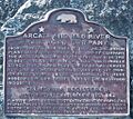
Plaque for the Arcata and Mad River Rail Road Company.
-
The site of California's first drilled oil wells in Petrolia.
-
A plaque marking the location of Camp Curtis in Arcata.
-
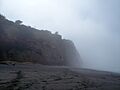
The Centerville Beach Cross overlooking the ocean.
-
Old Town Eureka, part of the City of Eureka landmark.
-
Historic buildings in Ferndale, a recognized historic district.
-
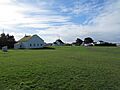
A building at Fort Humboldt State Historic Park.
-
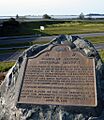
Plaque for the Humboldt Harbor Historical District.
-
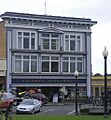
The historic Jacoby Building in Arcata.
-
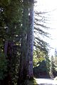
The Old Arrow Tree near Korbel.
-
Plaque for the Old Indian Village of Tsurai.
-
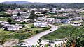
The scenic town of Trinidad, a historic district.
-
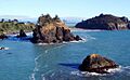
Trinidad Head, a significant coastal landmark.


