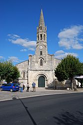
Cambes, Gironde facts for kids
Quick facts for kids
Cambes
|
||
|---|---|---|
 |
||
|
||
| Country | France | |
| Region | Nouvelle-Aquitaine | |
| Department | Gironde | |
| Arrondissement | Bordeaux | |
| Canton | Créon | |
| Intercommunality | Portes de l'Entre Deux Mers | |
| Area
1
|
5.34 km2 (2.06 sq mi) | |
| Population
(Jan. 2019)
|
1,732 | |
| • Density | 324.3/km2 (840.0/sq mi) | |
| Time zone | UTC+01:00 (CET) | |
| • Summer (DST) | UTC+02:00 (CEST) | |
| INSEE/Postal code |
33084 /33880
|
|
| Elevation | 2–86 m (6.6–282.2 ft) (avg. 23 m or 75 ft) |
|
| 1 French Land Register data, which excludes lakes, ponds, glaciers > 1 km2 (0.386 sq mi or 247 acres) and river estuaries. | ||
Cambes is a small town or village in France. It is officially called a commune. A commune is like a local government area. It is found in the Aquitaine region. This region is in the Gironde department. Cambes is located in the southwest part of France.
About Cambes
Cambes is a commune in the Gironde department. This department is part of the Aquitaine region. It is in the southwest of France. The town is located near the city of Bordeaux.
Geography of Cambes
Cambes is situated on the right bank of the Garonne River. The land around Cambes varies in height. The lowest point is 2 meters above sea level. The highest point is 86 meters above sea level. The average elevation is about 23 meters.
Population and Administration
As of January 2019, Cambes had a population of 1,732 people. The mayor of Cambes is Bernard Cuartero. He served from 2008 to 2014. The commune is part of the Créon canton. It is also part of the Bordeaux arrondissement.
See also
 In Spanish: Cambes (Gironda) para niños


