
Cambridgeshire Lodes facts for kids
Quick facts for kids Cambridgeshire Lodes |
|
|---|---|

The pumping station and flood gates at the end of Bottisham Lode
|
|
| Specifications | |
| Locks | 2 |
| Status | Some Navigable |
| Navigation authority | Environment Agency |
| History | |
| Original owner | Drainage Commissioners |
| Date of act | none |
| Date of first use | Roman period onwards |
| Geography | |
| Connects to | River Cam, River Great Ouse |
The Cambridgeshire Lodes are a group of waterways in Cambridgeshire, England. People believe they were built by the Romans. These waterways are like small canals.
Bottisham, Swaffham Bulbeck, Reach, Burwell, Wicken, and Monks Lodes all connect to the River Cam. Soham Lode connects to the River Great Ouse. In the past, boats could travel on all of them. Today, some are no longer officially open for boats.
Bottisham Lode was used by boats throughout the 1800s. Its flood gates were updated in 2001. However, a sign now says "No unauthorised vessels." Swaffham Bulbeck Lode is not easy to use for boats anymore. This is because some lock gates were removed or changed.
Reach Lode is quite deep. This is because the land around it has sunk over time. The banks have been built up to keep the water in. A special gate allows boats up to 63 feet (19 metres) long to use it.
Burwell Lode is a branch of Reach Lode and is also deep. Boats were built and fixed in Burwell until 1936. The lode was used for business until 1963. Wicken Lode is another branch of Reach Lode. It was important for carrying peat and sedge (a type of grass). It flows through Wicken Fen, a very old nature reserve. The National Trust bought the first part of Wicken Fen in 1899. Soham Lode is newer than the others, probably from the 1790s. It used to run near Soham Mere, a large lake that was drained.
In 2007, a plan looked at how to manage the lodes. It suggested rebuilding them at a lower level. But the plan decided it was better to keep the banks at their current height.
Contents
History of the Lodes
Research in 1972 showed that the Cambridgeshire lodes were built by the Romans. They were dug to allow boats to reach villages east of the River Cam. They also helped drain the surrounding fenland (marshy land). The Car Dyke was also part of this system. It connected Waterbeach on the River Cam to the River Witham near Lincoln, about 73 miles (117 km) away.
The word "Lode" meant a waterway in old English. It came from the word "lād," which meant a way or course. It didn't mean a vein of metal until the 1600s.
Bottisham Lode: A Roman Waterway

Bottisham Lode connects the village of Lode to the River Cam. It is about 2.5 miles (4 km) long. It runs almost straight between raised banks. It once had a simple lock called a "staunch." The old lock chamber still exists.
Water for the lode comes from Quy Water. This water flows through a mill before entering the lode. In medieval times, boats could also travel on Quy Water. There is proof of old boat moorings in the village of Quy. From 1767, the Swaffham and Bottisham Drainage Commissioners looked after the lode. They could build staunches and collect money for boats to use it. The lode was not wide enough for large boats. But smaller boats used it for most of the 1800s.
In 1875, the Drainage Commissioners built a new type of lock. It had a stone floor and brick walls. It also had a wooden gate that lifted up and down. This gate was moved by a special winding machine. The lock chamber was about 11.75 feet (3.6 metres) wide. The wooden frame of the lifting machine was taken down in 1968. But the lock chamber still remains. It is about 1,010 yards (923 metres) upstream from the entrance gates.
Boats stopped using the lode around 1900. It is not currently open for navigation. The mill at Lode has been fixed and works again. It is owned by the National Trust. The mill building is from the late 1700s. It has a waterwheel that uses the flow of the water. The mill's inner workings were replaced in 1868. The outside was repaired in 1934 and 1978. There is a pumping station and flood gates at the start of the lode. These gates were replaced in 2001. But in 2008, a sign was put up saying "No unauthorised vessels."
Swaffham Bulbeck Lode: Changing Access
Swaffham Bulbeck Lode joins the River Cam about 1.5 miles (2.4 km) below Bottisham Lode. It runs for 3.4 miles (5.5 km) to a place called Commercial End. This place was known as Newnham until the early 1800s. Commercial End has many nice buildings from the late 1600s and 1700s.
The Commissioners of the Bedford Level were in charge of this waterway. They often cleaned the channel and straightened the banks. This was done because people complained about it. When railways came to the area, fewer boats used the lode. Today, only the first 2 miles (3.2 km) to Slade Farm can be used by boats. This is because the water is shallow and bridges are too low further along.
There is a lock where the lode meets the River Cam. It can fit boats up to 96 by 15 feet (29 by 4.6 metres). The deepest a boat can be is 2 feet (0.6 metres). However, the Environment Agency has changed the upstream lock gate. This was done to help control floods. Now, the space under the gate is too low for boats to enter the lode. The lower gates have also been removed.

Reach Lode: A Deep History
Reach Lode joins the River Cam at Upware. This is about 2.3 miles (3.7 km) below Swaffham Bulbeck Lode. It runs for 3 miles (4.8 km) to the village of Reach. From Reach, there is an old defensive wall and ditch called Devil's Dyke. It runs for another 7.5 miles (12.1 km) to Ditton Green. The ditch is about 15 feet (4.6 metres) deep. The wall is about 18 feet (5.5 metres) high. It was built in the Anglo-Saxon period. It is now a protected historical site. The chalk grasslands on it are also a special nature area.
The village of Reach has been a trading port since Roman times. A fair was held there from the 1200s. Around this time, the last 300 yards (274 metres) of Devil's Dyke were flattened. Docks and basins were built. Large ships brought many goods to Reach and to the fair. These ships stopped coming when Denver Sluice was built on the River Great Ouse. But smaller boats still carried farm products, wood, and a building material called clunch. These goods were sent through Kings Lynn. Boats coming in brought building materials, stone, salt, and drinks.
A lock was built at the start of the lode in 1821. This happened because of a law called the Eau Brink Act. The South Level Commissioners took over the waterway in 1827. Trade quickly went down after railways came to the area in the 1850s. But some carriers kept working. The last large load of clunch was shipped in the early 1930s. Some peat was carried for a few years after that.
Upware Lock used to limit the size of boats. It was 50 by 13.5 feet (15.2 by 4.1 metres). Boats longer than 45 feet (13.7 metres) could not turn around at Reach. But the old gates have been replaced with a lifting gate. Now, boats up to 63 feet (19 metres) can get in. A 58-foot (17.7-metre) boat can turn around at Reach.
The lode is quite deep. The land around it has sunk as the peat soils dried out. The banks have been raised, making the water up to 10 feet (3 metres) deep in some places. In 2007, the Environment Agency thought about lowering the level of Reach Lode. This would make it easier to maintain the banks. But the report decided that keeping them at the current level was best. They decided to make the banks stronger to avoid big repairs later.
The annual Reach fair has a special history. King John gave it a royal permission. It used to be held during Rogation Week. But now it is on the May bank holiday. This change makes sure that every Mayor of Cambridge, who traditionally opens the fair, gets to open one during their time in office. Before, the date moved, so some mayors opened two fairs, and some opened none.
Burwell Lode: Industrial Past

Burwell Lode runs from the village of Burwell. It joins Reach Lode about 0.75 miles (1.2 km) from the River Cam. The lode's current path was dug in the mid-1600s. It replaced an older path called the Old Lode. In Burwell, the lode splits into two branches. Both branches had docks for loading and unloading boats. 'Anchor Straits' to the south was used by large ships. 'Weirs' to the north was used by smaller boats.
Burwell became more important than Reach when T. T. Ball opened the Burwell Chemical Works. This factory was built between 1864 and 1865. It made fertilizer from coprolites. These were ancient fossilized animal droppings found in the drained fens. A local man had developed the process for making fertilizer. The factory became the Patent Manure Works in the 1890s. Later, it was owned by Colchester and Ball. They had three steam tugs and many smaller boats. By the early 1900s, they were carrying about 10,000 tons a year. This was even though the factory had a railway line since 1900. Richard Ball also opened a brickworks nearby. It was served by a channel called Factory Lode.
Prentice Brothers Ltd took over the Manure Works in 1921. They had built barges in Burwell until 1920. They also repaired and maintained them there until 1936. Besides fertilizer, the barges carried coal, stone, and sugar beet. They also carried yellow bricks from the Burwell Brick Company. The fees for using the lode were complicated. The South Level Commissioners managed both Burwell Lode and Reach Lode. But there were extra fees for using Burwell Lode and the connecting part of Reach Lode.
The fertilizer company Fisons took over the factory in 1929. A. V. Jackson bought Prentice's boats in 1936. Jacksons continued to carry fertilizer until 1948. Sugar beet trade continued until 1963. Fertilizer production at the site stopped in 1962. The brickworks, which made up to 10 million bricks a year, closed in 1971.
The waterway is quite wide, about 40 to 45 feet (12 to 13.7 metres). The place where the branches meet in Burwell allows long boats to turn around. But the modern lock at Upware limits access to boats less than 63 feet (19 metres) long. It is also quite deep. The 2007 study looked at rebuilding it at a lower level, but did not suggest it.
Wicken Lode: A Nature Reserve's Lifeline

Wicken Lode turns off Reach Lode. It crosses Wicken Sedge Fen for almost 1.5 miles (2.4 km). It ends just before the village of Wicken. People can use boats on it up to where it meets Monk's Lode. Beyond that, only local people can use it. This lode is not as wide or deep as the others. Only smaller boats can use it. The waterway continues as Monk's Lode and then the New River. But these parts are not open for boats.
Peat from Burwell Fen was brought up Wicken Lode for most of the 1800s. It was then sent to local farms. This trade stopped in the 1940s when peat cutting was limited. Sedge from the fen was also carried by boat. It went from where it was cut to a dock near the start of the lode.
Wicken Fen is one of England's oldest nature reserves. The National Trust bought its first part in 1899. They have continued to buy more land. The Trust now manages 730 acres (295 hectares) of wetland. It is not a true fen, as the area is higher than the land around it. But since 1956, the wetland has been kept wet by a special windmill pump. This pump was moved from another location. It now supplies the Fen with water. The National Trust Warden's office has a display. It tells the story of the Fen and how it is managed.
Soham Lode: A Flood Control Channel

Soham Lode runs for about 7 miles (11 km) from the River Great Ouse. It starts about 1 mile (1.6 km) below where the Great Ouse meets the River Cam. Its history is not as clear as the other lodes. But it probably dates from the 1790s. It was built to reduce flooding in the Soham and Fordham area. It carried water from the River Snail, which used to flow into the River Lark, to join the Great Ouse instead. Soham is about halfway along the lode. It was once near a large lake called Soham Mere. This lake was drained in the late 1700s.
There is no proof that boats used the lode beyond Soham. Smaller boats brought corn to a water mill at Soham. Later, they brought coal when steam engines replaced the water wheel. Barley and timber were also important goods. Railways did not reach Soham until 1879. This led to a quick end for water transport. Commercial boat traffic stopped around 1900. A report in 1906 said the lode was not usable by boats.
There was a sluice (a gate to control water flow) at the start of the lode. It had two sets of gates. One set stopped flood waters from the Great Ouse from entering the lode. The other set raised the water level in the lode for easier navigation. When the Anglian Water Authority was created in 1977, the lode was not listed as a navigation route. Their successors, the Environment Agency, believe this means there is no right for boats to use it.
Today, there is a pumping station and flood gates at the start of the lode. Even though it is not officially open for boats, two narrowboats traveled part of it in 2001. There is growing evidence that boats can and do use it as far as possible.
Images for kids
-
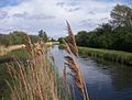
Wicken Lode
