
Camp Hill, Alabama facts for kids
Quick facts for kids
Camp Hill, Alabama
|
||
|---|---|---|

Camp Hill in 2021
|
||
|
||

Location of Camp Hill in Tallapoosa County, Alabama.
|
||
| Country | United States | |
| State | Alabama | |
| County | Tallapoosa | |
| Area | ||
| • Total | 9.09 sq mi (23.54 km2) | |
| • Land | 8.99 sq mi (23.28 km2) | |
| • Water | 0.10 sq mi (0.26 km2) | |
| Elevation | 712 ft (217 m) | |
| Population
(2020)
|
||
| • Total | 1,006 | |
| • Density | 111.90/sq mi (43.21/km2) | |
| Time zone | UTC-6 (Central (CST)) | |
| • Summer (DST) | UTC-5 (CDT) | |
| ZIP code |
36850
|
|
| Area code(s) | 256 | |
| FIPS code | 01-11680 | |
| GNIS feature ID | 0115465 | |

Camp Hill is a town in Tallapoosa County, Alabama, United States. It became an official town in 1895. In 2010, about 1,014 people lived there. Camp Hill is also home to Southern Preparatory Academy, which used to be called "Lyman Ward Military Academy."
Contents
History
In 1931, a group called the Alabama Sharecroppers' Union held a meeting in a church in Camp Hill. During this meeting, a conflict happened, and some people were hurt. Many union members were arrested. However, because of public and international pressure, all those arrested were later set free without a trial.
Geography
Camp Hill is located at 32°47′57″N 85°39′10″W / 32.79917°N 85.65278°W. This means it's in the southeastern part of the United States.
The United States Census Bureau says that the town covers about 9.1 square miles (23.5 square kilometers). Most of this area is land, with a very small part being water.
Population Information
| Historical population | |||
|---|---|---|---|
| Census | Pop. | %± | |
| 1890 | 366 | — | |
| 1900 | 686 | 87.4% | |
| 1910 | 896 | 30.6% | |
| 1920 | 952 | 6.3% | |
| 1930 | 1,131 | 18.8% | |
| 1940 | 1,147 | 1.4% | |
| 1950 | 1,296 | 13.0% | |
| 1960 | 1,270 | −2.0% | |
| 1970 | 1,554 | 22.4% | |
| 1980 | 1,628 | 4.8% | |
| 1990 | 1,415 | −13.1% | |
| 2000 | 1,273 | −10.0% | |
| 2010 | 1,014 | −20.3% | |
| 2020 | 1,006 | −0.8% | |
| U.S. Decennial Census 2013 Estimate |
|||
What the 2010 Census Showed
In 2010, Camp Hill had 1,014 residents living in 450 households. About 269 of these were families. The town had about 111 people per square mile.
Most of the people in Camp Hill were Black or African American (88.4%). About 10.2% were White. A small number of people were from other backgrounds.
About 22.1% of the people were under 18 years old. The average age in Camp Hill was 41.8 years.
What the 2020 Census Showed
The 2020 United States census counted 1,006 people living in Camp Hill. There were 384 households and 279 families.
Here's a look at the racial makeup of the town in 2020:
| Race | Number | Percentage |
|---|---|---|
| White (not Hispanic) | 105 | 10.44% |
| Black or African American (not Hispanic) | 875 | 86.98% |
| Native American | 1 | 0.1% |
| Asian | 3 | 0.3% |
| Other/Mixed | 16 | 1.59% |
| Hispanic or Latino | 6 | 0.6% |
Famous Person
- Bill Higdon: A former Major League Baseball player.
Town Pictures
-
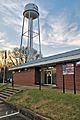
Camp Hill Town Hall
-
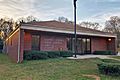
Camp Hill Post Office (ZIP code: 36850)
-
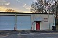
Camp Hill Volunteer Fire Department
-
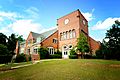
Camp Hill is home to Southern Preparatory Academy. It was formerly known as "Lyman Ward Military Academy". Tallapoosa Hall (pictured) was completed in 1930 with the help of Booker T. Washington and employees of Tuskegee University. It was added to the Alabama Register of Landmarks and Heritage on January 24, 2008.
-
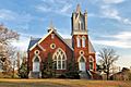
The First Universalist Church of Camp Hill was designed by Birmingham architect Daniel A. Helmich and built in 1907 using local materials. It was added to the Alabama Register of Landmarks and Heritage on March 13, 1996.
-
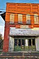
The Winter's Grocery Building in Camp Hill


Climate
Camp Hill has a climate with hot, humid summers and mild to cool winters. This type of weather is called a humid subtropical climate. It means the area gets a good amount of rain throughout the year, and the temperatures are generally warm.
| Climate data for Camp Hill, Alabama | |||||||||||||
|---|---|---|---|---|---|---|---|---|---|---|---|---|---|
| Month | Jan | Feb | Mar | Apr | May | Jun | Jul | Aug | Sep | Oct | Nov | Dec | Year |
| Mean daily maximum °C (°F) | 14 (57) |
16 (60) |
19 (67) |
24 (76) |
28 (83) |
32 (89) |
33 (91) |
32 (90) |
31 (87) |
25 (77) |
19 (67) |
14 (58) |
24 (75) |
| Mean daily minimum °C (°F) | 1 (34) |
2 (35) |
6 (42) |
9 (49) |
14 (57) |
18 (65) |
19 (67) |
19 (67) |
17 (62) |
10 (50) |
4 (40) |
2 (35) |
10 (50) |
| Average precipitation mm (inches) | 130 (5.1) |
130 (5.1) |
150 (6.1) |
120 (4.7) |
94 (3.7) |
99 (3.9) |
130 (5.3) |
110 (4.3) |
91 (3.6) |
69 (2.7) |
84 (3.3) |
130 (5.2) |
1,340 (52.9) |
| Source: Weatherbase | |||||||||||||
See also
 In Spanish: Camp Hill (Alabama) para niños
