
Camp Lake (Alaska) facts for kids
Quick facts for kids Camper's Lake |
|
|---|---|

Camper's Lake
Location in Alaska

Camper's Lake
Location in North America
|
|
| Location | Baranof Island, Sitka City and Borough, Alaska, US |
| Coordinates | 57°2′N 135°5′W / 57.033°N 135.083°W |
| Type | Tarn |
| Primary outflows | Camper's Lake Valley Stream |
| Basin countries | United States |
| Surface elevation | 1,600 ft (490 m) |
Camp Lake is a beautiful, small lake found on Baranof Island in Alaska. It gets its water from melting snow and rain. This clear lake is part of the Blue Lake watershed, which means its water eventually flows into Blue Lake. Camp Lake is a very popular spot for hikers, especially for those starting the famous Baranof Cross-Island Trail. People love to camp here on their first night because of the pretty open meadows around it and the incredibly clear water.
Where is Camp Lake Located?
Camp Lake is nestled between two mountains: Bear Mountain and Mount Bassie. It sits high up on a small cliff overlooking the Medvejie Lake valley. Even though it's near Medvejie Lake, its water actually drains into the Blue Lake system. The lake is located at 57°2′N 135°5′W / 57.033°N 135.083°W.
Hiking to Camp Lake
If you want to visit Camp Lake, you can start your hike from the Medvejie Hatchery. The trail to the lake is about 3.33 miles (5.4 kilometers) long. It's a challenging hike because the ground can be tough to walk on, and some parts have very thick plants. But the effort is worth it for the stunning views and clear waters of Camp Lake!
What's in a Name?
You might find it interesting that Camp Lake isn't officially named on maps from the United States Geological Survey (USGS). However, a hunter named Les Yaw wrote a book where he called it "Camper's Lake." This is how the lake got its common name among hikers and locals.
Images for kids
-
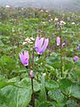
Camp Lake alpine meadow in early July, 2014
-
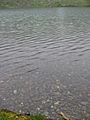
The West shore of Camp Lake


