Mount Bassie facts for kids
Quick facts for kids Mount Bassie |
|
|---|---|

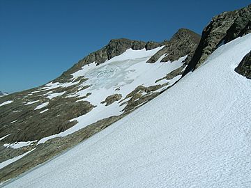
The western face of Mount Bassie.
|
|
| Highest point | |
| Elevation | 4,301 ft (1,311 m) |
| Prominence | 3,755 ft (1,145 m) |
| Geography | |
| Location | Baranof Island, Sitka City and Borough, Alaska |
| Topo map | USGS Sitka |
| Climbing | |
| First ascent | Unknown |
| Easiest route | Scramble |
Mount Bassie is a really big mountain located in Alaska, United States. You can find it right in the middle of Baranof Island, which is part of the City and Borough of Sitka.
About Mount Bassie
Mount Bassie is a huge, rocky mountain. It covers an area of almost five square miles! This mountain is surrounded by important water areas. These include the Blue Lake and Medvejie Lake watersheds. It is also near the Baranof River watershed.
Because of its size and location, Mount Bassie actually divides Baranof Island. From its top, you can see both Chatham Strait and the Pacific Ocean. This shows how tall and central it is on the island.
Where is Mount Bassie Located?
Mount Bassie is very close to Camp Lake. Most people who want to climb Mount Bassie start their journey from Camp Lake. The mountain stands pretty much by itself. It doesn't have many other tall peaks right next to it.
It only has two smaller ridges. These ridges extend from the south and north sides of the mountain. The rest of Mount Bassie slopes down very steeply. These steep slopes lead into the river valleys around it.
Climbing and Trails
Not many people reach the very top of Mount Bassie. It is a challenging climb. However, the western side of the mountain is often used. This part is a section of the famous Baranof Cross-Island Trail. This trail lets hikers travel across the island.
 | Jackie Robinson |
 | Jack Johnson |
 | Althea Gibson |
 | Arthur Ashe |
 | Muhammad Ali |

