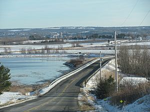
Canard River facts for kids
Quick facts for kids Canard River |
|
|---|---|
| Country | Canada |
| Province | Nova Scotia |
| Physical characteristics | |
| Main source | Camp Aldershot |
| River mouth | Minas Basin sea level |
| Length | 15 km (9.3 mi) |
The Canard River is a river located in Kings County, Nova Scotia, Canada. It flows into the Minas Basin, which is a part of the famous Bay of Fundy. This river is well-known for its rich, fertile banks. These areas are perfect for farming, especially because of the many dykes built there over time. The river runs between the communities of Canard and Starr's Point.
Contents
Exploring the Canard River's Geography
The Canard River starts from several small brooks. These brooks flow out of the sandy pine woods near Steam Mill Village. This area is now home to the Camp Aldershot military base.
The Canard River is not very long, only about 15 kilometers (9 miles). However, its lower parts are wide and deep. This is because of the huge tides from the Minas Basin. The Minas Basin has some of the highest tides in the world!
Long ago, the river was tidal for most of its length. This means the ocean's tides would flow far up the river. But people started building dykes in the 1600s. These dykes helped to hold back the tide. Now, the tide stops near the river's mouth. This is thanks to a large structure called the Wellington Dyke. The upper parts of the river are often named after the old dykes that crossed them, like Upper Dyke and Middle Dyke.
A Look at Canard River's History
Early Life: Mi'kmaq People and the River
The Mi'kmaq people were the first to live near the Canard River. They called it Apocheechumochwakade. This name means "home of the black duck." The Mi'kmaq also used the river's mouth for fishing. They especially fished for shad, a type of fish.
Acadian Settlers and Their Dykes
In the late 1600s, Acadians came to settle along the river. They named it Rivière-aux-Canards, which is French for "Duck River." The Acadians were skilled farmers. They began building small dykes to turn salty marshes into farmland. These first dykes were built in the upper parts of the river. This was near the areas now known as Steam Mill Village and Upper Dyke.
Later, a bigger dyke was built further down the river at Middle Dyke. Around 1750, an even larger dyke was constructed. It was over a mile long and was called the Grand Dyke. Today, the highway Route 358 crosses the river where this dyke once stood. By this time, the Acadian village on both sides of the river had about 750 people. They had many farms on the dyked land and several mills.
A church parish was started here in 1670. It was called Saint-Joseph-de-la-Rivière-aux-Canards. The best farms were located at the mouths of the Canard River and the Saint-Antoine River. The village of Rivière-aux-Canards was located west of Grand-Pré.
Changes and New Beginnings
The Acadian settlement faced a major change in 1755. This was during the Expulsion of the Acadians. On October 27, 1755, many Acadian families were moved from their homes. About 1,600 people from Grand-Pré and Rivière-aux-Canards left on fourteen ships. Another 1,300 people from Pisiguit and Cobequid joined them. These ships were very crowded. The villages of Grand-Pré, Pisiguit, and Rivière-aux-Canards were burned down.
With no one to take care of the dykes, a big storm hit in November 1759. The Grand Dyke was damaged, and the land flooded up to the Middle Dyke. This turned hundreds of acres of farmland back into tidal marshes.
New England Planters Arrive
In 1760, new settlers arrived. They were called the New England Planters. They took over the Acadian lands along the river. In December 1760, a government ship called the Montague was bringing supplies for the Planters. It was wrecked in the lower part of the river.
The Planter settlement on the south bank became known as Starr's Point. The settlement on the north bank became Canard. The Planters worked hard to repair the Middle Dyke. They rebuilt the Grand Dyke in 1782. In 1825, they built the Wellington Dyke near the mouth of the Canard River. This dyke protected over 3,000 acres of farmland from the strong tides of the Minas Basin.


