Canaveral Barge Canal facts for kids
Quick facts for kids Canaveral Barge Canal |
|
|---|---|

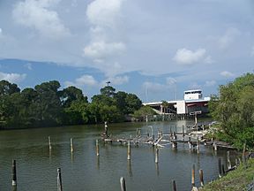
Barge canal, looking towards the Christa McAuliffe Bridge
|
|
| Specifications | |
| Locks | 1 |
| Maximum height above sea level | 3.3 ft (1.0 m) |
| Status | Open |
| Navigation authority | U.S. Army Corps of Engineers |
| History | |
| Date of first use | January 1, 1965 |
The Canaveral Barge Canal is a special waterway in Florida. It connects the Atlantic Ocean on the east with the Indian River Lagoon on the west. This canal cuts across the northern part of Merritt Island.
The canal is about 12 feet deep. It also links to other water systems like Sykes Creek and various boat marinas. This important canal connects Port Canaveral on the Atlantic coast to the Intracoastal Waterway. The Intracoastal Waterway is a long path for boats that runs along the middle of the Indian River Lagoon.
The Canaveral Barge Canal was built for a specific reason. It allowed large barges to carry crude oil to two power plants. These power plants are located south of Titusville, Florida. The canal officially opened on January 1, 1965.
Bridges Over the Canal
The Canaveral Barge Canal has important bridges that allow roads to cross over it. These bridges help people and vehicles move around Merritt Island.
Christa McAuliffe Bridge
The Christa McAuliffe Bridge is a special type of bridge called a bascule drawbridge. This means part of the bridge can lift up. It lifts to let tall boats pass underneath. This bridge carries SR 3, also known as Courtenay Parkway.
Barge Canal Bridge
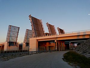
The Barge Canal Bridge is also a bascule drawbridge. It carries SR 401. This bridge is actually made up of three separate bridges next to each other. Each of these three bridges has a part that can lift up.
 | Laphonza Butler |
 | Daisy Bates |
 | Elizabeth Piper Ensley |


