Cannonville, Utah facts for kids
Quick facts for kids
Cannonville, Utah
|
|
|---|---|
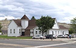
LDS church in Cannonville
|
|
| Nickname(s):
Shotgun (Before a new family moved in, then they called it Cannonville)
|
|
| Motto(s): | |
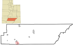
Location in Garfield County and state of Utah
|
|
| Country | United States |
| State | Utah |
| County | Garfield |
| Founded | 1874 |
| Incorporated | 1934 |
| Founded by | James L. Thompson |
| Named for | George Q. Cannon |
| Area | |
| • Total | 2.57 sq mi (6.65 km2) |
| • Land | 2.57 sq mi (6.65 km2) |
| • Water | 0.00 sq mi (0.00 km2) |
| Elevation | 5,886 ft (1,794 m) |
| Population
(2020)
|
|
| • Total | 186 |
| • Estimate
(2019)
|
173 |
| • Density | 67.42/sq mi (26.03/km2) |
| Time zone | UTC-7 (Mountain (MST)) |
| • Summer (DST) | UTC-6 (MDT) |
| ZIP code |
84718
|
| Area code(s) | 435 |
| FIPS code | 49-10330 |
| GNIS feature ID | 1426344 |
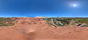
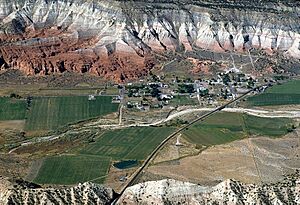
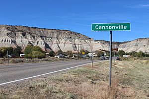
Cannonville is a small town in Garfield County, Utah, USA. It's located along a scenic road called Utah Scenic Byway 12. In 2020, about 186 people lived there.
Contents
History of Cannonville
Cannonville was started in 1874. A post office opened in 1879 and stayed open until 1966. The town was named after George Q. Cannon. He was an important leader in the Church of Jesus Christ of Latter-day Saints.
Exploring Cannonville's Location
Cannonville is in southern Garfield County. It sits in the valley of the Paria River. You can drive east about 3.5 miles (5.6 km) to Henrieville on State Route 12. Or, you can go north about 5 miles (8 km) to Tropic.
A famous place, Bryce Canyon National Park, is very close. It's only about 6 miles (9.7 km) away in a straight line. By road, it's about 16 miles (26 km) from Cannonville. The town covers an area of about 2.57 square miles (6.65 square kilometers). All of this area is land.
What's the Weather Like?
Cannonville has a desert climate. This means it has big changes in temperature between day and night. Winters are cold and dry, while summers are hot. Most of the rain falls during the late summer. This is known as the monsoon season. The area gets about nine inches of rain each year.
| Climate data for Cannonville, Utah | |||||||||||||
|---|---|---|---|---|---|---|---|---|---|---|---|---|---|
| Month | Jan | Feb | Mar | Apr | May | Jun | Jul | Aug | Sep | Oct | Nov | Dec | Year |
| Mean daily maximum °F (°C) | 32 (0) |
36 (2) |
43 (6) |
52 (11) |
63 (17) |
75 (24) |
81 (27) |
77 (25) |
72 (22) |
57 (14) |
46 (8) |
34 (1) |
56 (13) |
| Mean daily minimum °F (°C) | 14 (−10) |
16 (−9) |
25 (−4) |
32 (0) |
41 (5) |
50 (10) |
57 (14) |
55 (13) |
50 (10) |
37 (3) |
27 (−3) |
16 (−9) |
35 (2) |
| Average precipitation inches (mm) | 0.8 (21) |
1.0 (25) |
1.0 (26) |
0.7 (18) |
0.9 (22) |
0.6 (16) |
1.1 (27) |
1.7 (42) |
1.4 (36) |
1.1 (27) |
0.9 (23) |
0.9 (23) |
12.1 (306) |
| Average snowfall inches (cm) | 7.8 (19.9) |
7.2 (18.3) |
6.7 (17.1) |
1.9 (4.9) |
0.2 (0.5) |
0 (0) |
0 (0) |
0 (0) |
0 (0) |
0 (0) |
0.8 (2) |
2.8 (7) |
27.4 (69.7) |
| Average extreme snow depth inches (cm) | 6.7 (17) |
7.9 (20) |
5.9 (15) |
2.0 (5) |
0 (0) |
— | — | — | — | — | — | — | 7.9 (20) |
| Average precipitation days | 6 | 7 | 7 | 5 | 5 | 3 | 7 | 8 | 5 | 4 | 5 | 6 | 68 |
| Average relative humidity (%) | 71.5 | 69.3 | 62 | 53.5 | 45.9 | 36.2 | 43.9 | 50.1 | 48.9 | 57.1 | 63.9 | 70.1 | 56.0 |
| Mean daily daylight hours | 10.4 | 11.3 | 12.4 | 13.7 | 14.7 | 15.3 | 15 | 14 | 12.8 | 11.6 | 10.6 | 10.1 | 12.7 |
| Source: Weatherbase World Weather online(Temperatures-Snowfall 2009-2023) | |||||||||||||
Who Lives in Cannonville?
| Historical population | |||
|---|---|---|---|
| Census | Pop. | %± | |
| 1880 | 137 | — | |
| 1890 | 273 | 99.3% | |
| 1900 | 211 | −22.7% | |
| 1910 | 219 | 3.8% | |
| 1920 | 311 | 42.0% | |
| 1930 | 227 | −27.0% | |
| 1940 | 250 | 10.1% | |
| 1950 | 205 | −18.0% | |
| 1960 | 153 | −25.4% | |
| 1970 | 113 | −26.1% | |
| 1980 | 134 | 18.6% | |
| 1990 | 131 | −2.2% | |
| 2000 | 148 | 13.0% | |
| 2010 | 167 | 12.8% | |
| 2019 (est.) | 173 | 3.6% | |
| U.S. Decennial Census | |||
In 2000, there were 148 people living in Cannonville. These people lived in 50 different homes. Most of the people were White. About 4% of the population was of Hispanic or Latino background.
Many homes had children under 18 living there. The average household had almost three people. The average family had more than three people. The median age in the town was 38 years old. This means half the people were younger than 38, and half were older.
See also
 In Spanish: Cannonville (Utah) para niños
 | James B. Knighten |
 | Azellia White |
 | Willa Brown |


