
Cao Bằng province facts for kids
Quick facts for kids
Cao Bằng province
Tỉnh Cao Bằng
|
|
|---|---|
|
From top, left to right: Ban Gioc Falls, Bằng Giang Bridge, Kim Đồng Tomb, Paddy field in Cao Bằng, Ngườm Ngao Cave
|
|
| Nickname(s):
High Plateau
|
|

Location of Cao Bằng within Vietnam
|
|
| Country | |
| Region | Northeast |
| Capital | Cao Bằng |
| Subdivision | 1 city, 9 rural districts |
| Government | |
| • Type | Province |
| • Body | Cao Bằng Provincial People's Council |
| Area | |
| • Province | 6,700.39 km2 (2,587.04 sq mi) |
| Population
(2021)
|
|
| • Province | 535,086 |
| • Density | 79.85893/km2 (206.8337/sq mi) |
| • Urban | 136,010 |
| Ethnic groups | |
| • Tày | 40.84% |
| • Nùng | 29.81% |
| • Mông | 11.65% |
| • Dao | 10.36% |
| • Vietnamese | 5.12% |
| • Others | 2.22% |
| Time zone | UTC+07:00 (ICT) |
| Area codes | 206 |
| ISO 3166 code | VN-04 |


Cao Bằng is a province in the Northeast region of Vietnam. It shares borders with other Vietnamese provinces like Hà Giang and Lạng Sơn. It also has an international border with Guangxi province in China. The province covers about 6,700 square kilometers. As of 2019, around 530,000 people live there.
This area has a long and interesting history, going back to the Bronze Age. Cao Bằng is known for its historical sites and beautiful natural places. These include the Pác Bó cave, where Hồ Chí Minh started a revolutionary movement. You can also find the amazing Bản Giốc waterfall here, right on the border with China.
Contents
History of Cao Bằng
Cao Bằng's story began in the Bronze Age. This was when the Tày Tây Âu Kingdom was strong. The Tây Âu people were groups of tribes living in the mountains of northern Vietnam and southern China. Their capital was believed to be near today's Cao Bằng City.
Because Cao Bằng is close to China, its history has been quite eventful. The area changed hands many times over the centuries. In the 11th century, it became part of Đại Việt, which was an old name for Vietnam.
Later, in the 16th century, the Mạc family took control of the region. They even declared it an independent area and ruled for 75 years. You can still see the ruins of their palace near Cao Bằng City. When the French took over in 1884, they moved the capital to the Cao Bằng peninsula.
Cao Bằng is also famous for its role in Vietnam's fight for independence. In the 1920s, it became a key place for revolutionaries. The Communist Party of Vietnam used the province's rough mountains as a safe base. In 1941, Hồ Chí Minh, a very important leader, returned from China. He set up his headquarters at Pắc Bó cave in Cao Bằng. This was a crucial spot for the revolutionary movement from 1940 to 1945.
In 1979, during a brief war with China, Chinese troops entered Cao Bằng city. They caused a lot of damage, destroying many buildings. The historical Pác Bó caves were also affected. However, the city has been rebuilt since then.
Geography and Nature
Cao Bằng province is in northern Vietnam. It shares borders with several Vietnamese provinces and a long border with China. The main city in the province is also called Cao Bằng.
Most of Cao Bằng is mountainous, so there isn't much flat land for people to live on. The average temperature is about 22 degrees Celsius (72°F). In winter, some areas can get very cold, with freezing temperatures and even some snow.
The famous Bản Giốc Waterfall is a major natural wonder here. It sits right on the border with China. The province stretches about 80 kilometers (50 miles) from northwest to southeast and 170 kilometers (106 miles) from east to west. Over 90% of the province is covered by mountainous forests.
The city of Cao Bằng is located where the Bằng Giang and Hien rivers meet. It's about 270 kilometers (168 miles) from Hanoi. The city is about 300 meters (984 feet) above sea level, which gives it a pleasant climate all year round.
Climate in Cao Bằng
The weather in Cao Bằng is generally mild. Here's a quick look at the average temperatures and rainfall:
| Month | Jan | Feb | Mar | Apr | May | Jun | Jul | Aug | Sep | Oct | Nov | Dec | Year |
|---|---|---|---|---|---|---|---|---|---|---|---|---|---|
| Mean daily maximum °C (°F) | 18 (64) |
19 (66) |
23 (73) |
27 (81) |
31 (88) |
32 (90) |
32 (90) |
32 (90) |
31 (88) |
27 (81) |
24 (75) |
20 (68) |
26 (80) |
| Mean daily minimum °C (°F) | 10 (50) |
12 (54) |
16 (61) |
19 (66) |
23 (73) |
24 (75) |
24 (75) |
24 (75) |
22 (72) |
19 (66) |
15 (59) |
11 (52) |
18 (65) |
| Average rainfall mm (inches) | 22 (0.9) |
26 (1.0) |
39 (1.5) |
91 (3.6) |
174 (6.9) |
229 (9.0) |
224 (8.8) |
249 (9.8) |
150 (5.9) |
91 (3.6) |
44 (1.7) |
20 (0.8) |
1,359 (53.5) |
| Average rainy days | 10 | 10 | 12 | 14 | 15 | 17 | 18 | 19 | 14 | 12 | 9 | 8 | 158 |
| Mean monthly sunshine hours | 62 | 56 | 93 | 120 | 186 | 150 | 186 | 186 | 180 | 155 | 120 | 124 | 1,618 |
| Source: World Climate Guide | |||||||||||||
People and Cultures
Cao Bằng province is home to many different ethnic groups. The largest groups are the Tày, Nùng, Hmong, and Dao.
In 2019, the province had a population of about 530,000 people. This makes it one of the less crowded provinces in northern Vietnam. Most people live in rural areas. Each ethnic group has its own language, traditions, and unique culture.
Here are the main ethnic groups and their percentages:
- Tày (40.84%)
- Nùng (29.81%)
- Mông (11.65%)
- Dao (10.36%)
- Vietnamese (5.12%)
- Other groups make up the rest (2.22%)
Many different languages are spoken in Cao Bằng province, including various Hmong-Mien, Tai, Kra, and Tibeto-Burman languages.
How Cao Bằng is Organized
Cao Bằng is divided into 10 main areas. These include one city, which is Cao Bằng City, and nine rural districts. These districts are further divided into smaller communities.
Economy and Life
Cao Bằng is not as wealthy as some other provinces in Vietnam. Its economy mainly relies on agriculture (farming) and forestry (managing forests).
Even though schools and hospitals used to be in poor condition, they are slowly getting better. Transportation, which was a big challenge, has also improved a lot thanks to new roads. Most of the farms here are small, family-run operations.
Places to Visit
Cao Bằng has many interesting places to explore, both historical and natural.
- Pác Bó

Pác Bó is a very important historical site. It's located where the Bằng Giang and Hien rivers meet. In 1941, after being away for 30 years, Hồ Chí Minh returned to Vietnam and set up his headquarters in a cave near Pác Bó. From here, he trained revolutionary fighters and worked on plans for Vietnam's independence. He even started a revolutionary newspaper called 'Independent Vietnam'. A stream and a hill nearby were named "Lenin Stream" and "Karl Marx Mountain" to honor communist leaders. Today, you can visit the Pac Ba Vestiges Area Exhibition Centre to see artifacts from this time.
- Kỳ Sầm Temple
Kỳ Sầm Temple was built to honor Nùng Trí Cao. He was a Nùng leader who led a rebellion against the Vietnamese monarchy in the 11th century. The temple, though old, has been rebuilt and now has two buildings. It tells the story of Cao's bravery and his fight for his people.
- Coi Binh Church
Coi Binh Church was built by the French in 1906. It's one of three churches they built in the area. While many buildings around it were destroyed in 1979, the vicar's house still stands. Today, it's known for its famous honeybee farms.
- Mạc King's Temple
Mạc King's Temple is the 16th-century palace of the Mạc Dynasty. It sits on a hilltop overlooking the Dau Gen River. The Mạc family ruled this area for 65 years. Even now, you can see old cannons near the entrance of this small palace.
Natural Wonders
Cao Bằng is full of beautiful mountains, forests, rivers, and springs. The area around the Bản Doc Waterfall is a popular tourist spot.
- Bản Giốc waterfall


The Bản Giốc Waterfalls are about 80 kilometers (50 miles) north of Cao Bằng, right on the border between Vietnam and China. The water falls from a height of 30 meters (98 feet) and is 300 meters (984 feet) wide. When the sunlight hits the falling water, it often creates a beautiful rainbow. The area around the falls is also home to many green trees and fragrant flowers.
This waterfall is the fourth largest waterfall in the world that sits on a national border. Only Iguazu Falls, Victoria Falls, and Niagara Falls are larger. The waterfall is also known for a special type of fish called "tram huong." In the 1920s, the French used this area for hunting and fishing.
- Thang Hen Mountain lake
Thang Hen Mountain lake is a unique place with 36 small natural lakes. They are located on top of a hill about 1,000 meters (3,280 feet) high. These lakes formed in limestone rocks. What's special about them is that their water levels change, much like ocean tides. This happens because of water springs coming from deep underground. The water from these lakes eventually flows into the river that feeds the Bản Giốc waterfall.
Images for kids
-
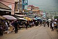
A market in Cao Bằng
-
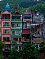
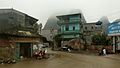
Houses in Cao Bằng
-
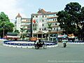
Bằng Giang Hotel
-
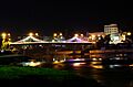
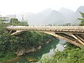
Bằng Giang Bridge
-
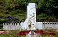
Kim Đồng Tomb
-
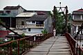
A suspension bridge in Cao Bằng
-
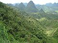
Limestone formations
-
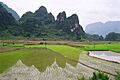
Paddy fields in Cao Bằng
-
Morning mist in Cao Bằng
-
A view of Quảng Uyên district
-
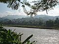
Bằng River at the border
-
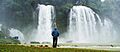
Bản Giốc Waterfall


See also
 In Spanish: Provincia de Cao Bằng para niños
