
Victoria Falls facts for kids
Quick facts for kids Victoria Falls |
|
|---|---|
| Mosi-oa Tunya Shungu Namutitima |
|
 |
|
| Lua error in Module:Location_map at line 530: Unable to find the specified location map definition: "Module:Location map/data/Africa Zambezi River" does not exist. | |
| Lua error in Module:Infobox_mapframe at line 185: attempt to index field 'wikibase' (a nil value). | |
| Coordinates | 17°55′28″S 25°51′24″E / 17.92444°S 25.85667°E |
| Type | Cataract waterfall |
| Total height | 108 m (355 ft) |
| Number of drops | 1 |
| Watercourse | Zambezi River |
| Average flow rate |
1,088 m3/s (38,400 cu ft/s) |
| Official name: Mosi-oa-Tunya / Victoria Falls | |
| Type: | Natural |
| Criteria: | vii, viii |
| Designated: | 1989 (13th session) |
| Reference #: | 509 |
| Region: | List of World Heritage Sites in Africa |
The Victoria Falls are amazing waterfalls located on the Zambezi River in Africa. They sit right on the border between two countries: Zambia and Zimbabwe. These falls are huge, about 1.7 kilometers (1 mile) wide and 128 meters (420 feet) high.
What makes them special is how the water drops into a very narrow crack in the earth. This means you can stand right across from them and see the entire waterfall face-on! The local name for the falls is Mosi-oa-Tunya, which means "The Smoke That Thunders." This name perfectly describes the loud roar and the massive cloud of spray that rises from the falling water.
Victoria Falls is part of two national parks: Mosi-oa-Tunya National Park in Zambia and Victoria Falls National Park in Zimbabwe. They are a major tourist spot in Southern Africa and are even a UNESCO World Heritage Site. They are much bigger than Niagara Falls in North America. While Iguazu Falls in South America has many smaller waterfalls, Victoria Falls is the largest single sheet of falling water in the world.
Contents
Discovering Victoria Falls

The first people to live near Victoria Falls were the Khoisan people, who were hunter-gatherers. Later, the Tokaleya people called the falls Shongwe. Different groups had their own names for the falls, like aManza Thunqayo by the Ndebele and Mosi-oa-Tunya by the Makololo.
The first European to see these incredible falls was David Livingstone. He was an explorer from Scotland. On November 17, 1855, during his journey across Africa, he reached the falls. He was so amazed that he named them after Queen Victoria, who was the Queen of the United Kingdom at that time. Livingstone wrote that no one could imagine how beautiful the view was. He said it looked like a scene that angels would gaze upon as they flew by.
In 1860, Livingstone came back to the falls with John Kirk to study them more closely. Other early European visitors included explorers like Serpa Pinto from Portugal and Emil Holub from the Czech Republic. Emil Holub even made the first detailed map of the falls in 1875. An artist named Thomas Baines painted some of the first pictures of the falls. For many years, not many Europeans visited the falls until a railway was built in 1905, making it easier to get there.
What Makes the Falls So Special?


The Victoria Falls are located about halfway along the Zambezi River. Before the falls, the river flows smoothly over flat basalt rock. There are many islands covered with trees in the river as it gets closer to the falls.
The falls are formed because the Zambezi River plunges into a narrow crack in the Earth's crust. This crack is about 120 meters (400 feet) wide. Many small islands at the top of the falls split the water, creating different sections of the waterfall. Over a very long time, the falls have slowly moved upstream, creating a series of zig-zagging gorges downstream.
The falls are very wide, about 1.7 kilometers (1 mile) across. The height of the water falling changes from 80 meters (262 feet) on one side to 108 meters (354 feet) in the middle. This means Victoria Falls is about twice as tall as Niagara Falls and more than twice as wide as Niagara's main section.
The powerful falling water creates a huge amount of spray and mist. This mist can rise over 400 meters (1,300 feet) high and can be seen from up to 50 kilometers (30 miles) away! When there's a full moon, you can even see a "moonbow" in the spray, which is like a rainbow but made by moonlight.
Water Flow and Volume
During the wet season (typically October to April), an incredible amount of water flows over the falls. More than 500 million liters (19 million cubic feet) of water fall every minute! The spray from this is so strong it rises hundreds of meters into the air. In 1958, the Zambezi River had a record flood, and over 770 million liters (27 million cubic feet) of water fell per minute.
To give you an idea, Niagara Falls has about 6 million cubic feet (about 170,000 cubic meters) of water per minute during its peak flow. This shows just how massive Victoria Falls is!
The falls are divided into four main parts by islands at the edge of the cliff. Near the right bank is a sloping waterfall called the Leaping Water. Beyond a 300-meter-wide island called Boaruka Island is the main fall, which is about 460 meters (1,500 feet) wide. Livingstone Island separates the main fall from another wide channel, and on the left side of the river is the Eastern Cataract.
Below the Falls: The Boiling Pot

The water from the falls pours into a narrow channel, about 30 meters (100 feet) wide. All the river's water flows through this channel for 120 meters (390 feet) before it enters a series of zig-zagging gorges. These gorges stretch for about 80 kilometers (50 miles) through the basalt plateau.
At the end of the first gorge, the river has carved out a deep pool called the Boiling Pot. This pool is about 150 meters (500 feet) across. When the water level is low, its surface is smooth. But when the water is high, you can see huge, slow swirls and powerful "boilings" on the surface. After the river leaves the Boiling Pot, it turns sharply and enters the next zig-zagging gorge. The walls of these gorges are over 120 meters (390 feet) high.

During the wet season (usually October to April), the river can release as much as 9,100 cubic meters (320,000 cubic feet) of water per second. At this time, the water flows over the main falls in one unbroken sheet. However, during the dry season, the falls can become much smaller, with only a few narrow cascades. The spray and mist almost disappear, and the water flow can drop to as little as 350 cubic meters (12,500 cubic feet) per second. During this time, you can often look down into the deep gorge, which is usually hidden by the spray. The river's level in the gorge can change by up to 20 meters (65 feet) between the highest flow in April and the end of the dry season in October.
The Railway Bridge
Just below the Boiling Pot, there's a large bridge that crosses the gorge. This bridge was finished in April 1905. It was originally planned as part of Cecil Rhodes' idea for a railway that would go all the way from Cape Town in South Africa to Cairo in Egypt.
The bridge is 250 meters (820 feet) long, and its main arch spans 150 meters (490 feet). The top of the bridge is 125 meters (410 feet) above the river's low-water level. Today, trains still use this bridge. They connect the towns of Victoria Falls and Livingstone, Zambia with Bulawayo, Zimbabwe. Another train line goes from Livingstone to Lusaka.
Images for kids
-
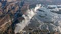
Aerial View
-
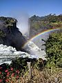
First Gorge, from Zambian side
-
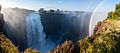
Victoria Falls from the Zimbabwe side
-
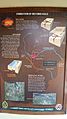
Victoria Falls National Park marker
-
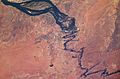
Satellite image showing the broad Zambezi falling into the narrow cleft and subsequent series of zigzagging gorges (top of picture is north).
-
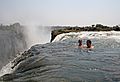
The naturally formed "Devil's Pool", where tourists swim despite a risk of plunging over the edge
-
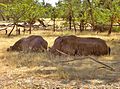
Two white rhinos at Mosi-oa-Tunya national park in May 2005. They are not indigenous, but were imported from South Africa.


See also
 In Spanish: Cataratas Victoria para niños
