Cape Carnot facts for kids
Quick facts for kids Cape CarnotSouth Australia |
|
|---|---|

|
|
| Elevation | 89 m (292 ft) |
| Location | 30 km (19 mi) south west of Port Lincoln |
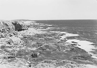
Cape Carnot is a special piece of land that sticks out into the ocean in South Australia. It's on the western side of the bottom tip of the Eyre Peninsula. This cape is about 30 kilometers (19 miles) southwest of the city of Port Lincoln.
The Eyre Peninsula actually has two tips close together. The other tip, called Cape Wiles, is about 3 nautical miles (5.6 km) to the east.
Discovery and Naming
Cape Carnot was first seen by a famous explorer named Matthew Flinders in February 1802. He explored the coast but didn't give this particular spot a name.
Later, in April 1802, another group of explorers from France, led by Nicolas Baudin, visited the area. They gave the cape the name "Cap Carnot."
It wasn't until 1913 that the government of South Australia officially gave the cape the name "Cape Carnot." This name honors Lazare Carnot. He was a very important French mathematician, general, and statesman. He played a big part in the French Revolution and the time of Napoleon.
Important Location
Cape Carnot is considered a very important point on the Australian coast. The Australian Hydrographic Service, which maps the seas, says that Cape Carnot is the eastern end of the huge Great Australian Bight. The Great Australian Bight is a very large bay or curve in the southern coastline of Australia.
Protecting Marine Life
Since 2012, the waters right next to Cape Carnot are part of a special protected area. This area is called a habitat protection zone within the Thorny Passage Marine Park. This means the marine park helps to protect the homes and living spaces of many ocean creatures in this area. It's important to keep these places safe for fish, plants, and other sea life.
 | Lonnie Johnson |
 | Granville Woods |
 | Lewis Howard Latimer |
 | James West |


