Cape Charles, Virginia facts for kids
Quick facts for kids
Cape Charles, Virginia
|
|||
|---|---|---|---|

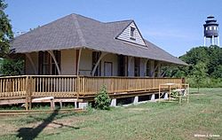
Bloxom Depot and the town water tower
|
|||
|
|||

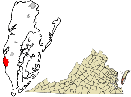
Location in Northampton County and the Commonwealth of Virginia
|
|||
| Country | United States | ||
| State | Commonwealth of Virginia | ||
| County | Northampton | ||
| Established as "Municipal Corporation of Cape Charles" | 1884 | ||
| Area | |||
| • Total | 3.62 sq mi (9.36 km2) | ||
| • Land | 3.55 sq mi (9.20 km2) | ||
| • Water | 0.06 sq mi (0.16 km2) | ||
| Elevation | 3 ft (0.9 m) | ||
| Population
(2020)
|
|||
| • Total | 1,178 | ||
| • Estimate
(2019)
|
1,019 | ||
| • Density | 286.80/sq mi (110.73/km2) | ||
| Time zone | UTC−5 (Eastern Standard Time (EST)) | ||
| • Summer (DST) | UTC−4 (EDT) | ||
| ZIP Code (U.S. Postal Service) |
23310
|
||
| Area codes | 757, 948 | ||
| FIPS code | 51-12808 | ||
| GNIS feature ID | 1492707 | ||
Cape Charles is a small town in Northampton County, Virginia, United States. It is located on the Eastern Shore of Virginia, close to the mouth of the Chesapeake Bay. In 2020, about 1,178 people lived there.
Contents
History of Cape Charles
Cape Charles was started in 1884. It was planned by a railroad company. The company wanted a new town and a port for their trains and ships. This town was built near the Chesapeake Bay, which was a great spot for trade.
How the Town Was Founded
In 1883, a man named William Lawrence Scott bought a lot of land. He was the head of the New York, Philadelphia and Norfolk Railroad Company. He set aside land for the railroad and for the new town. The town was officially called the "Municipal Corporation of Cape Charles."
The town was named after the nearby Cape Charles headland. Scott sold some land to the railroad company. This land became the southern end of their railway line. Construction of the railroad began in the same year.
Building the Harbor and Town Layout
The railroad company built a large harbor in Cape Charles. This harbor was used for steamships and freighters. These ships traveled between Cape Charles and Norfolk. The town was carefully planned out. It had 644 lots spread over 136 acres.
The main streets running east to west were named after important Virginia leaders. The streets running north to south were named after fruits. This original design is still clear today. It was inspired by the city of Erie, Pennsylvania, where Scott used to be mayor.
Harbor Development and Trade
In 1890, the United States Army Corps of Engineers helped improve the harbor. They dug out the harbor basin and its entrance. They also built stone walls to protect the harbor. By 1912, the Cape Charles harbor was very busy. It handled about 2.5 million tons of goods each year.
Ferry and Railroad Connections
For many years, Cape Charles was a key spot for ferry services. The Little Creek-Cape Charles Ferry carried people and cars. It crossed the Chesapeake Bay to cities like Norfolk and Virginia Beach. The last ferry left Cape Charles in 1963.
The town also served as a terminal for railway barges. These barges carried train cars across the bay. The Eastern Shore Railroad (later Bay Coast Railroad) used this service. However, the Bay Coast Railroad stopped running in 2018. There is also a cement factory nearby.
Historic Places in Town
Two important places in Cape Charles are listed on the National Register of Historic Places. These are the Cape Charles Historic District and Stratton Manor. This means they are recognized for their historical importance.
Population of Cape Charles
| Historical population | |||
|---|---|---|---|
| Census | Pop. | %± | |
| 1900 | 1,040 | — | |
| 1910 | 1,948 | 87.3% | |
| 1920 | 2,517 | 29.2% | |
| 1930 | 2,527 | 0.4% | |
| 1940 | 2,299 | −9.0% | |
| 1950 | 2,427 | 5.6% | |
| 1960 | 2,041 | −15.9% | |
| 1970 | 1,689 | −17.2% | |
| 1980 | 1,512 | −10.5% | |
| 1990 | 1,398 | −7.5% | |
| 2000 | 1,134 | −18.9% | |
| 2010 | 1,009 | −11.0% | |
| 2020 | 1,178 | 16.7% | |
| 2022 (est.) | 1,183 | 17.2% | |
| U.S. Decennial Census | |||
As of the 2000 census, Cape Charles had 1,134 people. There were 536 households in the town. About 21% of these households had children under 18. The average household had about 2 people.
The population's age spread showed that 22% were under 18. About 24% were 65 or older. The average age in town was 44 years.
Geography and Climate
Cape Charles is located at 37°16′03″N 76°00′51″W / 37.267522°N 76.014125°W.
Location and Landscape
Cape Charles sits on a peninsula, so it has water on three sides. The town is right on the Chesapeake Bay. King's Creek is to the north, and Old Plantation Creek is to the south. The land in town is mostly flat and low. The highest point is only about 15 feet above sea level. Most of the town is between 5 and 10 feet high.
The town covers about 4.4 square miles. Most of this area, about 3.7 square miles, is land. The rest, about 0.7 square miles, is water.
Chesapeake Bay Impact Crater
About 35 million years ago, a comet or asteroid hit the Atlantic Ocean shelf. This created a huge crater. This crater is about 53 miles wide. It is centered near the town of Cape Charles. This event shaped the land in the area.
Weather in Cape Charles
Cape Charles has a humid subtropical climate. This means it has hot, humid summers. Winters are chilly but not extremely cold. Temperatures often go above 90°F in summer. In winter, they usually drop below freezing.
The town gets about 45 inches of rain each year. Cape Charles also gets a lot of sunshine. It has about 2300 hours of sunshine every year. This is more than the average for the USA.
| Climate data for Cape Charles, 1991–2020 normals, extremes 2004–present | |||||||||||||
|---|---|---|---|---|---|---|---|---|---|---|---|---|---|
| Month | Jan | Feb | Mar | Apr | May | Jun | Jul | Aug | Sep | Oct | Nov | Dec | Year |
| Record high °F (°C) | 72 (22) |
76 (24) |
83 (28) |
87 (31) |
92 (33) |
98 (37) |
102 (39) |
98 (37) |
93 (34) |
92 (33) |
80 (27) |
78 (26) |
102 (39) |
| Mean maximum °F (°C) | 66.6 (19.2) |
68.4 (20.2) |
75.5 (24.2) |
82.2 (27.9) |
86.4 (30.2) |
92.5 (33.6) |
94.2 (34.6) |
91.3 (32.9) |
88.4 (31.3) |
82.6 (28.1) |
73.9 (23.3) |
70.4 (21.3) |
95.6 (35.3) |
| Mean daily maximum °F (°C) | 46.6 (8.1) |
48.7 (9.3) |
54.8 (12.7) |
64.7 (18.2) |
72.4 (22.4) |
80.7 (27.1) |
85.3 (29.6) |
83.4 (28.6) |
77.9 (25.5) |
68.6 (20.3) |
58.6 (14.8) |
50.9 (10.5) |
66.1 (18.9) |
| Daily mean °F (°C) | 39.4 (4.1) |
41.0 (5.0) |
46.8 (8.2) |
56.1 (13.4) |
64.9 (18.3) |
73.5 (23.1) |
78.3 (25.7) |
76.2 (24.6) |
70.9 (21.6) |
60.8 (16.0) |
50.9 (10.5) |
43.3 (6.3) |
58.5 (14.7) |
| Mean daily minimum °F (°C) | 32.1 (0.1) |
33.3 (0.7) |
38.8 (3.8) |
47.5 (8.6) |
57.5 (14.2) |
66.4 (19.1) |
71.3 (21.8) |
69.1 (20.6) |
63.9 (17.7) |
53.0 (11.7) |
43.2 (6.2) |
35.6 (2.0) |
51.0 (10.6) |
| Mean minimum °F (°C) | 16.9 (−8.4) |
18.7 (−7.4) |
25.2 (−3.8) |
34.1 (1.2) |
43.8 (6.6) |
54.2 (12.3) |
61.3 (16.3) |
59.8 (15.4) |
52.7 (11.5) |
38.8 (3.8) |
28.4 (−2.0) |
23.3 (−4.8) |
14.8 (−9.6) |
| Record low °F (°C) | 5 (−15) |
6 (−14) |
18 (−8) |
28 (−2) |
35 (2) |
46 (8) |
55 (13) |
54 (12) |
46 (8) |
32 (0) |
24 (−4) |
15 (−9) |
5 (−15) |
| Average precipitation inches (mm) | 3.37 (86) |
2.91 (74) |
3.52 (89) |
3.37 (86) |
3.47 (88) |
3.82 (97) |
4.67 (119) |
4.14 (105) |
4.21 (107) |
4.35 (110) |
3.08 (78) |
3.54 (90) |
44.45 (1,129) |
| Average precipitation days (≥ 0.01 in) | 10.1 | 10.3 | 10.0 | 11.2 | 11.8 | 11.9 | 10.8 | 12.1 | 8.7 | 9.2 | 8.9 | 10.1 | 125.1 |
| Source: NOAA | |||||||||||||
Transportation
Major Highways
 SR 184
Public Transportation
STAR Transit offers public bus services in Cape Charles.
Fun Things to Do
Cape Charles has a lot to offer for fun and relaxation.
Public Beach and Pier
The town has one of the only public beaches on the bayside of Virginia's Eastern Shore. This beach stretches for half a mile along Bay Avenue. There's a paved walkway next to it. People love to swim, sunbathe, and play here.
You can get to the beach from two wooden walkways. There's also the town's Fun Pier. This pier goes out into the water and has benches. It's a great spot for sightseeing. The beach sometimes needs new sand to keep it wide and sandy.
Boat Ramps and Nature Preserve
Cape Charles also has a public boat ramp. This is one of only three such ramps on the bay side of Northampton County.
Near the town is the 29-acre Cape Charles Natural Area Preserve. It has a long boardwalk that goes through different natural areas. You can see a Maritime Loblolly Pine Forest. The boardwalk ends at a low cliff overlooking the Chesapeake Bay. This preserve is home to special insects and is important for birds. Many songbirds and raptors stop here during their fall migration. They rest and eat before flying across the Chesapeake Bay.
Local Industries
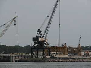
The Cape Charles Harbor is important for local businesses and visitors. It was first built to load and unload railroad cars onto barges. Today, it still has large docks for industrial use.
The main industrial areas are around the harbor. These include the old Eastern Shore Railroad area and Bayshore Concrete. There's also a commercial dock and a Sustainable Technology Park. These places help the town's economy.
Famous People from Cape Charles
- Roxie Joynes Campanella (1916–2004), a nurse and helper of others.
- Johnny Sample (1936–2005), a football player who won three NFL championships.
- Conny Van Dyke (1945–2023), a singer and actress.
See also
 In Spanish: Cape Charles para niños


