
Cape Chignecto Provincial Park facts for kids
Quick facts for kids Cape Chignecto Provincial Park |
|
|---|---|
|
IUCN Category II (National Park)
|
|

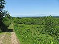
The cliffs of Cape Chignecto viewed from Red Rocks trailhead and visitor centre
|
|
| Location | Nova Scotia, Canada |
| Nearest city | Amherst, Nova Scotia, Truro, Nova Scotia |
| Area | 42 km2 (16 sq mi), 4,200 ha (10,000 acres) |
| Established | 1989 |
| Governing body | Nova Scotia Department of Natural Resources |
Cape Chignecto Provincial Park is a huge Canadian provincial park found in Nova Scotia. It's a wild and natural place, named after Cape Chignecto, a big piece of land that sticks out into the water. This cape separates the Bay of Fundy from Chignecto Bay to the north and the Minas Channel (which goes to the Minas Basin) to the east. The park first opened in 1998 and is the biggest provincial park in Nova Scotia. It's also an important part of the UNESCO Cliffs of Fundy Global Geopark, which is a special area recognized for its amazing geology.
Contents
Amazing Landscapes and Nature
This park is famous for its incredible coastline. It has long trails for backpacking and shorter paths for day hikes. The tallest cliffs in Mainland Nova Scotia are found here, reaching up to 200 metres (about 600 feet) along the southern coast.
Unique Coastal Features
Cape Chignecto Provincial Park covers 42 square kilometres (16 square miles). It has 30 kilometres (19 miles) of wild coastline. You can see cool geological features like raised beaches, caves, and tall sea stacks. These amazing rock formations were created when continents crashed together along the Cobequid fault. The park's stunning coastal views make it a popular spot for hikers and kayakers.
Forests and Wildlife
The park also has "fog forests." These grow because warm summer air mixes with the cold Bay of Fundy tides. This creates a lot of fog, making the conditions similar to a rain forest. These misty forests are home to large red spruce trees. Many unique and endangered lichens also thrive here.
The high southern cliffs support special plants. These include types of vetch and primrose that usually grow in Alpine (mountain) areas. They are very rare in Nova Scotia. Cape Chignecto also helps protect Nova Scotia's endangered mainland moose herd.
Powerful Tides
The tides along the park's coast are incredibly strong. They can rise and fall by 12 metres (about 39 feet)! This creates strong rip currents and can cause areas to flood very quickly. Hikers sometimes get trapped by the rising water against the cliffs. For example, in 2014, a couple and their dog had to be rescued by helicopter from CFB Greenwood after getting stuck at Eatonville.
Park Facilities and Trails
The park has more than 50 kilometres (31 miles) of trails. Some are for day trips, while others are for overnight backpacking adventures.
Visitor Services
You'll find an interpretation centre, picnic area, washrooms, and a gift shop at the Red Rocks trailhead. This is near the community of Advocate Harbour.
Overnight Stays
If you want to stay longer, the park offers 51 backcountry campsites. There are also 28 walk-in sites. You can even rent cabins and bunkhouses along the trail system.
Other Features
A fire tower is located at the highest point of the park in New Yarmouth. It has been closed since 2012. In 2008-2009, a new interpretation centre was built at Eatonville. This centre runs "off-grid," meaning it generates its own power.
The Cape Chignecto Trails are part of a bigger project. This project is creating a 400 km (250 mi) hiking trail system called "Cape to Cape." It will connect Cape Chignecto with Cape George in Antigonish County.
The park is usually open from mid-June to mid-October. You can reach it from Route 209. It's also a key stop on the Fundy Shore Ecotour.
History of the Park
The Nova Scotia government bought the land for the park in 1989. It became part of the Crown land reserve, managed by the Department of Natural Resources. In the mid-1990s, this land was set aside to become a provincial park. Cape Chignecto Provincial Park officially opened to the public in 1998. This happened after several years of planning and building trails and campsites. It is the largest provincial park in Nova Scotia.
Park Management
Even though it's Nova Scotia's biggest provincial park, a local group called the Cumberland Regional Economic Development Association helped create and run it until 2012. The park was managed by a small team of seasonal staff. However, in 2012, the Department of Natural Resources took over. They made the park's fees the same as other provincial parks.
Geopark Status
In 2020, the park became part of the UNESCO "Cliffs of Fundy Global Geopark." The Three Sisters Day Use trails at Eatonville mark the start of this Geopark. It stretches all around Cape Chignecto and down the coast to Debert.
Images for kids
-
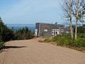
Eatonville Interpretation Centre
-
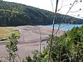
The park as viewed from atop the Eatonville Interpretation Centre
-
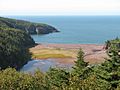
Eatonville Harbour saltmarsh and site of former mill and shipyard
-
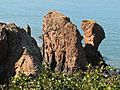
The "Three Sisters" sea stacks at Eatonville
-
The abandoned upland farm fields of New Yarmouh


