
Cape Northumberland (South Australia) facts for kids
Quick facts for kids Cape NorthumberlandPort MacDonnell, South Australia |
|
|---|---|

Cape Northumberland, from the west
|
|

Cape Northumberland
Location in South Australia
|
|
| Elevation | 30 m (98 ft) |
| Location |
|
| Footnotes | Locations |
Cape Northumberland is a special place in the southeast of South Australia. It's a headland, which means it's a piece of land that sticks out into the sea. This cape is the most southern point of South Australia.
You can find Cape Northumberland about 3 kilometres from the town of Port MacDonnell. It's also about 28 kilometres south of Mount Gambier. If you're coming from Adelaide, the state's capital, it's about 393 kilometres to the southeast.
Contents
Exploring Cape Northumberland
Cape Northumberland is a rugged and cliffy area. It stands about 30 metres high, which is like a 10-story building. Behind it, there's a hill that rises even higher, to about 41 metres. This makes it a dramatic spot where the land meets the ocean.
Where is it Located?
This cape is found on the very southeast coast of South Australia. It marks the western edge of a larger area called Discovery Bay. A smaller bay nearby, called MacDonnell Bay, is also part of this coastal region.
The Story of Cape Northumberland
Cape Northumberland has an interesting history, especially how it got its name and its connection to lighthouses.
How it Got its Name
The cape was named by a Royal Navy officer named James Grant. He was exploring and mapping the southern coast of Australia in the early 1800s. On December 3, 1800, he officially named this headland. He chose the name to honor Hugh Percy, who was the Duke of Northumberland at the time.
The Lighthouses of the Cape
Near Cape Northumberland, you'll find the site of a very old lighthouse. The first Cape Northumberland Lighthouse was built in 1887. Lighthouses are important because they guide ships safely past dangerous coastlines. Today, a newer lighthouse stands about 700 metres north of the original site, continuing to help ships navigate the waters.
Images for kids
-
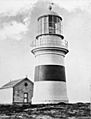
The first Cape Northumberland Lighthouse
-
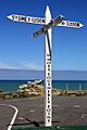
The sign at Cape Northumberland, marking South Australia's southernmost point
-
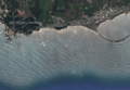
A satellite image of Cape Northumberland (left) showing its relationship to the coastline to its immediate east including the James Corcoran Breakwater


