Capels, West Virginia facts for kids
Quick facts for kids
Capels
|
|
|---|---|

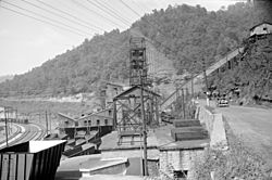
Coal tipple in Capels, 1938. Photo by Marion Post Wolcott.
|
|
| Country | United States |
| State | West Virginia |
| County | McDowell |
| Elevation | 1,309 ft (399 m) |
| Time zone | UTC-5 (Eastern (EST)) |
| • Summer (DST) | UTC-4 (EDT) |
| ZIP codes |
24820
|
| GNIS feature ID | 1554065 |
Capels is a small, unincorporated community located in McDowell County, West Virginia, United States. It sits right by the Tug Fork River. An "unincorporated community" means it's a place where people live, but it doesn't have its own local government like a city or town. Instead, it's governed by the county.
Contents
About Capels, West Virginia
Capels is found in the mountainous region of West Virginia. This area is known for its beautiful natural scenery and its history tied to the coal industry. The community is quite small, and its exact population isn't usually counted separately in official government surveys.
Where is Capels Located?
Capels is in the southern part of West Virginia. It's part of McDowell County, which is one of the southernmost counties in the state. The community is nestled along the Tug Fork River, which forms part of the border between West Virginia and Kentucky. Its elevation is about 1,309 feet above sea level.
How Did Capels Get Its Name?
The name Capels most likely came from a local family called Capel. It was common for communities in the past to be named after important families or landowners in the area.
Capels as a Coal Town
Like many communities in McDowell County, Capels has a history connected to coal mining. The picture in the infobox shows a "coal tipple" in Capels from 1938. A coal tipple was a structure used to load coal from mines into railroad cars or trucks. This shows that coal mining was an important activity in Capels during that time. Many people in these communities worked in the mines or in jobs related to the coal industry.
See also
 In Spanish: Capels (Virginia Occidental) para niños


