Capitol Park (Augusta, Maine) facts for kids
|
Capitol Park
|
|
|
U.S. Historic district
Contributing property |
|
 |
|
| Location | Roughly bounded by Capitol St., Kennebec River, Union St., and State St., Augusta, Maine |
|---|---|
| Area | 20 acres (8.1 ha) |
| Built | 1827 |
| Part of | Capitol Complex Historic District (ID01001417) |
| NRHP reference No. | 89000252 |
Quick facts for kids Significant dates |
|
| Added to NRHP | April 7, 1989 |
| Designated CP | December 31, 2001 |
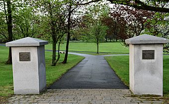
Capitol Park is a special public park in Augusta, Maine. It's part of Maine's state capitol area. The park sits on the west side of Augusta. It is located between the Maine State House and the Kennebec River. This land was first set aside in 1827.
During the American Civil War, the park was used as a training area. Soldiers would gather and camp there. Later, it was even used for farming for a short time. In the 1920s, famous landscape designers called the Olmsted Brothers created a formal plan for the park. Capitol Park was added to the National Register of Historic Places in 1989. This means it's an important historical site.
Contents
Discovering Capitol Park's History
Capitol Park is on the western bank of the Kennebec River. A former railroad path separates it from the river. The park is about 20 acres (8.1 ha) in size. It has a rough rectangular shape. Capitol, State, and Union Streets form its boundaries. The ground gently slopes up from the river to State Street. State Street separates the park from the Maine State House grounds.
How Capitol Park Began
The people of Augusta gave this land to the state in 1827. This gift included the park and the state house grounds. State Street was built to provide easy access. The state planted a line of trees along State Street. They also created a wide path from the state house to the river.
Charles Bulfinch, a famous architect, designed the state house grounds. He also planned how the park would look. His design included terraces, which are like steps, going down to the river. In 1842, a granite monument was placed in the park. It honored Governor Enoch Lincoln. By the 1850s, more trees were planted. Paths ran along these rows of trees. These paths were the main way to move through the park.
Changes During the Civil War
Sadly, all this beautiful landscaping was lost. The park became a staging ground for Maine's troops. This means soldiers gathered there before going off to fight in the American Civil War.
After the war, the park was plowed. It was briefly used for farming. But by 1878, it was a park again. It had paths similar to its earlier design.
Modern Park Design
In the 1920s, the state hired the Olmsted Brothers. They were well-known landscape architects. They created a big plan for all the state's properties. This included Capitol Park, the state house grounds, and the nearby governor's mansion. A landscape architect from Portland, Maine, named Carl Rust Parker, helped make these designs happen in the park.
 | Isaac Myers |
 | D. Hamilton Jackson |
 | A. Philip Randolph |


