Caracaraí facts for kids
Quick facts for kids
Caracaraí
|
|||
|---|---|---|---|
|
Municipality
|
|||
| The Municipality of Caracaraí | |||

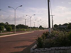
An avenue in Caracaraí
|
|||
|
|||

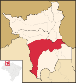
Location of Caracaraí in the State of Roraima
|
|||
| Country | |||
| Region | North | ||
| State | |||
| Founded | 1955 | ||
| Area | |||
| • Total | 47,411 km2 (18,305 sq mi) | ||
| Elevation | 52 m (171 ft) | ||
| Population
(2020)
|
|||
| • Total | 22,283 | ||
| • Density | 0.469996/km2 (1.21729/sq mi) | ||
| Time zone | UTC−4 (AMT) | ||
| HDI (2000) | 0.702 – medium | ||
| Website | www.caracarai.rr.gov.br | ||
Caracaraí (Portuguese pronunciation: [kaɾɐkaɾaˈi]) is a municipality (a type of city and region) located in the state of Roraima in Brazil. It's home to 22,283 people and covers a huge area of 47,411 square kilometers. This makes it the largest city area in Roraima state. You can find Caracaraí right on the Branco River.
Discovering Caracaraí
Caracaraí was started by cattle ranchers from a place called Moura. It was first known as Cidade Porto, which means 'Port City'. For a while, it was even the capital of the Rio Branco Territory, which later became Roraima.
The name Caracaraí means "little hawk". This type of bird is very common in the area. The municipality's land stretches across Roraima, bordering both the Brazilian state of Amazonas and the country of Guyana. Part of its border with Guyana is also claimed by Venezuela.
Location and Growth
Caracaraí is located near where two important highways meet: BR-174 and BR-210. It became an independent municipality in 1955. This means it gained its own local government.
Between 1960 and 1982, two other areas, Santa Maria do Boiaçu and São José de Anauá, were part of Caracaraí. Later, Santa Maria do Boiaçu became part of the nearby municipality of Rorainópolis.
Nature and Economy
The municipality is home to two special nature areas: the Caracaraí Ecological Station and the Niquiá Ecological Station. These places help protect local plants and animals.
In the past, Caracaraí's economy was mostly about cattle ranching. Cattle were often sent by boat to Manaus. Because it's on the Branco River and south of some waterfalls, Caracaraí became an important supply center for the whole region. Today, it is also the biggest producer of fish in the state of Roraima.
Climate in Caracaraí
Caracaraí has a tropical climate. This means it's generally warm all year round. The area experiences both wet and dry seasons, typical of regions near the equator.
| Climate data for Caracaraí (1981–2010) | |||||||||||||
|---|---|---|---|---|---|---|---|---|---|---|---|---|---|
| Month | Jan | Feb | Mar | Apr | May | Jun | Jul | Aug | Sep | Oct | Nov | Dec | Year |
| Mean daily maximum °C (°F) | 32.6 (90.7) |
33.0 (91.4) |
33.3 (91.9) |
32.7 (90.9) |
31.0 (87.8) |
30.9 (87.6) |
31.1 (88.0) |
32.3 (90.1) |
33.4 (92.1) |
34.2 (93.6) |
33.8 (92.8) |
32.8 (91.0) |
32.6 (90.7) |
| Daily mean °C (°F) | 27.0 (80.6) |
27.3 (81.1) |
27.6 (81.7) |
27.2 (81.0) |
26.2 (79.2) |
26.0 (78.8) |
25.8 (78.4) |
26.5 (79.7) |
27.4 (81.3) |
28.0 (82.4) |
27.8 (82.0) |
27.1 (80.8) |
27.0 (80.6) |
| Mean daily minimum °C (°F) | 21.4 (70.5) |
21.6 (70.9) |
21.7 (71.1) |
22.2 (72.0) |
21.8 (71.2) |
21.6 (70.9) |
21.6 (70.9) |
21.9 (71.4) |
22.2 (72.0) |
22.5 (72.5) |
22.5 (72.5) |
22.1 (71.8) |
21.9 (71.4) |
| Average precipitation mm (inches) | 64.9 (2.56) |
50.9 (2.00) |
93.4 (3.68) |
196.1 (7.72) |
321.1 (12.64) |
336.1 (13.23) |
296.1 (11.66) |
216.7 (8.53) |
150.7 (5.93) |
100.8 (3.97) |
89.6 (3.53) |
84.7 (3.33) |
2,001.1 (78.78) |
| Average precipitation days (≥ 1.0 mm) | 7 | 6 | 7 | 14 | 21 | 21 | 22 | 18 | 12 | 8 | 6 | 9 | 151 |
| Average relative humidity (%) | 77.5 | 76.3 | 76.0 | 80.1 | 83.5 | 84.6 | 85.1 | 82.4 | 79.8 | 78.0 | 78.8 | 80.1 | 80.2 |
| Mean monthly sunshine hours | 200.3 | 166.7 | 177.6 | 147.4 | 128.0 | 124.7 | 159.6 | 187.8 | 204.5 | 218.3 | 215.9 | 198.2 | 2,129 |
| Source: Instituto Nacional de Meteorologia | |||||||||||||
See also
 In Spanish: Caracaraí para niños
 | Percy Lavon Julian |
 | Katherine Johnson |
 | George Washington Carver |
 | Annie Easley |


