
Carl Wark facts for kids

Carl Wark is a cool rocky hill on Hathersage Moor in the Peak District National Park. It's like a natural fortress because it has steep cliffs on most sides. The one side without cliffs is protected by an old, man-made wall. People think this wall and the cliffs together form an Iron Age hill fort. But nobody is completely sure when it was built or exactly why. Carl Wark is a special protected historical site.
Contents
Where is Carl Wark?
Location and Surroundings
Carl Wark is located high up, about 370 meters (1,214 feet) above sea level. The town of Hathersage is about 3 kilometers (2 miles) to the west. Sheffield City Centre is about 11 kilometers (7 miles) to the north-east. This area used to be in Derbyshire. But in 1933, it became part of the City of Sheffield. Now it is in South Yorkshire.
This rocky hill is made of a type of stone called Millstone Grit. It's an outcrop, which means it's a part of the rock that sticks out of the ground. To the north, the even taller Higger Tor (434 meters or 1,424 feet) looks down on Carl Wark. To the east, you'll find the valley of the Burbage Brook. This valley is next to Burbage Rocks, which is a steep cliff made of Millstone Grit. The land gently slopes south towards the River Derwent.
How Carl Wark is Shaped

Carl Wark is about 230 meters (755 feet) long and 60 meters (197 feet) wide. It slopes gently downwards to the west. At the top, an area of about 0.7 hectares (1.7 acres) is surrounded by natural cliffs and man-made walls. This area is 180 meters (591 feet) long and 60 meters (197 feet) wide.
The eastern and north-eastern sides have tall, straight cliffs up to 10 meters (33 feet) high. The southern edge has large rocks that have been made stronger with more gritstone blocks. These form a wall about 2 to 2.5 meters (7 to 8 feet) high. A large bank of earth and stone, called a rampart, finishes the enclosure on the western side.
This rampart is 40 meters (131 feet) long and 8 meters (26 feet) wide at its base. It rises to a height of 3 meters (10 feet). It's made of a turf bank with gritstone blocks on the outside. There's a 2-meter (7-foot) wide entrance in the southern wall. It's about 10 meters (33 feet) from the western rampart. This entrance is a curved path through the rock.
At the south end of the rampart, you can see the remains of a small shelter. It might have been a shieling, which is a temporary hut. This shelter was built using stones from the rampart. Near the bottom of the cliff on the eastern side, there is also proof that people made millstones there. This probably happened in the 1500s or 1600s.
Carl Wark's Mysterious Past

Nobody is completely sure when the rampart at Carl Wark was built or why. Some people say it's "unlike any other structure" in Northern England. Many think it's an Iron Age hill fort. This would mean it was built between 800 and 500 BC. However, a similar site nearby was built in the late Bronze Age, between 1300 and 900 BC.
There's no sign that people lived inside the enclosure all the time. So, it probably wasn't a fort where soldiers lived. It might have been a safe place for people living nearby to go when there was danger. Or maybe it was used for special ceremonies.
What Historians Thought
In 1785, an early historian named Hayman Rooke described Carl Wark. He thought it was built by the ancient British Celtic peoples. He guessed it might have been used for religious purposes or as a court.
Later, in 1861, John Gardner Wilkinson said it looked like an ancient British fort from the Iron Age. Another historian, Thomas Bateman, thought it was built to defend against Constantine the Great during the Roman rule of Britain.
After digging a little in 1950, Cecily Margaret Piggott thought the rampart was built in the Early Middle Ages. This would be around 500 or 600 AD. She noticed it was built like some ramparts in Scotland from that time. Some newer historians agree that the defenses might be from the 'Romano-British period' around 500 AD.
Norman Price, in 1953, said Carl Wark was a Celtic British camp from before the Romans. He also said it was used for defense in the 6th century by a knight named Sir Lamoracke. More recently, experts think the site might have been used since the Neolithic period (the New Stone Age). This means it could have been used for many different things over time.
The Name of Carl Wark
The name Carl Wark is also a bit of a mystery. In 1785, Hayman Rooke called it "Cair's Work." Later, Thomas Bateman used "Carleswark."
In 1893, a historian from Sheffield, S. O. Addy, thought the name came from Old Norse. He suggested it meant 'The Old Man's Fort'. The 'Old Man' might have meant the devil. This suggests that the Danish settlers in the area (around the 800s or 900s) thought the place was very old and mysterious.
An old book from 1802 mentions a rock there called "Cair's Chair." This makes some people think the name might come from the Welsh word Caer, which means fort or rampart.
Carl Wark in Movies
A scene from the 1987 movie The Princess Bride was filmed near Carl Wark. You can even see Higger Tor in the background!
Images for kids
-
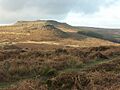
Hathersage Moor from the south, showing Carl Wark with Higger Tor behind it
-
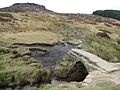
Carl Wark seen from Burbage Brook


