Carrier, Oklahoma facts for kids
Quick facts for kids
Carrier, Oklahoma
|
|
|---|---|

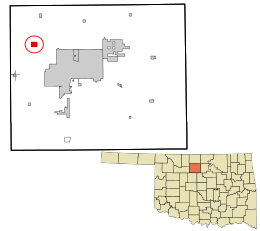
Location in Garfield County and the state of Oklahoma
|
|
| Country | United States |
| State | Oklahoma |
| County | Garfield |
| Area | |
| • Total | 1.23 sq mi (3.18 km2) |
| • Land | 1.23 sq mi (3.18 km2) |
| • Water | 0.00 sq mi (0.00 km2) |
| Elevation | 1,352 ft (412 m) |
| Population
(2020)
|
|
| • Total | 90 |
| • Density | 73.29/sq mi (28.31/km2) |
| Time zone | UTC-6 (Central (CST)) |
| • Summer (DST) | UTC-5 (CDT) |
| ZIP code |
73727
|
| Area code(s) | 580 |
| FIPS code | 40-12200 |
| GNIS feature ID | 2413173 |
Carrier is a small town located in Garfield County, Oklahoma, in the United States. According to the 2020 census, about 90 people live there. It is known for its quiet, rural setting.
Contents
History of Carrier, Oklahoma
The area around Carrier first became home to farmers in 1893. These farmers moved there after the Cherokee Outlet was opened for settlement.
How Carrier Got Its Name
The town of Carrier was named after its first postmaster, Solomon S. Carrier. Early buildings were put up to help the local farmers. These included shops, a school, and a church.
Railway and Town Growth
In 1903, a company called the Northwestern Townsite Company planned to build a railway through the area. They created a new town site about a mile away from the original settlement. All the businesses then moved to this new spot. The railway was completed in 1904.
Economy and Modern Life
For many years, Carrier's economy was mostly based on farming and the oil industry. The town officially became a town in 1972. Today, many people who live in Carrier travel to work in the nearby city of Enid.
Geography of Carrier
Carrier is located in the northwestern part of Garfield County. It is a small town with a total area of about 3.2 square kilometers (1.23 square miles), all of which is land.
Main Roads in Carrier
Oklahoma State Highway 45 runs right through the middle of Carrier. If you go east on this highway, it's about 9 miles (14 km) to the edge of North Enid. If you go west and north for about 11 miles (18 km), you'll reach Goltry.
Another road, Oklahoma State Highway 132, goes through the eastern part of Carrier. Going north on this highway for about 15 miles (24 km) leads to Nash. Heading south for about 6 miles (10 km) takes you to U.S. Route 412. This point is about 7.5 miles (12 km) west of downtown Enid.
Population and People
| Historical population | |||
|---|---|---|---|
| Census | Pop. | %± | |
| 1980 | 259 | — | |
| 1990 | 171 | −34.0% | |
| 2000 | 77 | −55.0% | |
| 2010 | 85 | 10.4% | |
| 2020 | 90 | 5.9% | |
The population of Carrier has changed over the years. In 1980, there were 259 people. By 2000, the population was 77. It then grew slightly to 85 in 2010 and 90 in 2020.
Who Lives in Carrier?
Based on the 2000 census, there were 77 people living in Carrier. Most of the people were White. There were 27 households, and 24 of these were families.
Many households (37%) had children under 18 living with them. The average household had about 2.85 people. The average family had about 3.04 people.
Age Groups in Town
In 2000, the population was spread out by age:
- About 29.9% were under 18 years old.
- About 3.9% were between 18 and 24.
- About 26.0% were between 25 and 44.
- About 32.5% were between 45 and 64.
- About 7.8% were 65 years old or older.
The average age in Carrier was 41 years.
Education
Children living in Carrier attend schools that are part of the Chisholm Public Schools district.
See also
 In Spanish: Carrier (Oklahoma) para niños

